As many of you know, Metra is revamping the BNSF schedule in advance of positive train control (PTC) implementation. And Metra is going all-out with it: it’s got a separate part of the Metra website, there are some pretty slick videos describing what PTC is and why Metra, BNSF, and the Union Pacific are spending so much money on it, and the agency had a comment period for the public to submit their comments. You can say a lot about Metra, but you can’t say they aren’t trying to cover their bases with this upcoming schedule change on their busiest line.
But I think the proposed schedule sucks. And I told Metra I think the proposed schedule sucks.
And they responded.
First and foremost, kudos to Metra for reaching out to my (admittedly very thorough) letter and going point-by-point to try to explain why they’re making the choices they’re making when it comes to the schedule changes. I say this in all honesty, I commend Metra for seeking the input of their riders before rolling out changes wholesale. Granted, I don’t know if Metra directly responded to all of the feedback they received before the comment period ended last Sunday or if they went out of their way to respond to my letter since I posted it here, which then got picked up by Streetsblog, which then ended up on Metra’s internal daily email list of daily news that gets passed around through middle- and upper-management at Metra Headquarters. Either way, I’m impressed.
That said, I have plenty of issues with their response. Below is an annotated version of the response I received. Since Metra chose to refute my initial email point-by-point — which is fine — there will be some breaks in the below email where I’m adding my thoughts. Metra’s email will be posted in blog quotes
like this
And where they’re quoting my initial email I’m placing in italics. Otherwise, the below response has not been edited, other than reducing some of the white space in the initial email.
|
I received a similar comment on Twitter regarding my use of the term “flipping” a train, and that’s on me for not being more clear. I’m well aware that it makes no sense to fully flip a physical consist on a commuter line; that requires some extensive track infrastructure and a lot of space that simply doesn’t exist if a train is scheduled to be short-turned in the middle of the western suburbs. That said, having watched the videos posted a few times, I still don’t understand why Metra — and, to be fair, the industry as a whole — is spending hundreds of millions of dollars to build a new safety system from scratch that requires a full reboot every time the train crew switches ends. Commuter trains on Metra operate in a push-pull configuration, where in Metra’s case the engine is always facing away from Chicago. When the train is heading outbound, the engineer sits in the locomotive cab; when the train is heading inbound, the engineer sits in the upper level of specially-designed cab cars that allow the engineer to operate the train with the engine at the rear, so the train itself never has to flip around. (This saves significant amounts of time, but also would be quite problematic downtown in terms of noise and air pollution at Union Station if the train came in engine-first.) Push-pull isn’t exactly a unique situation, so I still do not understand why the industry spent so much money on a safety system that needs to be fully rebooted every time the crew changes ends and can’t instead go into a pre-programmed “sleep mode” or something similiar that would save that extra time when the crew changes ends to continue their rush-hour service. I’m not an engineer, I’m not an electrical engineer, and I understand the freight railroads like BNSF and UP are more focused on the bottom line than operational efficiency for commuter services (which make up only a small fraction of their revenue), but I’m sincerely hoping that Metra is using their scarce capital dollars to come up with a more efficient system. If the same consist is doing the same “run” of individual trips day in and day out, pre-programming PTC at each end of the consist seems like a no-brainer: instead of booting the system up and entering the required information at the beginning of each trip, the system should be able to offer the engineer a simple yes/no for a pre-programmed trip option when (s)he enters the cab to start the trip and save plenty of time. Of course, as I mentioned in my earlier posts on the topic, Metra adding more time for crews to change ends mid-route is definitely not a negative if it’s done effectively, since it also allows for more buffer time in the schedule to absorb minor delays.
Also, it’s good to see that Metra continues to place a strong focus on safety in terms of their safety briefings. I do understand that track conditions can change while trains are operating, so I understand why Metra/BNSF continues to place a focus on dedicated briefings at each end of the trip. But now I’m curious as to how the CTA can operate a Red Line train out of 95th Street all the way up to Howard, around the balloon loop, and back down to 95th, without needing an intermediate safety briefing. That trip is definitely comparable in time to some of the short-turn trips on Metra. Or likewise when an all-stop trip to Aurora requires a single safety briefing but crews are required to have safety briefings when changing ends on short-turns — for instance, BNSF train #1233 has a safety briefing before it departs Union Station at 1:30pm and doesn’t arrive Aurora until 2:59pm (89 minutes) while train #1263 departs Union Station at 5:13pm, ends at Brookfield at 5:44pm (31 minutes) and requires a separate safety briefing before the crew changes ends and deadheads back to Union Station in ~25 minutes.
But I digress.
“Secondly, while adjusting schedules to address crowding issues in the AM Peak is admirable, adjusting schedules for PM Peak crowding is not needed”. The data disagrees. Our most extremely crowded trains are actually in the outbound peak, with some having counts of over 1,600 people. This is the reason for adjusting the stop patterns in the outbound peak. While it does introduce a new stop pattern to outbound expresses, the current scheme does not balance loads as well as the new proposal. You yourself note that Naperville and Route 59 are the top two stations in terms of ridership, so splitting those two up on the most crowded trains is a way of better matching the capacity to the demand. It is also worth mentioning that we are operating with the same equipment as before, so unfortunately we cannot simply add trains or make certain trains longer. A fair question is why the new 1277 and 1279 have the “old” stopping pattern, and that is because we do not have the equipment available to make 1279 a longer train, so it could not accommodate the passenger loads that would come with either Route 59 or Naperville. Overall, though, we believe that customers will become adjusted to the new patterns on the expresses.
I promise, I’m not here just to crap on Metra, and I’m going to compliment the agency here for using a data-based approach when appraising the afternoon rush service. Balancing service, frequency, and consist length in terms of observed ridership loads is something I will wholeheartedly support on all Metra lines to help find new efficiencies and to keep doing more with less in an era of declining revenues for capital expenditures.
That said, I think my initial point was lost, and I understand that this may be controversial and definitely counter-intuitive: afternoon peak crowding doesn’t matter all that much.
Metra is right to push back on me for that, and I don’t blame some of you reading that to take a step back and tell me I’m crazy. At a certain point, capacity issues in the PM Peak most certainly matter. If you want to grow ridership, you need to make sure there’s capacity available for more riders. Sixteen hundred people on a single train is a huge number, especially when considering that the commuter rail industry considers any peak-period peak-direction passenger load above 95% of seating capacity to be “overcapacity”.
Let’s do some math. Metra’s longest consist — which serves some of the Naperville and Route 59 “super-expresses” — have 11 passenger coaches. At a minimum, each passenger coach seats 135 people, but the older (non-ADA-accessible) coaches can seat up to 150. As any frequent (or even some infrequent) Metra riders know, there’s an additional eight locations on each car that have “comfortable” standing room: in each of the four stairwells up to the upper levels, and in each corner of the vestibule. Some riders straight-up prefer these standing spaces for a variety of reasons: quiet car rules don’t apply in the vestibules, riders getting off at an early stop can stand and be closer to the door on the way out, some people just don’t want to share seats with random riders, and so on. Either way, effective capacity of a Metra train car can be close to 160 people, so an 11-car consist with 146 people in each coach is snug, but nothing to write home about.
Besides: PM Peak crowding is not as big of a passenger concern as AM Peak crowding. In the PM Peak, since Metra does not (and is not currently physically able to practically) operate through-routing on any of their lines, trains sit at the downtown terminal until they’re ready to leave, accepting passengers as they board over anywhere between five and twenty minutes depending on how the schedule and that day’s operations work out. So if you can’t find a seat on an outbound train, you didn’t get to the station early enough. If you get to your train 90 seconds before its scheduled departure, you know you aren’t getting a seat. So afternoon train crowding doesn’t matter. If you want a seat, get to your train earlier, or head up to The Junction for a quick drink until the next train starts boarding and you can get a seat. Worth noting that Metra had no comments about AM peak boarding, which I think is more of a passenger issue since you don’t have a choice as to how crowded your morning train is: when it arrives at your station, it arrives: get on or get left behind. When you think about it, it’s stupid, but it’s human nature: give someone the option to stand and they may choose that option without thinking about it, but force that person to stand and they may be salty about it all the way downtown. Put another way, it’s a classic data issue: the raw numbers (and basic properties of mathematics) will tell you that x will always equal x, but in context of passenger experience, some x’s are more attractive than other x’s.
Moving on.
“Furthermore, the proposed schedule increases scheduled travel times from Union Station to Naperville by a full 25% (from 32 minutes to 40 minutes): and as your second-busiest station which deals with AM crowding in exchange for perhaps the best commuter rail express service in the country, this is probably a non-starter for a significant number of your riders.” The increase in time is a product of a two factors: the load balancing as mentioned in the previous point, as now the train is paired with Lisle. The other reason is that we used signal and GPS data to verify the run times, and it seems that 32 minutes is a bit aggressive. Please also note that schedules list departure times, and the times shown should be reflective of what actually is occurring.
I touched on this in a previous Diverging Approach entry: the schedule says 32 minutes from downtown to Naperville because at some point in the not-so-distant past it only took 32 minutes to get from downtown to Naperville. Now it apparently no longer takes 32 minutes to get from downtown to Naperville. That’s fine, but maybe there should be a stronger focus on why it no longer takes 32 minutes to get from downtown to Naperville instead of just throwing an extra eight minutes (and a new stop at Lisle) at the problem and considering it addressed.
“The existing schedule is complicated enough as it is — in two instances, I personally get back to LaGrange Road sooner on certain express trains that leave after earlier local trains”. We are not quite sure what to make of this criticism – express trains do have shorter run times. Express trains can utilize the third track and sometimes have to pass or “overtake” another train.
I’m all for having express trains, don’t get me wrong. Express trains are great. Every suburb wants their own express train. But this blog advocates Sustainable Transit for All Riders: Leisure, Infrequent, New, and Experienced, so we advocate for things to be as straightforward and as simple as possible. If you’re not familiar with Metra and you pull out your Ventra app to head to LaGrange from downtown during the weekday peak, here’s what you see:
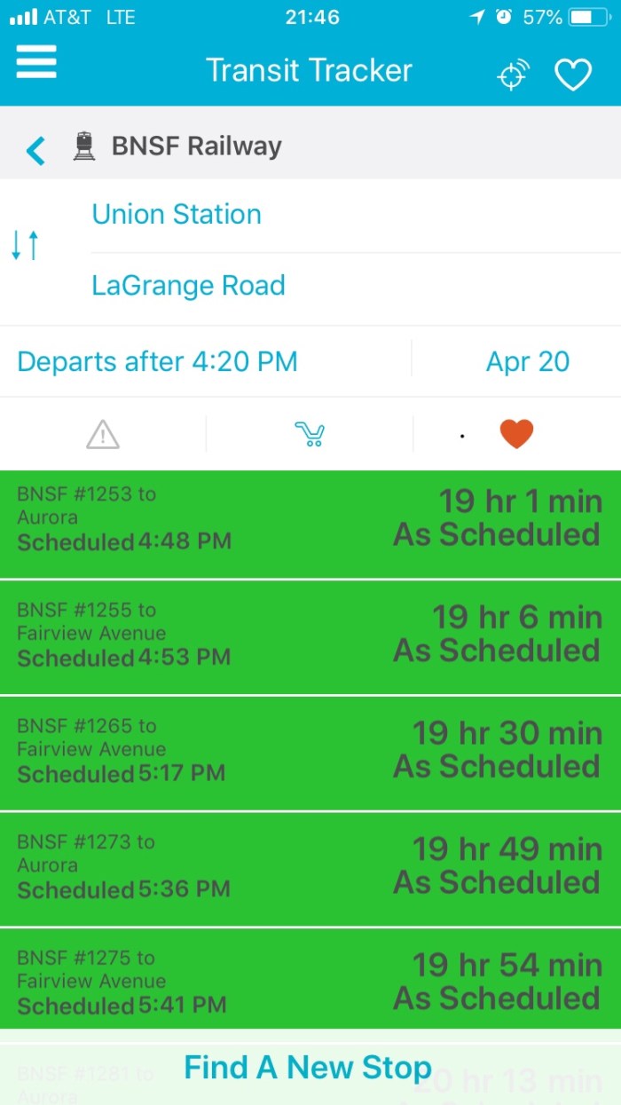
An embarrassment of riches for trains back to LaGrange. But in the above screenshot, the 4:53pm train arrives LaGrange Road before the 4:48pm, and the 5:41pm train arrives LaGrange Road before the 5:36pm train. There are plenty of very good reasons to have suburb-to-suburb local trains sprinkled into the peak-period schedule — we’ll happily advocate for that any day of the week since not everyone commutes to downtown and back — but the above is the customer interface for people who aren’t fluent in the BNSF paper schedule. If you’re trying to gain ridership, especially for infrequent riders, that should be more clearly communicated in the schedule. Furthermore, Metra customer service staff deployed to the downtown terminals for service disruptions don’t necessarily know there are express trains that will get some people home earlier than some local trains, which means sometimes staff will direct riders to the next train departing to their station regardless of whether it’s the fastest trip back to said station. And riders generally don’t like spending more time on a rush hour train than they have to. This I know from experience.
Express trains are good, as long as there’s a way to tell casual riders that this train is express. Metra’s network of express and local service is complicated enough as it is — another thing I’ve tried to address once or twice — and the proposed schedule just cranks up the confusion factor another notch. In an era of on-demand transportation options and flexible work schedules, pointing people to perplexing paper schedules is not an effective long-term approach to growing ridership. Find a way for the Ventra app schedules to be more user-friendly and this issue may become a moot point.
“In summary, with the coming changes of PTC, the way I see it Metra has two options: either work with the PTC implementation to fit the existing schedule as well as possible, or use this opportunity to throw out the existing BNSF schedule and rebuild it from scratch.” This is a fair description of the two options we were looking at in the beginning of this process. And to be clear, we ultimately took the former approach, as most proposed trains have an analogue in the current schedule. But we do anticipate that future schedules changes will be necessary as PTC matures.
At a high level, I think me and whoever is responding to my email are arguing two sides of the same coin: schedule revisions are not necessarily bad things, and wherever possible I agree that Metra should defer to the path of least resistance in terms of the current schedule: if it ain’t broke, don’t fix it; if it is broke, try to fix it in a way that affects the least amount of people who have built their weekly schedules around the trains. But when we’re on the edge of a precipice — changing the time to “flip”/change ends of a train from ten minutes to fifteen minutes on your busiest line, for instance — you might as well blow it up and start from scratch. Don’t be afraid to re-invent the wheel in a situation like this where a majority of your riders are going to see some impact. Metra has the data, they have a reason to change things up, they have a clear slate with CREATE to prioritize passenger trips during peak hours… be bold! Push the envelope! Try something new, call it a pilot, and see how it goes. Metra’s most vocal riders are notoriously cantankerous and will probably complain no matter what happens, so go ahead and break the commuter rail paradigm. If you’re going to change things up, lean into it and take some risks.
The suburbs want Metra to succeed. It isn’t a zero sum game. A stronger commuter rail connection to downtown and the rest of Chicago make the suburbs more livable and more attractive to the millennial demographic being priced out of Chicago but still seeking a car-optional community to move into. But that requires Metra to adapt to a changing demographic and a changing target market, a market that may not take the train downtown Monday through Friday during the traditional peaks, but is more likely to leave the car at home and take the train for fun on the weekend.
Again, thank you for your comments. We are currently evaluating the customer feedback and seeing if some of the common concerns can be accommodated.
Metra
This is admittedly a little nit-picky, but I would’ve been a little more satisfied if a personal response to my comments was signed by an individual, not by “Metra” as a whole. Granted, knowing Metra, the response was composed and vetted by a team of workers, but still, sign it as a response from a person. And that gets into a larger point of the post as well as the post title. The entire tone of the email response — while quite thorough, which is much appreciated — is focused more around justifying the decisions made in the proposed schedule and less around being open to input from the public on the process. Of course, Metra did ask for input on the proposed schedule, so that’s a good step forward, but their public involvement process hasn’t evolved beyond where the public sector was fifteen or twenty years ago. In the planning sector, we would roll our eyes and refer to this strategy as the “DAD” method: Decide, Announce, Defend. On the surface, the agency is asking for public input, but they’ve already decided what they wanted to do, announced how they’re going to do it, and are now defending how they’re going about doing it.
The more recent evolution of public involvement focuses on a context-sensitive solutions (CSS) method, which focuses on agencies focusing on building consensus with affected stakeholders rather than a top-down approach from within the agency. While CSS is a little more difficult to implement with something that requires extensive technical knowledge — such as an operational change to railroad scheduling — a public involvement process that uses community consensus is a much more successful political sell than the old D-A-D method.
Once again, I’m not here to crap on Metra: the agency is using commuter rail best practices to update their schedules in anticipation of PTC, which include a data-oriented approach to schedule revisions. While I do take issue with their mode of public engagement, the agency is (or was, since the BNSF comment period closed four days ago) seeking public input on their proposals, and I’m hoping Metra received some good, productive comments on their proposed schedule that the agency can use to make the new schedule more robust, more reliable, and more attractive to more present and potential riders. PTC implementation will be a paradigm shift throughout the commuter rail industry, and we’re here to encourage and support Metra in being an industry leader to use this opportunity to change the old commuter rail paradigm to be more rider-friendly and become a more attractive transportation alternative to Uber/Lyft and driving, both during the daily commute and for choice leisure trips during off-peak periods.
And I look forward to continued public outreach for schedule revisions to Metra’s other rail lines, since I’ll be happy to offer more constructive criticism and progressive ideas to help encourage more peak and off-peak ridership for Metra.
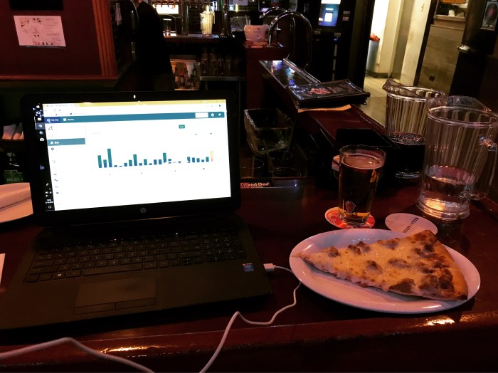
While you’re here, we’re announcing our first social outing for Star:Line at the new Rosemont minor league baseball stadium on Friday, June 15! Easily accessible from Metra’s North Central Service (and also accessible from CTA and Pace service to the Rosemont CTA station), come join us as we ride trains, drink beer, talk transportation, and watch baseball. Event details are over on our Facebook page.