
June 2, 2024 update: download the new informational brochure here. For the most recent version of the plan, visit yard-social.com/2034sight. Original post continues below.
All things considered, it’s actually a pretty good time to be a transit advocate in Chicagoland right now. At the very least, there’s plenty of reason to be optimistic right now:
- A new, progressive mayoral administration is on its way to the fifth floor, with a pretty stacked transportation transition team in tow.
- No longer a long-running punch line, Amtrak is finally operating at 110mph Lincoln Service trains between Joliet and Alton.
- CREATE continues to create positive change in decongesting our rail network, with work advancing on one of its pinnacle projects, the 75th Street Corridor Improvement Program.
- Metra made positive headlines for committing to a regional rail vision in their latest strategic plan.
- The Regional Transportation Authority is proactively trying to address the forthcoming transit fiscal cliff with their Transit is the Answer strategic plan, a wide-ranging call to further the conversation about tapping new revenue sources to keep Chicago-area transit not only solvent, but to be able to modernize into the network we need to serve a post-pandemic world.
- Amtrak, with an assist from CMAP, is leaning hard into a large revisioning of Chicago Union Station and Midwest rail routes as a whole to better position Chicago into the regional rail hub it needs to be.
Unfortunately, there are still setbacks: specifically with that last point, Amtrak missed out on a competitive MEGA grant that would’ve bankrolled a large portion of the project, including the crucial Chicago Union Station (CUS) connector to the St. Charles Air Line (SCAL) bridge. However, this may be a blessing in disguise, as the failed grant application will hopefully encourage Amtrak to make a more compelling pitch for the project. Additionally, they will now also need to better rationalize not only how the project will improve Amtrak’s operations, but what kind of additional benefits a modern Union Station would provide to Metra riders and how it can create new travel patterns within Chicagoland to serve downtown, outlying destinations including McCormick Place and O’Hare Airport, and beyond.
While there are no public plans (to my knowledge) that would detail just what those kinds of services would look like and what kinds of infrastructure improvements would be needed to support a vision like that, there isn’t exactly a vacuum of ideas locally either. The High Speed Rail Coalition’s CrossRail Chicago proposal is one of the gold standards, a long-standing plan to use Amtrak’s CUS and SCAL improvements to electrify parts of the Milwaukee North, Milwaukee West, and North Central Service to allow Metra Electric trains to run from University Park up to — and through — Union Station and out to O’Hare. Amtrak historically also has not been shy about their aspirations to serve the big airport some day as well.
There’s no doubt a truly regional rail network would provide Chicagoland with immeasurable benefits, whether that’s creating a strong regional hub for a network of fast interstate trains that better connect Chicago with our “peers” like Minneapolis, St. Louis, Indianapolis, Detroit, and Cleveland or at the more local level, better connecting the long-neglected South and West Sides with major job centers in the northwest suburbs. Unfortunately, there’s still a lot of uncertainties out there: does O’Hare need express train service? Who would provide it? How can we still accommodate freight traffic and deal with host railroads whose tracks we may/will need to use to enact these grand plans? Do we really need to spend a billion dollars on grade-separating the A-2 junction where the Union Pacific West line currently crosses the Milwaukee North, Milwaukee West, and North Central Service lines? Will increasing freight volumes as part of the Canadian Pacific-Kansas City Southern merger come to fruition, and how will that affect capacity? After all, it’s not like a new full regional rail plan would just fall from the sky…
Yeah, you know where this is going.
- The 2034sight Plan
- Phase 0: The S Lines
- Phase I-A: Through-Running CUS
- Phase I-B: A-2 Modifications and Ashland-Ogden Station
- Phase II-A: Ohio-Columbus Tunnel
- Phase II-B: Fulton Market Connector and CrossTowners
- Phase III – Clinton Street Subway
- Additional Improvements/”Fun Stuff”
- Aim High
The 2034sight Plan
What Chicagoland needs right now is a second Burnham Plan: a bold, yet achievable, vision that will leverage our current infrastructure and strategic investments to create a true regional rail network. More than just a vision, we need a road map that tells us where we want to be, where we need to go, and how we can get there. Enter the Star:Line Chicago 2034sight Plan, a ten-year vision to transform passenger rail in Chicagoland. (Astute readers will note that it is currently 2023 and 2034 is indeed 11 years out, but we’re almost halfway into the year, it’ll take some time to build a movement, and I couldn’t come up with any good 2033 puns, so here we are.) 2034sight isn’t intended to be a groundbreaking revolutionary plan in a vacuum; it stands on the shoulders of giants ranging from CrossRail Chicago to the Coalition for a Modern Metra Electric and the Gray Line, and even a 109-year-old City Club of Chicago plan for through-routing the old steam railroads. (That report, published in 1914, predates the construction of today’s Chicago Union Station.)
What’s Included
2034sight has three key components, grouped into several key phases:
- Phase I-A: Amtrak’s current SCAL connection and basic CUS improvements. This package of projects will allow Amtrak to more directly route some trains into and out of Union Station, including Michigan Service trains and Illini/Saluki/City of New Orleans trains via CN’s freight line that parallels the Metra Electric. Perhaps more importantly at the local level, the project will also allow Amtrak to vacate the Heritage Corridor, running their trains over Metra’s Rock Island line and into Union Station without dealing with the scheduling Russian roulette required to cross four busy freight diamonds at-grade.
- Phase I-B: Improving the A-2 junction is indeed a priority, but in light of Metra taking over Union Pacific’s operations, a full flyover junction is likely no longer warranted with some simple re-routings. However, the junction itself will still need to be reconstructed to accommodate the new routings, as well as the construction a new “superstation” in Fulton Market to provide for easy transfers between numerous lines.
- Phase II-A: Perhaps the most aggressive component of 2034sight would be the Ohio Street Subway, four miles of new double-track (up to 3.5 miles of which would be underground) that would connect the Metra Electric main line near the Museum Campus to the Union Pacific North/Northwest lines near Elston Avenue. This improvement would provide new connections to the CTA Red Line in River North, create a new Streeterville/Magnificent Mile station, and allow the virtually-passenger-only UP-N/UP-NW lines to directly connect with the all-passenger Metra Electric line, maximizing throughput by bypassing Union Station entirely.
- Phase II-B: A 1.25-mile branch of the Ohio Street Subway that, while perhaps the most complex engineering portion of 2034sight, would provide perhaps the most utility: a connection from the Milwaukee District to the Ohio Street Subway, allowing for direct routings from the South Side to O’Hare, as well as a new connection to the CTA Blue Line.
- Phase III: The final component of 2034sight’s core projects would be a second subway, this one under Clinton Street between the existing BNSF/SCAL and the UP-N/NW lines. The Clinton Street Subway would allow for through-running regional rail connected to Union Station and Ogilvie Transportation Center without requiring the wholesale reconstruction of those terminals, as well as allow regional rail services on the current BNSF line to run through to the Union Pacific North/Northwest lines. Crucially, the Clinton Street Subway provides an alternate routing to the Ohio Street Subway, ensuring the core of our regional rail network does not have a single point of failure that could cripple the entire system in the event of a service disruption. (As the final phase, Phase III can also be largely replaced by a reconstruction of Chicago Union Station into a modern through-running terminal; however, the Clinton Street Subway allows for a viable alternative if full reconstruction of Union Station is not deemed feasible or warranted.)
There’s more to the plan than those three core phases (strategic arterial bus services to connect the lines in outlying areas; converting some branch lines into shuttle services; some suburban extensions and infill stations, and a batch of projects literally called “fun stuff” because I don’t take myself too seriously), but the groundbreaking stuff (no pun intended) is above.
What’s Not Included
2034sight is intended to provide a vision of what Chicagoland regional rail could be, and a realistic process as to how we could go about making it happen. However, this plan has several intentional limitations:
- First and foremost: this is still just a “crayon” by a random rider of the system. There’s no insider knowledge here or any sources cited that aren’t publicly available; likewise, estimates as to “realistic” constraints such as freight traffic, engineering slopes and grades, buildability, etc. are just layperson estimates and may not ultimately be accurate. More extensive capacity, modeling, and budgeting work would be required to take this to the next level (although I’m more than happy to help out!).
- Likewise, there may be official plans in the works that are similar to — or nothing like — this plan. This was a leisure exercise by an unaffiliated individual, so don’t read too far into anything presented here.
- Operators of the various services are intentionally vague. While there are some reasonable assumptions (the CTA will probably keep operating the ‘L’, for instance), 2034sight is not intended to be prescriptive — or proscriptive — as to who is responsible to run what. Maybe Amtrak runs it all; maybe Metra starts running to Springfield or Champaign. Don’t know; don’t really care, either. Happy to leave that part to the politicians. The important parts of the plans are what trains go where, how often they run, and ensuring that the network functions as a seamless network rather than a disjointed hodgepodge.
- The 2034sight Plan is intended to stir up a conversation about what can be possible, and in some cases about current missed opportunities, but it is not intended to be some sort of indictment against the current system or “calling out” a particular agency/group of agencies/governmental units. This is supposed to be an aspirational project to get creative juices flowing and demonstrate what’s possible within realistic constraints. Don’t read too far into things.
Okay, that’s enough text for now. You’re here for the maps, and I’m happy to deliver.
Interactive Map
At the risk of losing my audience too early, here’s an interactive map of what the 2034sight Plan calls for, and how it looks with some geographic reality. There’s a lot in here and it took me quite awhile to make, so dive in and don’t forget to toggle the layers on and off to see what the full network could look like. You can also click here to pull the map up in a new window. Keep scrolling down for more information about the projects included in the plan, and for some “glossy” line maps.
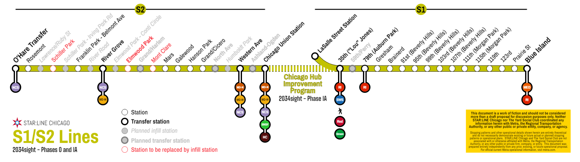
Phase 0: The S Lines
With a ten-year horizon for a truly transformational plan, we’d have to hit the ground running. The good news is, the first step is already basically done. The 2034sight Plan officially begins by “creating” two “new” Metra lines: the S1 Line and the S2 Line. The S Lines use the Yard Social notation we’ve typically used in past maps, where each line and (general) service pattern is assigned a letter of the alphabet, somewhat in alphabetical order counterclockwise around downtown, with A trains going up to Kenosha and W trains going down to 93rd/South Chicago. The S1 Line would be the new name for the Rock Island’s Suburban (Beverly) Branch between LaSalle Street Station and Blue Island. Metra’s already ahead of the curve here, as the Suburban Branch runs semi-independently from the Rock Island Main Line (with timed transfers) during large portions of the day and on weekends.
What would be a change is the “new” S2 Line: a companion service pattern that would operate local service between Chicago Union Station and O’Hare Transfer via the Milwaukee West and the North Central Service. Right off the bat, this service pattern would immediately improve service to O’Hare and connect large swaths of the Northwest Side underserved by the CTA to two of the region’s largest job centers (the Loop and O’Hare). This new service would allow stations like Mars, Hanson Park, and Grand/Cicero to become full-time stations rather than peak-only flag stops as currently scheduled, providing far enhanced service to majority-minority communities without lengthening travel times for suburban riders (see below). While providing all-day service would require some negotiations with Canadian National, the host railroad of the North Central Service north of B-12 (the junction in Franklin Park where the NCS splits off of the MD-W), the portion south of O’Hare Transfer is multi-tracked and largely parallels a freight yard, making this portion the easiest segment to add additional passenger rail service with minimal impacts to freight operations.
The S2 Line also has two additional direct impacts: first, the Milwaukee West could begin full-time “express” service, since all current stops east of River Grove would now be served by the S2 Line; this could reduce the need for the Franklin Park express pattern during peak periods, allowing for peak period trains to be rescheduled for more balanced all-day service.
More importantly: the S2 Line would allow de facto O’Hare Express service to begin immediately, since reallocating the Rosemont, Schiller Park, and Belmont Avenue stations to S2 trains allows NCS trains to run direct from Union Station to O’Hare Transfer with stops only at Western Avenue and River Grove (for MD-W transfers). With this plan, “O’Hare Express” doesn’t need to be a special service, but rather becomes the standard for every NCS trip. (Given the aforementioned freight constraints on Canadian National north of O’Hare Transfer where the line goes down to a single track towards Prospect Heights, dedicated “short turn” NCS service that only operates between Union Station and O’Hare Transfer can be implemented to provide more frequent service to the airport.)
Phase 0 requires approximately zero dollars of new infrastructure and would only require negotiations with CN and CPKC (who dispatches the Milwaukee District and has a strong trackage rights agreement with Metra that gives them essentially veto power over additional off-peak passenger service). While that’s definitely in “easier said than done”, it also could basically happen tomorrow, which is why this is Phase 0.
Phase I-A: Through-Running CUS
2034sight Phase I-A is also already underway, or at least the planning for it is, with Amtrak’s existing work done on their Union Station and St. Charles Air Line package of projects. Trains Magazine has a good write up on the full suite, so I won’t rehash it here. In the interest of striking while the iron is hot, the CUS/SCAL project’s completion would immediately dovetail into 2034sight by using the new connector to connect Lines S1 and S2 into a single S Line that would run from O’Hare Transfer to Blue Island via Chicago Union Station on the existing two through-tracks at CUS. Rather than increase the initial cost and duration of the CUS/SCAL project with electrifying to move Metra Electric trains into Union Station, then electrifying the MD-W/NCS out to O’Hare, combining the S1 and S2 Lines would allow Metra to operate through service with existing rolling stock or with new not-fully-electrified dual mode train sets. (I’m personally a fan of Stadler’s dual-mode FLIRTs, but that’s a procurement question that’s generally out of scope for this plan. If you want to know more about FLIRTs, ask literally anyone on Transit Twitter and you’ll get plenty of strong opinions.) If electrification will be a hard sell at first — and I have no doubts that it would be — this plan gets diesel service up and running quickly. As Mark Twain said, “few things are harder to put up with than the annoyance of a good example”, so let’s run the service and then figure out the best ways to upgrade the propulsion. Depending on freight constraints, S Line trains could operate every half hour.
This plan also assumes that, as part of Amtrak’s improvements in Phase I-A, Lincoln Service trains and the Texas Eagle get rerouted in Joliet to use Metra’s Rock Island line to run up to the SCAL and into Union Station. As such, the slots currently used by Amtrak on the Heritage Corridor — five daily in each direction as of now — would be reallocated to Metra, allowing Metra to operate up to eight daily round-trips on weekdays and five daily round-trips on weekends. While those headways would be far from a proper “regional rail” line, it’d still be a big step forward for the Heritage Corridor and would still be transformative for southwest suburbanites.
I promised maps, so here’s what Phase I-A looks like visually. (Note: 2034sight assumes that the 75th Street CIP gets completed and SouthWest Service trains get re-routed into LaSalle Street Station.)
Phase I-B: A-2 Modifications and Ashland-Ogden Station
Phase I-B, like Phase I-A, isn’t really a new project. Plans to improve the A-2 junction and to build a new infill station in Fulton Market are already underway. This slide deck from a joint City of Chicago/Metra virtual public meeting from October 2021 lays out the case for both projects quite nicely, so I won’t go into too much detail, other than offering two quick points:
- First: an infill station at Ashland Avenue — personally, I prefer just east of Ashland to allow access to Ogden as well — would also provide a crucial interagency link and allow Ashland Avenue to become a strategic north-south connection to link with almost all the regional rail lines as well as the ‘L’ lines. Bring back Ashland BRT!
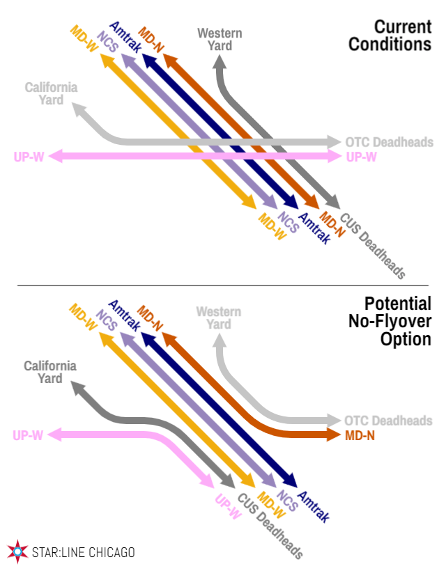
- Second: that slide deck puts the price of an A-2 flyover at over a billion dollars. However, a flyover is likely unneeded now that Metra will be taking over operations on the three Union Pacific lines. Currently, A-2 is congested because of several crossing movements: UP-W trains and midday layovers from Ogilvie have to cross the Milwaukee District at-grade with Ogilvie layovers going into and out of UP’s California Yard; likewise, MD-N/MD-W/NCS/Amtrak trains have to cross the Union Pacific tracks at-grade along with Union Station North Concourse layover trains, which head to Metra’s Western Avenue Yard. If Metra is taking over operations from UP — and crucially, if that also includes California Yard — additional turnouts at A-2 would allow Union Station layovers to head to the California Yard while Ogilvie layovers head to the Western Avenue Yard. Likewise, with fewer restrictions on which crews can operate where, UP-W trains could head to Union Station and MD-N trains could head to Ogilvie, greatly minimizing the number of crossing conflicts at A-2. (In a future regional rail paradigm, there would be far fewer trains laying over midday anyway since trains would keep operating throughout the day rather than with heavy peaks.) In a graphical nutshell:
Of course, if Union Pacific West trains started going into Union Station alongside Milwaukee West trains, we’d have to finally get around to renaming the lines. 2034sight, like many other Diverging Approach proposals from the last five years, recommends a comprehensive lettering scheme with a companion “heritage” naming and iconography system to simplify service patterns and line names. We’ll get into that in Phase II-B: while the Ashland-Ogden superstation would be valuable for many reasons in terms of opening up an infill station in Fulton Market, it’s not integral to the larger regional rail evolution until later on.
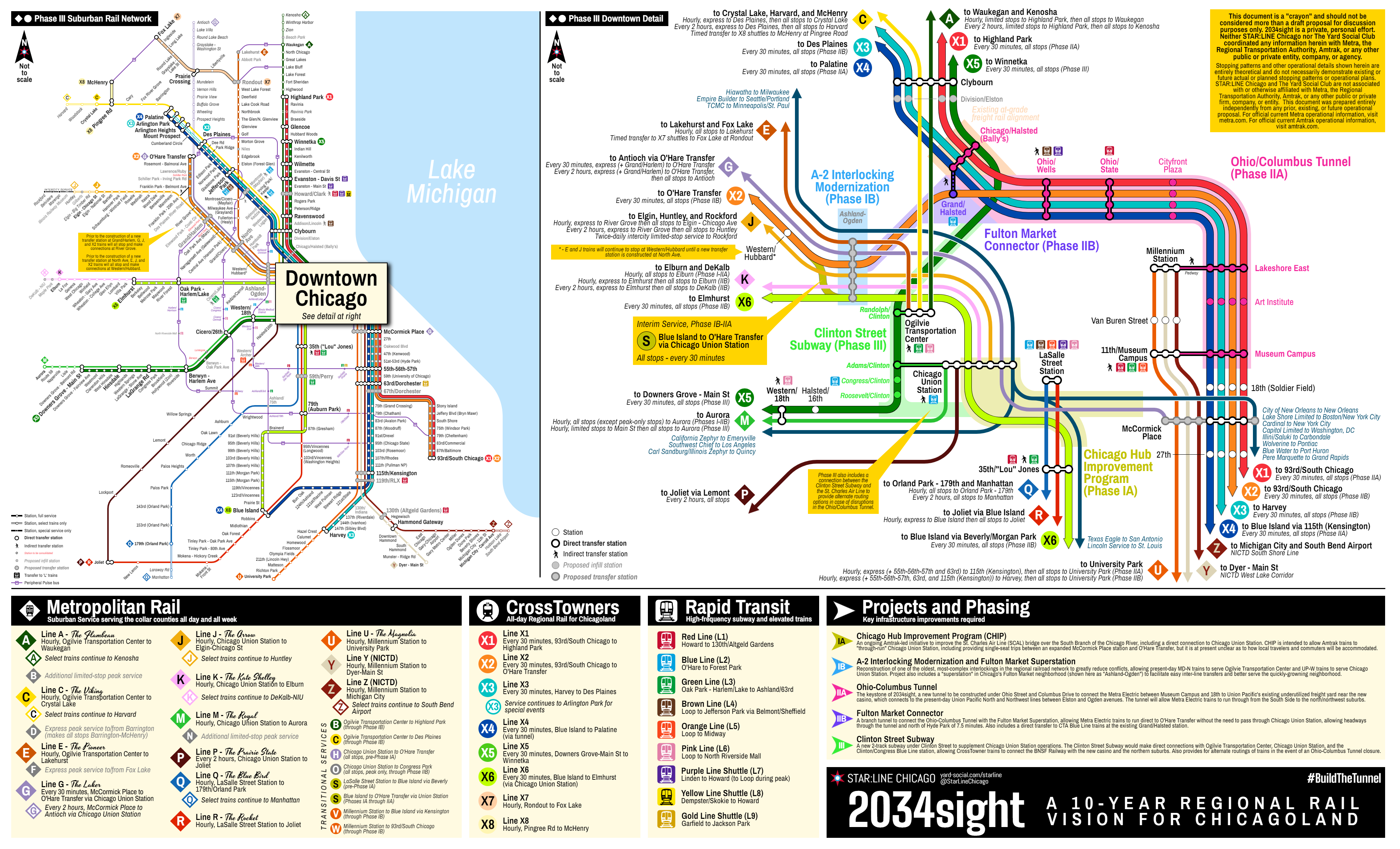
Phase II-A: Ohio-Columbus Tunnel
The most ambitious component of 2034sight is the Ohio-Columbus Tunnel, about four miles of new construction to finally provide a modern, efficient north-south connection between the Metra Electric and the Union Pacific North and Northwest lines, as well as laying the foundation for direct connections from the South Side to O’Hare in Phase II-B. The cost of this project would undoubtedly be counted in the billions, but the benefits would be incredibly high, with one-seat trips now possible between Highland Park and Hyde Park, and between Des Plaines and Blue Island. Additionally, by tunneling under the river (twice) to lay a modern subway that connects four virtually-freight-free branches rather than routing additional trains over the SCAL bridge (which will likely remain a lift bridge of some sort) and onto tracks dispatched by CPKC, potential service reliability and frequency will be much higher than dealing with the freight congestion that would likely be a conflict with a Union Station routing.
It’s also worth noting that, as shown, the four miles of the Ohio-Columbus Tunnel is something of a “worst-case” scenario from an engineering perspective, with a very conservative route presented that would likely be the maximum length of grade-separated alignment required. From south to north, the sketch below calls for a cut-and-cover construction under Columbus Drive through Grant Park; an engineering solution that would add a portal at/near Millennium Station could shave a full mile off the total length of the alignment. (That said, cut-and-cover Columbus would also provide an ideal opportunity to permanently close Columbus to car traffic through Grant Park, which would also be a major benefit purely from an urbanism standpoint.) For a regional context, the State Street Subway (CTA Red Line) is just under five miles long, so while the Ohio-Columbus Tunnel would be a major project, it also would not be unprecedented in Chicago.
The subway would then dive under the river and curve around to Ohio Street, where more cut-and-cover construction could be used between the two river tunnels to help lower costs. The tunnel would then dive under the North Branch of the Chicago River, emerging from a portal in the old CNW rail yard near the new casino. Trains would then continue at-grade on the existing freight right-of-way to tie into the existing UP-N/NW tracks near Elston.
The Ohio-Columbus Tunnel — including the full Columbus Drive alignment — would include up to seven new stations to provide service to downtown and to make additional connections. Some of these stations also include logical real estate integration opportunities, which can help to fund the larger project.
| Station | Location | Transfers | Notes |
| Museum Campus | Columbus north of Roosevelt | Metra Electric, South Shore Line | Could be directly integrated with existing 11th St/Museum Campus station. Alternatively, the existing station can be used, with the subway cutting over to Columbus Drive through Upper Hutchinson Field. |
| Art Institute | Columbus & Jackson | none | Also serves Grant Park and Buckingham Fountain. |
| Lakeshore East | Columbus & Lake and/or South Water | Metra Electric, South Shore Line | Connects to the Pedway System, including Millennium Station. Building site available at southeast corner of Columbus and Lake, for an integrated development potential to help fund the larger project. |
| Cityfront Plaza | ~233 E Illinois St | Buses | New station to serve Streeterville and the southern end of the Magnificent Mile. Another integrated TOD site available at the southwest corner of Columbus and Illinois. |
| Ohio/State | Ohio & State | Red Line | Direct connection to Red Line trains via the former Ohio auxiliary entrance to Grand/Lake. |
| Ohio/Wells | Ohio & Wells | Brown and Purple Lines | Short walk to Merchandise Mart for CTA transfers. Station can also be moved (or have auxiliary entrances) one block west at Franklin, where two surface parking lots are extant for development and a future direct CTA transfer station can be considered. |
| Chicago/Halsted (Bally’s) | Chicago & Halsted | Buses | Also serves the new casino. |
Once constructed, the Ohio-Columbus would carry the new X Lines, with trains from Highland Park and Des Plaines to 93rd/South Chicago and Blue Island via 115th/Kensington. By using Des Plaines as the Northwest terminus, the only conflicts on the entire route would be CPKC freight (and MD-N/Amtrak passenger service) crossing at Mayfair Junction, and Metra’s “normal” trains up to Waukegan/Kenosha, Crystal Lake/Harvard/McHenry, and University Park (although the impacts of the latter would be minimal since the main line of the Metra Electric has four tracks in an express/local configuration). Like the S Line above, the X Line’s services would have spillover benefits for those Metra lines as UP-N, UP-NW, and ME (University Park) trains could permanently switch to a “limited” or express stopping pattern.

Phase II-B: Fulton Market Connector and CrossTowners
While the Ohio-Columbus Tunnel would open the door to modern regional rail in Chicago with proper north-south through-running, the Fulton Market Connector would be what truly unlocks the full potential of the concept. The connection would be a ~1.25-mile branch that splits off the Ohio-Columbus Tunnel just west of the North Branch of the Chicago River. The tunnel would cut diagonally across the street grid — with a new integrated station at Grand/Halsted to provide direct connections to the CTA Blue Line — and under the Kennedy Expressway, before surfacing along Kinzie Street and tying directly into the Phase I-B Ashland-Ogden superstation. This would likely be the most challenging portion of 2034sight from an engineering perspective, as the ramp from the above-grade tracks at Ogden to dive deep enough to go under the Kennedy (which itself is depressed through Hubbard’s Cave) would have a slope of 2.5-3%. That slope is steep enough to be a challenge, but with multi-unit consists it should still be manageable. (I estimate a slope of similar steepness — but of a much shorter length — can already be found in Metra territory at 69th Street where the South Chicago Branch flies under the Metra Electric main line.)
With the opening of the Fulton Market Connector, the great rebranding would take place as the new vision of regional rail fully takes hold. The project would (or could) overlap with swapping the MD-N and UP-W into Ogilvie and Union Station, respectively. The new branding would provide three groups or tiers of passenger rail service, not including Amtrak’s intercity service:
- The ‘L’ Rapid Transit metro service, providing the CTA’s current rapid transit metro-style of service. On maps, service is indicated with square icons. While the color-coded lines would continue (especially in the vernacular language of a region that still insists on “Sears Tower”), the lines would be officially given line numbers, preceded with an “L” for lines L1-L9. (Astute readers will notice that there currently are only eight ‘L’ lines; 2034sight calls for the creation of a “Gold Line” shuttle to replace the Cottage Grove Branch of the Green Line. The method to the madness: a Cottage Grove shuttle would cut headways to Englewood in half, and would allow for a re-extension of the 63rd Street Elevated to Jackson Park — or at least Dorchester, for a rebuilt Metra transfer station — to be a single track, which would help to mitigate some of the concerns in Woodlawn about the reconstruction of the elevated structure casting dark shadows on 63rd.) Important note: 2034sight is intended to be a regional rail plan. While some changes to ‘L’ service are recommended, this plan is not intended to be a total reimagining of the ‘L’ system. Other changes to the ‘L’ system may be viable, but are considered out of scope for this plan.
| Line Name | Line Number | 2034sight Extensions | Notes |
| Red Line | L1 | 95/Dan Ryan to 130th | Extension currently planned |
| Blue Line | L2 | none | |
| Green Line | L3 | none | Cottage Grove branch spun off into a shuttle service (see below) |
| Brown Line | L4 | Kimball to Jefferson Park | Extension can be replaced by Lawrence Avenue BRT |
| Orange Line | L5 | none | |
| Pink Line | L6 | 54/Cermak to North Riverside Mall | Right-of-way mostly intact; Douglas Branch originally operated as far west as Oak Park Ave until 1952 |
| Purple Line | L7 | none | |
| Yellow Line | L8 | none | |
| Gold Line | L9 | 63rd/Cottage Grove to 63rd/Dorchester or Jackson Park | Current Cottage Grove branch of the Green Line; rebranded as a shuttle service to decrease headways in Englewood and Woodlawn |
- CrossTowner Regional Rail service, encompassing the new through-routes through downtown Chicago to connect the northern and northwestern passenger rail lines with the southern lines. On maps, service is indicated with circular icons. Phase II-B would see the formation of five CrossTowners, branded with line numbers preceded by an “X”. Each line below can likely support half-hour headways (two trains per hour (tph)), but more extensive capacity analyses will be required. In the “core” segment (Ohio/Wells to 67th), even with 2tph per service, interlacing trains will offer 7-8min headways all day.
| Line Name | Southern Terminus | Northern Terminus | Notes |
| X1 | 93rd/South Chicago | Highland Park | Supplements Line A (UP-N) suburban trains. Prime candidate for full electrification. Minimal constraints to frequent service. |
| X2 | 93rd/South Chicago | O’Hare Transfer | Supplements Line G (NCS) and Line J (MD-W) suburban trains. Replaces north end of former S Line; transfers available at Ashland-Ogden. Freight traffic will likely be a constraint to more than 2tph between Ashland-Ogden and O’Hare Transfer. With X1 CrossTowners, provides 15-min or better service on South Chicago branch. |
| X3 | Harvey | Des Plaines | Supplements Line C (UP-NW) and Line U (ME-University Park) suburban trains. Prime candidate for full electrification. Primary constraint to frequent service is Mayfair Junction, but 2tph is likely feasible. Trains can be extended to Arlington Park for special events. |
| X4 | Blue Island | Palatine | Supplements Line C (UP-NW) suburban trains. With X3 trains, provides 15-min or better service between Des Plaines and Clybourn, and between 67th and 115th (Kensington). Freight constraints at Mayfair Junction and at Deval Junction (northwest of Des Plaines) will constrain X4 headways. |
| X6 | Blue Island | Elmhurst | Supplements Line K (UP-W) suburban trains. Like S Line trains, operates via Chicago Union Station. Can continue to use current/non-electrified rolling stock. Heavy freight traffic will be a constraint west of Ashland-Ogden. |
- Metropolitan Rail Suburban Service passenger trains, which serves as a continuation of more “traditional” Metra service in the outer suburbs where densities may not warrant regional rail frequencies. Half-hour headways may still be reasonable, but hourly headways are likely sufficient for most trips. Additionally, with CrossTowner service overlaid, many Metropolitan Rail trains can make fewer stops, increasing speeds and reducing trip times that may allow for higher frequencies. Since Metra won’t be fully replacing their entire fleet in the next ten years, these trains would use Metra’s existing rolling stock on generally-non-electrified infrastructure. For the purposes of a fully integrated network, South Shore Line trains would also be included in the Metropolitan Rail network. (“Metropolitan Rail” is a nod to the original portmanteau that created the “Metra” name.)
| Current Name | New Name | Routing | Notes | |
| UP-N | Line A | Ogilvie to Waukegan | Select trains continue to Kenosha. South of Highland Park, Line A trains only stop at Glencoe, Winnetka, Wilmette, Evanston – Davis St, Ravenswood, and Clybourn. Use X1 trains for intermediate stops. Trains will stop at Ravinia Park for special events at Ravinia Festival. | |
| UP-NW | Line C | Ogilvie to Crystal Lake | Select trains continue to Harvard. South of Palatine, trains only stop at Arlington Park, Arlington Heights, Mount Prospect, Des Plaines, Jefferson Park, and Clybourn. Use X3 or X4 trains for intermediate stops. Trains will stop at Irving Park for special events at Wrigley Field. | |
| UP-NW | Line D | Ogilvie to McHenry | Operates during the peak only; at all other times, shuttle services operate between McHenry and Pingree Road to connect with Line C trains. | |
| MD-N | Line E | Ogilvie to Lakehurst | Includes an extension to Lakehurst, with infill stations at Abbott Park and Rondout. | |
| MD-N | Line F | Ogilvie to Fox Lake | Operates during the peak only; at all other times, shuttle services operate between Fox Lake and Rondout to connect with E Line trains. F Line trains run express between Glenview and Ashland-Ogden. | |
| NCS | Line G | McCormick Place to Antioch via Chicago Union Station | Operates every half hour between McCormick Place and O’Hare Transfer with extremely limited stops (Chicago Union Station, Ashland-Ogden, and Grand/Harlem). Select trains continue beyond O’Hare Transfer to Antioch. | |
| MD-W | Line J | Chicago Union Station to Elgin | Includes an extension to Huntley. Select trains continue to Huntley (requires a new connection west of Big Timber Road, currently planned as part of Chicago-Rockford Amtrak service). East of Franklin Park, trains only stop at Grand/Harlem, North Ave, and Ashland-Ogden. Use X2 trains for intermediate stops. Special excursion service continues beyond Huntley to the Illinois Railway Museum on select summer weekends. | |
| UP-W | Line K | Chicago Union Station to Elburn | Includes an extension to DeKalb. Select trains continue to DeKalb. East of Elmhurst, trains only stop at Oak Park – Harlem/Lake and Ashland-Ogden. Use X6 trains for intermediate stops. | |
| BNSF | Line M | Chicago Union Station to Aurora | Makes all non-peak-only stops until Phase III; after Phase III, M trains make all stops from Aurora to Downers Grove – Main St, then make limited stops (Hinsdale, LaGrange Road, Berwyn – Harlem Ave, Cicero/26th, and Western/18th). Runs express during peak periods when N trains are operating. | |
| BNSF | Line N | Chicago Union Station to Downers Grove – Main St | Operates during the peak only as existing “middle express” service (trains stop Downers Grove – Fairview Ave to Congress Park, then express to Chicago Union Station). | |
| BNSF | Line O | Chicago Union Station to Brookfield | Operates during the peak only, making all stops between Brookfield and Chicago Union Station. To be phased out once X5 service begins in Phase III. | |
| HC | Line P | Chicago Union Station to Joliet | Eight daily round-trips on weekdays; five daily round-trips on weekends. | |
| SWS | Line Q | LaSalle Street Station to 179th/Orland Park | Select trains continue to Manhattan. | |
| RI | Line R | LaSalle Street Station to Joliet | All trains operate via the main line; transfer to X6 trains at 79th (Auburn Park) for Suburban Branch service. At Joliet, transfer to special excursion service to LaSalle-Peru on select summer weekends. | |
| ME | Line U | Millennium Station to University Park | South of McCormick Place, expresses to 55th-56th-57th. No service to 59th – University of Chicago. South of 63rd, expresses to Harvey (also stops at 115th (Kensington) and 119th (RLX)). Use X3 trains for intermediate stops. | |
| NICTD – West Lake Corridor | Line Y | Millennium Station to Dyer | South of McCormick Place, operates express to 115th (Kensington) with stops at 55th-56th-57th and 63rd/Dorchester. Use X3/X4 trains for intermediate stops. | |
| NICTD Main Line | Line Z | Millennium Station to Michigan City | Select trains continue to South Bend Airport. South of McCormick Place, operates express to 115th (Kensington) with stops at 55th56th-57th and 63rd/Dorchester. Use X3/X4 trains for intermedite stops. |

Phase III – Clinton Street Subway
While the Ohio-Columbus Tunnel and the Fulton Market Connector would be nothing short of transformative for the City of Chicago and our region as a whole, there are still some shortcomings. As Metra’s busiest line, the BNSF Railway deserves proper regional rail service. Additionally, the Ohio-Columbus Tunnel creates a single point of failure system, which leaves service susceptible to delays in the event of service disruptions. (Strike up a conversation with CTA Blue Line riders if you need more information as to why single points of failure are bad in a transit network.)
As such, the final major phase of 2034sight is a second new alignment, approximately 2.5 miles of dual track under Clinton Street through the West Loop between the BNSF/SCAL and the Ohio-Columbus Tunnel. This component should be far cheaper than the Ohio-Columbus Tunnel, since the route can theoretically be built entirely with cut-and-cover construction, with no new crossings under the Chicago River and with minimal or no additional right-of-way required outside of the existing Clinton Street footprint.
| Station | Location | Transfers | Notes |
| Roosevelt/Clinton | Roosevelt & Clinton | Buses | Auto-oriented neighborhood that could be ideal for TOD upzoning. |
| Congress/Clinton | Clinton & Congress-Tilden (under the Ike) | L2 (Blue) Line | New integrated station that would finally add elevators to the Clinton Blue Line and provide direct connections to the Old Post Office. |
| Adams/Clinton (Union Station) | Clinton & Adams | G, J, K, M, P Lines | Direct connection to Chicago Union Station via the Great Hall. |
| Randolph/Clinton | Clinton & Randolph | A, C, D, E, F, L3 (Green), L6 (Pink) Lines | Combined with the reconstruction of the Northwest Passage, this station would serve as a direct connection to Ogilvie and the Clinton/Lake ‘L’ station. |
It’s worth noting that many of Phase III’s goals could also be accomplished with a modernization of Union Station, including through-routing trains and a direct connection to the Clinton Blue Line; if a connection to the Ohio-Columbus Tunnel is included as part of larger Union Station reconstruction efforts, the Clinton Street Subway may not be needed for CrossTowners.
With Phase III in place, 2034sight calls for a new X5 service pattern that would provide CrossTowner service on the BNSF corridor as far west as Downers Grove, through-routed up to Winnetka to provide additional service on the North Side. X5 trains would also allow Metra to streamline the current BNSF service, with trains east of Downers Grove – Main Street only stopping at Western/18th, Cicero/26th, Berwyn – Harlem Ave, LaGrange Road, and Hinsdale to speed up service between downtown and the busiest stations on the line (Aurora, Route 59, and Naperville).
Additional Improvements/”Fun Stuff”
Before revealing the full system maps, 2034sight also calls for a variety of other smaller, lower-priority projects. These improvements can be implemented in any sequence, and represent “add-ons” that contribute to a more cohesive network, but are not necessarily required for core implementation and goals of the plan.
In no particular order:
- CrossTowner X7. While it falls under the CrossTowner umbrella in terms of rolling stock, hours of service, etc., X7 is a shuttle operation along the Fox Lake branch of the Milwaukee North line. Since freight traffic is expected to increase along the existing MD-N, and since the line currently only has two tracks for most of its length, an interim solution to accommodate an extension to Lakehurst (to also serve Abbott Park, as well as convenient connections to Gurnee Mills and Six Flags) is to turn this line into an off-peak shuttle operation, with timed transfers at a new infill Rondout station. This will allow suburban service to continue to operate at least hourly on both branches while still accommodating freight (and Amtrak Hiawatha) traffic. During peak periods, a “traditional” commuter rail pattern (F Line) can still operate with direct service from Fox Lake into downtown Chicago. The plan also calls for bus connections in the west between Fox Lake and McHenry, and in the east between Rondout and Lake Bluff. Long-term, the X7 line can be extended east on the old North Shore Line right-of-way to directly connect with A Line trains at Lake Bluff, and western expansions can also be considered.
- CrossTowner X8. A companion project to the X7, CrossTowner X8 would provide off-peak shuttle service between McHenry and Pingree Road, similarly boosting service to McHenry without negatively impacting Crystal Lake, Woodstock, and Harvard. Also similar to the X7 plan, a traditional commuter pattern (D Line) can still provide direct peak service from McHenry to downtown Chicago. X7 and X8 can also serve as “proving grounds” for future fleet procurements.
- Key Bus Corridors. Despite the name, CrossTowners are not intended to initially include the Mid-City Transitway plan along the old Crosstown Expressway corridor. Instead, a network of key bus routes structured similar to Pace’s Pulse routes are identified to provide convenient links between lines outside of downtown, with companion infill station recommendations as applicable. These routes are shown on the map as “Bx” routes — as reference only; it’s expected that these routes would become part of Pace’s regional Pulse network — which includes the following connections (stations marked with an asterisk are proposed infill stations):
- B3: 79th (L5 at Midway, Q at Wrightwood, R/X6 at 79th (Auburn Park), L1 at 79/Dan Ryan, X3/X4 at 79th (Chatham), X1/X2 at 79th (Cheltenham))
- B4: Ashland/Western/95th (A/C/X1/X3/X4/X5 at Clybourn, L2 at Chicago/Milwaukee, E/G/J/K/X2/X6 at Ashland-Ogden*, L3/L6 at Ashland/Lake, L2 at Illinois Medical District, M/X5 at Western/18th, L6 at Western/21st, P*/L5 at 35th/Archer, L5 at Western/49th, L3 at Ashland/63rd, Q at Ashland/75th*, X6 at Brainerd, R at 95th/Longwood, L1 at 95th/Dan Ryan, X3/X4 at 95th/Chicago State)
- B8: Cicero (L5 at Midway, M/X5 at Cicero/Ogden, L6 at Cicero/Cermak, L2 at Cicero/Congress, L3 at Cicero/Lake, X5 at Cicero/Kinzie*, X2 and Grand/Cicero, E/F at Mayfair, C/D/X3/X4/L2/L4 at Jefferson Park)
- B9: Dempster (A/X1/X5/L7 at Evanston – Davis St, L10 at Dempster-Skokie, E/F at Morton Grove, C/X3/X4 at Des Plaines, G/X2 at O’Hare Transfer)
- B10: Harlem (L5 at Midway, P at Summit, M/X5 at Berwyn – Harlem Ave, L6 at Harlem/Cermak*, L2 at Harlem/Congress, K/X5/L3 at Oak Park – Harlem/Lake, J/X2 at Harlem/Grand*)
- B78: D/X8 at McHenry, F/X7 at Fox Lake
- B176: E/F/X7 at Rondout, A at Lake Bluff
- Infill stations. To enhance regional connectivity, a variety of infill stations — as well as modest service extensions, in some cases — are also recommended. While these improvements would all create additional value and create a more seamless transit network, these are less constrained in terms of fulfilling the overall goals of 2034sight. (There’s also almost 50 of them listed below, so many of these may be budget-constrained regardless.)
| Station Name | Location | Line(s) Served | Notes |
| Beach Park | Wadsworth Road, Beach Park | A | Adds service to Illinois Beach State Park. |
| Howard/Clark | Howard & Clark, Chicago | A, X1, X5 | New station within walking distance of the CTA’s Howard terminal. Auxiliary entrances likely at Rogers Avenue. |
| Addison/Lincoln | Addison, Lincoln, & Ravenswood, Chicago | X1, X5 | Infill station that also provides direct transfers to L4 (Brown) Line trains. |
| Division/Elston | Division & Throop, Chicago | X1, X3, X4, X5 | |
| Montrose (Mayfair) | Montrose & Knox, Chicago | X3, X4 | Provides convenient connections to E trains at Mayfair and L2 (Blue Line) trains at Montrose/Kennedy. |
| Belmont/Kedzie | Belmont & Kedzie, Chicago | X3, X4 | |
| Western/Logan | Western & Logan Blvd, Chicago | X3, X4 | |
| Lakehurst | IL 120 between I-94 and Waukegan Rd, Waukegan | E | Service extension. Provides convenient access to new casino as well as logical park-and-ride transfer location for drivers on the Tri-State Tollway and Skokie Highway. Can also operate shuttle buses to Gurnee Mills and Six Flags Great America. |
| Abbott Park | IL 137 at I-94, Lake Bluff | E | Part of service extension to Lakehurst. Major reverse-commute destination (Abbott Laboratories). |
| Rondout | IL 176, Lake Bluff | E, F, X7 | Infill station. Provides transfers between E trains to/from Chicago and X7 CrossTowner shuttles to/from Fox Lake. Technically a rebuilt station; original Rondout station closed in 1984. |
| Niles | Howard St at Gross Point Rd, Niles | E | |
| Ashland-Ogden | Ashland Ave & Kinzie St, Chicago | E, G, J, K, X2, X6 | Infill “superstation” as part of Phase I-B. Links up with a Key Bus Corridor (B4). |
| Humboldt Park | Kedzie & Grand, Chicago | X2 | |
| North Ave | North Ave & Lawndale Ave, Chicago | E, X2 | |
| Grand/Harlem | Harlem Ave & Fullerton Ave, Elmwood Park | G, J, X2 | Replaces Mont Clare and Elmwood Park. Links up with a Key Bus Corridor (B10). |
| Elmwood Park – Conti Circle | Grand Ave & 77th Ct, Elmwood Park | X2 | Replaces Elmwood Park. (In addition to possible redundancy resulting from Grand/Harlem, a planned grade separation of Grand Avenue may necessitate closure/relocation of the existing Elmwood Park station regardless.) |
| River Road | Des Plaines River Rd & Franklin Ave, River Grove | X2 | |
| Schiller Park – Irving Park Rd | Irving Park Rd & Prairie Ave, Schiller Park | X2 | Replaces Schiller Park. |
| Lawrence/Ruby | Lawrence Ave & Ruby St, Schiller Park | X2 | Replaces Schiller Park. |
| Huntley | west of Huntley | J | Service extension. |
| Gilberts | Railroad St & Jackson St, Gilberts | J | Part of service extension to Huntley. |
| Union/IRM | Olson Rd & Hemmingsen Rd, Union | — | Excursion service to the Illinois Railway Museum. |
| DeKalb/NIU | Lincoln Hwy, DeKalb | K | Service extension. Station location to be determined. |
| Maple Park | Pleasant St & Kennebec St, Maple Park | K | Part of service extension to DeKalb. |
| Cicero/Lake | Cicero Ave & Kinzie St, Chicago | X6 | Links up with a Key Bus Corridor (B8). Also offers connections to L3 (Green Line) trains. |
| Berwyn – Oak Park Ave | Stanley Ave between Oak Park Ave and East Ave, Berwyn | X5 | Replaces Berwyn and LaVergne. |
| Western/Archer | Western Ave & 36th St, Chicago | P | Links up with a Key Bus Corridor (B4) and Orange (L5) Line trains at 35th/Archer. |
| Ashland/75th | Ashland Ave & 75th Ave, Chicago | Q | Links up with a Key Bus Corridor (B4). |
| 59th/Perry | 59th St & Perry Ave, Chicago | Q, R, X6, L3 | New Washington Park “superstation”. |
| Oakwood Blvd | Oakwood Blvd & Lake Park Ave, Chicago | X1, X2, X3, X4 | |
| 67th/Dorchester | 67th & Dorchester Ave, Chicago | X1, X2, X3, X4 | Current status of 67th is unclear. Station has a dedicated page on the Metra website, and Metra reports replacing the platforms at 67th this year (2023). |
| 119th (RLX) | 370 E 119th St, Chicago | U, X3, L1 | New transfer station between the Red Line Extension (RLX) and X3 CrossTowner trains. |
| 130th/Indiana | 130th & Indiana, Chicago | X3 | |
| 130th (Altgeld Gardens) | 130th & Doty Ave, Chicago | Y, Z, L1 | Infill South Shore Line station to provide connections to the Red Line Extension and to better serve Altgeld Gardens. |
| Elston/Kostner | Lawrence & Elston, Chicago | L4 | Part of L4 service extension to Jefferson Park. |
| Pulaski | Lawrence & Pulaski, Chicago | L4 | Part of L4 service extension to Jefferson Park. |
| Kimball/Lawrence | Lawrence & Kimball, Chicago | L4 | Part of L4 service extension to Jefferson Park. Replaces current Kimball station. |
| 16th | 16th & Clark, Chicago | L1 | Infill L1 (Red Line) station at SCAL. Also serves The 78 development. (Preliminary planning underway.) |
| Western/Lake | Western & Lake St, Chicago | L3 | Links up with a Key Bus Corridor (B6). |
| North Riverside Mall | Harlem Ave & Cermak Ave, Berwyn | L7 | Service extension. Links up with a Key Bus Corridor (B10). |
| Ridgeland-East | Cermak Ave between Ridgeland and East Ave, Berwyn | L7 | Part of L7 service extension to North Riverside Mall. |
| Austin/Cermak | Austin Ave & Cermak Ave, Berwyn | L7 | Part of L7 service extension to North Riverside Mall. |
| 63rd/Dorchester | 63rd & Dorchester Ave, Chicago | L9 | Service extension to connect with U, Y, Z, X1, X2, X3, X4 trains at 63rd. |
| Morris | 909 Liberty St, Morris | — | Historic depot. Excursion service to LaSalle-Peru. |
| Seneca | 431 N Main St, Seneca | — | Historic depot. Excursion service to LaSalle-Peru. |
| Marseilles | 158 Washington St, Marseilles | — | Historic depot. Excursion service to LaSalle-Peru. |
| Ottawa | 1400 Columbus St, Ottawa | — | Historic depot. Excursion service to LaSalle-Peru. |
| Buffalo Rock State Park | Dee Bennett Rd, Ottawa | — | Basic platform and shelter for excursion service to LaSalle-Peru. |
| Utica-Starved Rock | Mill St & Lincoln St, North Utica | — | Basic platform and shelter for excursion service to LaSalle-Peru. |
| LaSalle-Peru | 240 1st St, LaSalle | — | Historic depot. Excursion service terminus. |
Aim High
The 2034sight Plan would be transformational for Chicagoland. The plan would establish six CrossTown regional rail lines to provide unprecedented connectivity throughout our region, including providing fast, frequent, modern rapid transit-style service to historically underserved communities from Hermosa to Harvey, from Bellwood to Blue Island, and from The Bush to Belmont Cragin. 2034sight solidifies Chicago Union Station as the intercity rail hub of the Midwest while creating stronger links to O’Hare Airport — local service and express service alike — that not only connects our city of neighborhoods but also places Chicago where it belongs in the pantheon of global cities.
2034sight is a realistic, achievable, three-phase project that can — within a decade — connect Chicagoland like never before. The challenges we face are not to be minimized: an operations funding cliff looms, and many decisionmakers are still waiting for the dust to settle on the “new normal”. But now is exactly the time to think big, think bold, and think of what could be.
Our watchword is order and our beacon is beauty. It’s time to think big.


- The 2034sight Plan
- Phase 0: The S Lines
- Phase I-A: Through-Running CUS
- Phase I-B: A-2 Modifications and Ashland-Ogden Station
- Phase II-A: Ohio-Columbus Tunnel
- Phase II-B: Fulton Market Connector and CrossTowners
- Phase III – Clinton Street Subway
- Additional Improvements/”Fun Stuff”
- Aim High
2 thoughts on “Diverging Approach: 2034sight”
Comments are closed.