
- Another Plan For Regional Rail in Chicagoland
- Tiers of Service
- Benefits
- A Three-Phase Process to Regional Rail
- What’s This Going to Cost?!
- What’s Next?
- Maps and Exhibits
- More Information

Another Plan For Regional Rail in Chicagoland
Download the CRCL Plan brochure here.
NEW: Download the CrossTowner “regional rail” overview brochure here.
(March 2025)
The only constant in life is change, and here in Chicagoland we’re facing an unprecedented period of change and challenges. Our transportation network is at a crossroads: COVID-era shifts in travel demand and commuting patterns, compounded by volatile fuel prices and impacts of ongoing climate change, require a bold, sustainable vision for our public transportation network. While there are no shortages of new ideas in terms of governance and interstate regional travel, we need a bold vision for riders who use the local system to rally around: moving Chicagoland through Chicagoland, neighborhood-to-neighborhood, suburb-to-suburb.
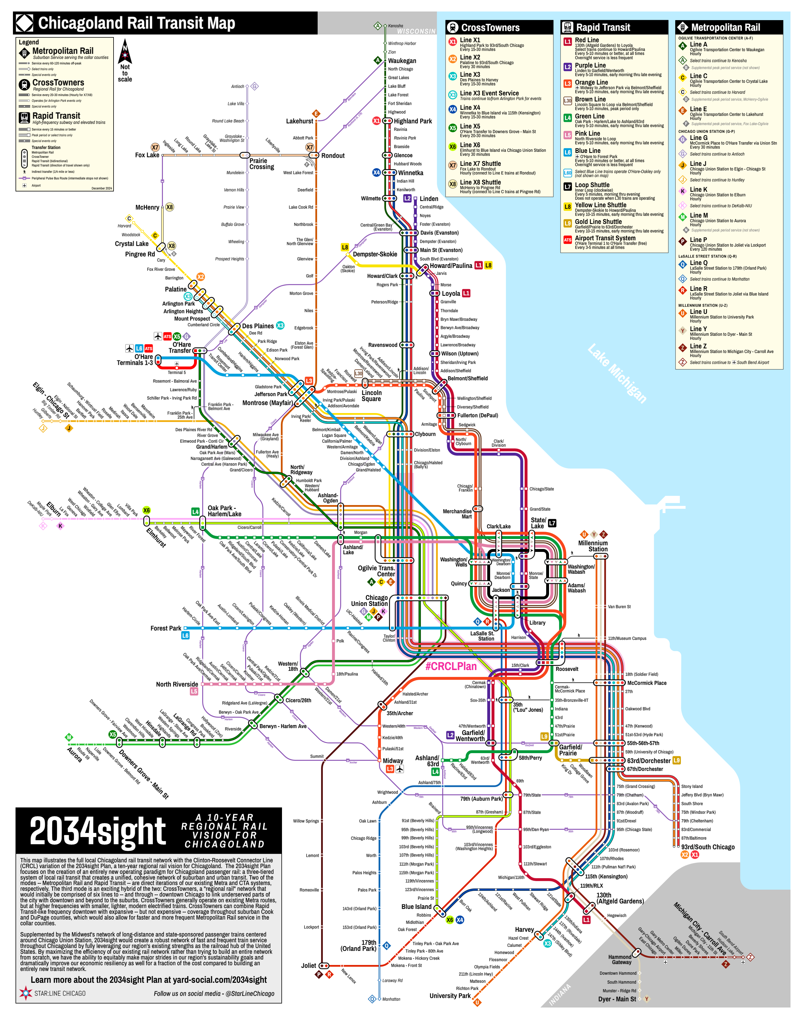
The 2034sight Plan is our initial ambitious — and achievable — ten-year framework to lay the groundwork to modernize Chicagoland’s existing local passenger rail system to create an efficient, effective public transit network that expands regional mobility, enhances regional equity, and puts Chicagoland on a more sustainable path to achieve our environmental goals in a cost-effective manner. In the nearly two years since 2034sight was first published, however, the world has taken some turns: the transit fiscal cliff looms larger, governance reform still remains an open question, incredible amounts of uncertainty are coming from the federal level, and the CTA has pegged the cost of above-ground ‘L’ extensions at a billion dollars a mile — and counting.
As a result, we’re now offering up an alternate vision for CrossTowner regional rail service: the CRCL Plan. Like 2034sight, the CRCL Plan strategically leverages Chicagoland’s existing rail network to provide a new, six-line regional rail system serving over 140 stations to dramatically improve transit options throughout the city and suburbs, ranging from historically-disinvested communities on the South and West Sides to major job and residential centers like the West Loop, Evanston, Arlington Heights, O’Hare, and more; unlike 2034sight, however, we can do it all with only about half as much new tunneling.
Tiers of Service
2034sight and the CRCL Plan both focus on the same three types of train service throughout Chicagoland:
- Metropolitan Rail: the un-portmanteau-ed version of Metra, the CRCL Plan’s Metropolitan Rail service operates very similarly to today’s Metra suburban train service, with trips connecting the suburbs to downtown throughout the day, including with additional service during the busiest times of the day. However, the CRCL Plan streamlines this service by reducing the need to serve as many stations in the city and inner suburbs, allowing suburban trains to lower trip times and with more predictable stopping patterns to make service faster and more frequent throughout Chicagoland.
- Rapid Transit: the more formal name for the existing ‘L’ network in Chicago and some inner suburbs, the CRCL Plan includes only relatively modest changes to the ‘L’ itself, but creates a whole new network of service to dramatically expand the reach of rail transit in the City of Chicago, vastly increasing the reach of our existing Rapid Transit network for a fraction of the cost of building new lines or continuing to expand existing lines further into suburbia.
- CrossTowners: the crux of the CRCL Plan, CrossTowners are a new-to-Chicagoland type and style of train service. Similar to “S-bahn” service in central Europe or “RER” service in France, CrossTowners are a hybrid between Metropolitan Rail and Rapid Transit. Operating on existing suburban railroads, the CrossTowners would be linked together to “thru-run” downtown Chicago on “interlined” (overlapping) routes that would also provide much higher frequency service for many parts of the city and inner suburbs that are far from existing ‘L’ Rapid Transit service.
Benefits
- Regional rail allows Chicagoland to more efficiently use our existing rail network. By “thru-routing”, or connecting these lines straight through downtown instead of continuing to have suburban trains terminate at the downtown stations, trains can operate straight through the heart of the city at higher frequencies, connecting neighborhoods and inner suburbs like never before, all for a fraction of the cost of new ‘L’ Rapid Transit lines.
- Interlining provides Rapid Transit headways with Metropolitan Rail frequencies. While half-hour headways sound relatively modest — and for suburban areas, still a substantial improvement than the current hourly or worse frequencies — by having numerous lines overlap, these trains can function similar to a Rapid Transit line through the city. For instance, even as each individual line would run only twice an hour, through the downtown tunnel four lines overlap, providing 7.5-minute average headways, better than many CTA lines during off-peak periods. Additionally, with lines doubling up through much of the city, wide swaths of Chicago that are currently far from ‘L’ service like Grand Crossing, South Shore, and Edison Park would have service every 15 minutes, all day long.
- Separating suburban services between “inner” and “outer” zones speeds up trips for everyone. With more frequent train service on the inner parts of the suburban rail network, other Metropolitan Rail trains can skip more stops more often, reducing trip times and increasing frequencies even out in the collar counties. Almost every suburban train is an express train with the CRCL Plan.
- Good jobs for Chicagoland workers, and good transit to connect more Chicagolanders to more jobs throughout the region. The CRCL Plan still calls for some pretty substantial investments in new infrastructure, but unlike endless highway maintenance and widening projects, the CRCL Plan creates a more environmentally-sustainable transportation system for all of us. Clean, green, modern jobs to create new neighborhood-to-neighborhood, suburb-to-suburb links throughout Chicagoland.
- Equity, with efficiency. The transit benefits of the CRCL Plan would be overwhelmingly targeted at historically-disinvested communities on Chicago’s South and West Sides, dramatically enhancing transit equity with single-seat, fast and frequent rail transit trips from the Far South Side to the West Loop, Evanston, Arlington Heights and more. Additionally, huge swaths of the West Side and west suburban Cook County will also see improvements with more frequent local trains along the Milwaukee West and Union Pacific West lines. However, this isn’t just a jobs program: by strategically targeting investments to improve on our existing Chicagoland rail network, the CRCL Plan provides taxpayers with a maximum return on their investment by creating new ways to operate our existing network far more efficiently rather than building a totally new transit network from scratch — and for a smaller price tag than 2034sight.
A Three-Phase Process to Regional Rail
There are three basic phases to the plan:
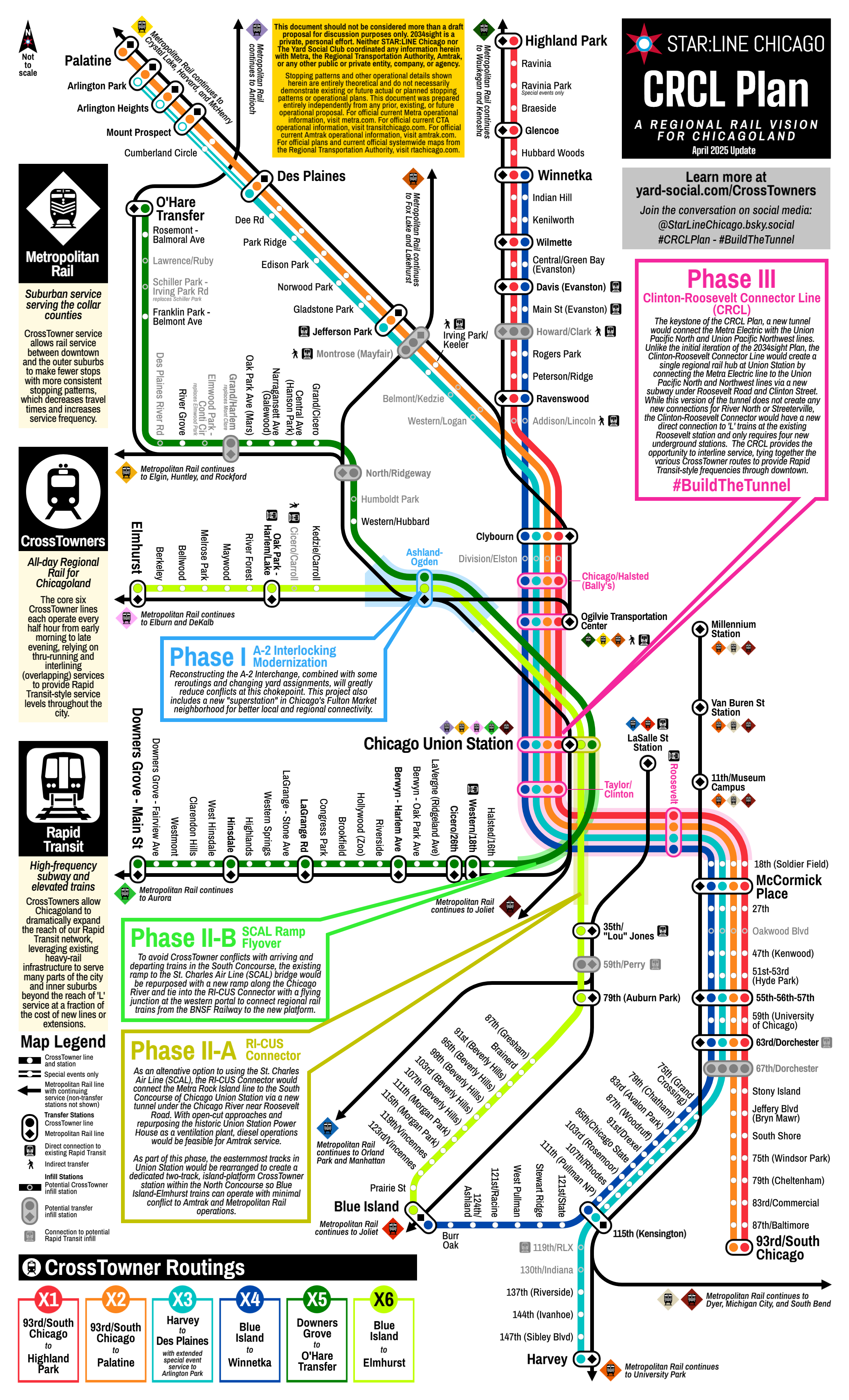
- Phase I: Decongest Metra’s busy “A-2” interlocking. Chicago Union Station, already one of Metra’s primary hubs of operations and Amtrak’s busiest station outside of the Northeast Corridor, is a huge asset to our regional transportation system. However, it is not as efficient or effective as it could be, due mostly to historical quirks: as a dual-stub station, trains generally can only go to — but not through — Chicago Union Station, and trains from the south need to take circuitous routings through Chicago to access the station. Additionally, from the north, trains must also pass through a busy at-grade interlocking junction known as A-2 near Western Avenue where trains heading to/from the Ogilvie Transportation Center must cross trains heading to/from Chicago Union Station. Phase I of the CRCL Plan is already underway at a high level. as Metra has preliminarily discussed modifications to A-2 including a new Fulton Market infill station. However, decongesting the A-2 interlocking is an important first step to providing for more frequent train service on the Union Pacific West and North Central Service main lines without negatively impacting existing Metra and Amtrak service.
- Phase II: Thru-run Chicago Union Station.
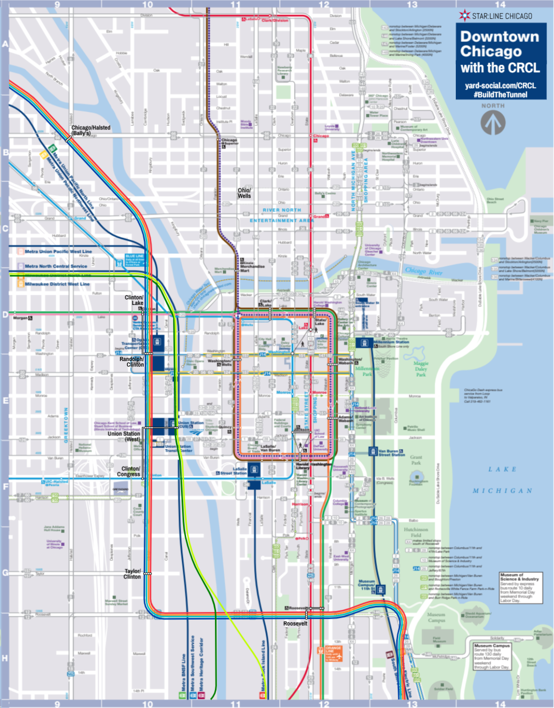
- Phase II-A: RI-CUS Connector — Chicago Union Station is famously set up as a dual-stub station, where trains can approach and depart Union Station from either the north or the south, but generally speaking they have to go out the way they came in, as most of the tracks terminate at the lower-level pedestrian concourse. There are some tracks at the eastern edge of the station that do connect both the North and South Concourses, but only a single track is currently equipped with a platform. Additionally, previous plans to provide proper thru-running at Chicago Union Station rely on the St. Charles Air Line (SCAL) bridge over the Chicago River and connections via active Canadian National freight tracks that also happen to cross the Rock Island at-grade just east of the bridge. In lieu of utilizing the SCAL, the CRCL Plan calls for a new connection between the Rock Island and Chicago Union Station by going under the Chicago River diagonally (on a northwest-to-southeast alignment) near Roosevelt Road. However, this connection may only require a short amount of actual tunneling: the approach on the east end could be an open-cut through the vacant site at The 78, with the western approach similarly an open cut adjacent to Amtrak’s existing yard south of Union Station. (By using an open cut and only a short segment of true tunnel, this connection could also accommodate Amtrak diesel trains.) This improvement would be paired with a new island platform on the Union Station thru-tracks along the Chicago River in the station’s North Concourse. Depending on design limitations, this island platform can also serve as a long-desired direct connection between Union Station and the Ogilvie Transportation Center via vertical circulation in the old City News Building.
- Phase II-B: SCAL Ramp Flyover — Unlike 2034sight, the CRCL Plan calls for connecting the BNSF Railway to Metra’s NCS line via the new island platform discussed in Phase II-A. However, this sets up some potential significant conflicts as trains to and from Downers Grove and Aurora would need to cross the Union Station approach tracks to frequently access the riverside thru tracks. Since the RI-CUS Connector tunnel eliminates the need to connect the SCAL bridge to Chicago Union Station, Phase II-B of the CRCL Plan would repurpose the existing western approach to the SCAL bridge as a new flyover ramp over the Union Station southern approach and Amtrak’s yard, curving and connecting to the Union Station approach tracks near Roosevelt Road. This ramp and alignment also forms a natural “flying junction” with the RI-CUS Connector (where Union Station-bound trains do not need to cross Rock Island-bound trains at-grade), further reducing conflicts for CrossTowner service.
- Phase III: Build the tunnel. The final phase in the CRCL Plan would be to construct the eponymous Clinton-Roosevelt Connector Line (CRCL) tunnel to link the Metra Electric to the Union Pacific North and Northwest lines. Similar to the 2034sight Phase III tunnel, CRCL uses the existing underutilized freight yard near the Bally’s Casino site at Chicago/Halsted to connect to the UP-N/NW lines, then travels under Clinton Street through the West Loop with transfers and connections to the CTA, Ogilvie Transportation Center, and Chicago Union Station; however, rather than connecting to the BNSF Railway, or tying into the SCAL bridge, CRCL would curve and follow Roosevelt Road east to the Metra Electric, with a transfer station at the Roosevelt CTA station serving the Red, Orange, and Green Lines.
What’s This Going to Cost?!
Like 2034sight, the CRCL Plan would be a megaproject. Detailed cost estimates and designs have not yet been created for either vision, but we can use similar high-level overviews. (Note: to maintain consistency, the CRCL Plan cost estimates seen below use the same 2024 U.S. Dollar estimates as the estimates on the 2034sight page.)
| Phase/Project | Cost Estimate | Notes and Sources |
| Phase I: A-2 Improvements and Fulton Market Superstation | $1.50 billion | 2021 CDOT/DPD/Metra community meeting, inflation adjusted. Lower bound used, but likely still an overestimate as Metra’s cost includes a new flyover structure, which would largely be made irrelevant by 2034sight’s proposed reroutings. |
| Phase II-A: RI-CUS Connector | $1.20 billion | Assuming $1B/mile for approximately 1.1 miles, based on a $900M/mile total final cost for Los Angeles’ recently-opened Regional Connector. This is likely a conservative estimate as over 4,000 feet of the route would be an open-cut, with only about 800 feet of true tunnel. An additional $100 million was added to convert the historic Union Station Power House into a ventilation plant to allow for diesel operations in the tunnel. |
| Phase II-B: SCAL Ramp Flyover | $650 million ($0.65 billion) | The SCAL Ramp Flyover would only require about a half-mile of new structure, which at Red Line Extension (which includes electrification) estimates of $1.02B/mile yields a cost estimate of $510 million. However, the existing ramp may require additional upgrades to handle faster and more frequent service, and the ramp will require at least a portion of the large defunct northern approach to be dismantled and removed. |
| Phase III: Clinton-Roosevelt Connector Line (CRCL) | $4.50 billion | Same initial $1B/mile estimate as Phase II-A above for roughly 3.3 miles of tunnel; however, engineering of the curves near the One Museum Place residential skyscrapers, as well as needing to tunnel under the RI-CUS Connector at the Chicago River, may complicate engineering and construction. Also added additional costs of $200 million each for more complicated stations with direct connectivity with CTA subways (Roosevelt Red and Clinton Blue). |
| Rolling stock | $1.00 billion | Rough estimate; mostly a conservative placeholder. Metra is purchasing a lighter, modern fleet of 16 trainsets from Stadler that could theoretically perform CrossTowner service for a cost of $336 million, but a much larger fleet would likely be required for full service. |
| Station upgrades and new infill stations | $1.00 billion | Rough estimate and variable based on number and location of new infill stations. |
| Total Cost, 2024 dollars | $9.85 billion | Successful federal grant applications would generally cover up to 50% of the total cost of the project. |
While nearly $10 billion is certainly nothing to sneeze at, even at very rough estimates the CRCL Plan would be at least 15% cheaper than 2034sight, with less disruptive construction than 2034sight’s routing through River North, Streeterville, and Lakeshore East. It’s also worth contextualizing what this project would provide to Chicagoland: for less than double the cost of the CTA’s ongoing Red Line Extension (now up to $5.75 billion, so far), Chicagoland could have a new, 140+ station network that spans the city and much of Suburban Cook County while providing significant improvements to transit trips throughout all six Chicagoland counties, including Rapid Transit-style train frequencies to numerous historically-disadvantaged neighborhoods throughout Chicagoland.
What’s Next?
Whether Chicagoland’s regional rail vision ends up looking more like 2034sight, or more like the CRCL Plan, or some totally different third option, in the immediate future the critical path lies on bridging the fiscal cliff, as well as governance reforms that move Chicagoland in a direction where we focus on tackling transit as a truly regional effort, rather than continuing to pit the city vs. the suburbs for resources and representation.
Regardless, now is the time to focus on the kinds of strategic investments the two CrossTowner plans identify that will allow Chicagoland to emerge from the pandemic era with a modern, cost-effective transit network. Ultimately, CrossTowners can simply be a road map that can align existing projects and priorities from a variety of agencies — CTA’s Red Line Extension, Metra’s transition to regional rail, Amtrak’s regional improvements and enhancements — with a unified vision and path forward, avoiding the siloed approaches and inefficiencies of the past to finally build a 21st-Century rail transit network for Chicagoland.
If proper regional rail sounds like a good idea to you, talk to your local elected representatives and spread the word. Visit our regional rail gateway at yard-social.com/CrossTowners, and we have a handy PDF brochure that summarize the plans and provides more detail about the benefits of regional rail.
You can also get social with StarLineChicago on Twitter, Threads, BlueSky, and Instagram. (#2034sight #CRCLPlan #BuildTheTunnel)
If you have questions about these plans, feel free to contact us through this website.
Maps and Exhibits
All maps can be enlarged by clicking on the image.
System Map
Note that this map includes several other ancillary projects that are not included in the core cost scope of the CrossTowner regional rail visions, including suburban rail shuttles in McHenry and Fox Lake; a Brown Line extension to Mayfair; a shuttle service and ‘L’ extension to Jackson Park; and all-day Purple Line service via the State Street Subway.
Project Site Map

RTA-STyle Map
Frequency Chart
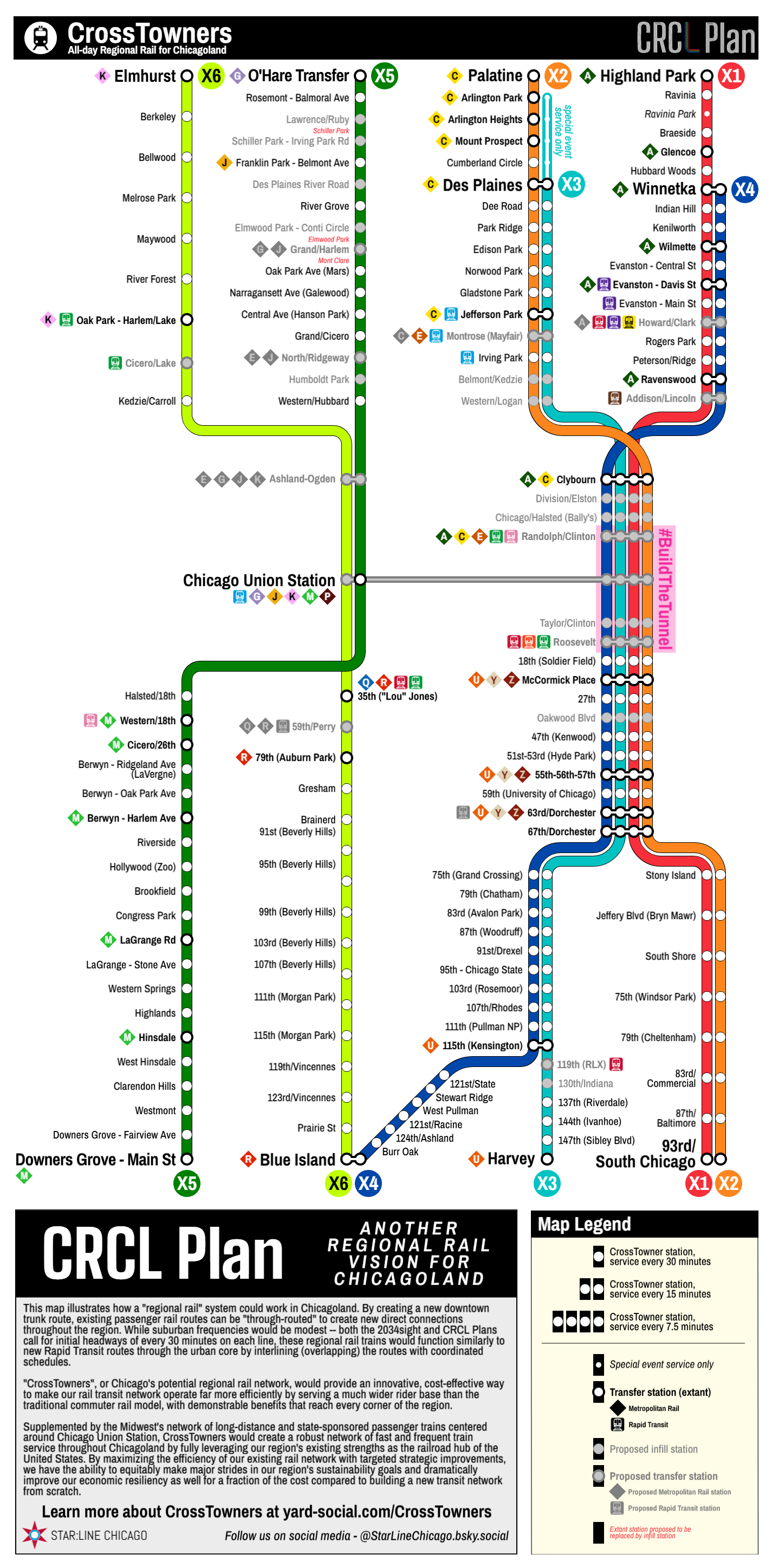
Suburban Service Map

2034sight + CRCL Plan
The CRCL Plan is forward-compatible with the original 2034sight Plan, as the Ohio-Columbus Tunnel can still be constructed at a later date either as a bypass/alternate tunnel, or as a standalone circulator system as shown here.

More Information
For more information about the plan, and to download a printable information sheet, click here. You can also read the original 2034sight Plan post on the Diverging Approach blog.

#BuildTheTunnel