While the Bears continue to suck most of the political oxygen out of the room with their current will-they-or-won’t-they soap opera between Arlington Heights and Indiana, thankfully the city still has a few major irons in the fire regardless of wherever the McCaskeys end up deciding to exploit build.
All eyes might be on Soldier Field, but just across DuSable Lake Shore Drive lies another potential megaproject site: ONE Central. A true megaproject, ONE Central was first pitched back in 2019 to add a bunch of skyscrapers over the Metra Electric tracks between McCormick Place and the Field Museum. With a site spitting distance from the Lake and adjacent to the burgeoning South Loop neighborhood, a megaproject to add thousands of commercial, office, and residential tenants on railroad air rights seems to make a lot of sense… unless the pedestal to build it on ends up costing $6.5 billion.
Of course, any rational developer would try their hardest to get the state to pay for that instead of having it come out against their bottom line, and the best way for a developer to make a case for state support to build that sandbox for them to play in is to play up the public benefits of the project. In this case, ONE Central’s pedestal wasn’t simply the base for supertall skyscrapers, but rather it would actually be a world-class transit center for CTA, Metra, NICTD, Amtrak, and anyone else the developer could think of. As a result, the General Assembly passed the Public-Private Partnership for Civic and Transit Infrastructure Act, authorizing the State of Illinois to contribute nearly $6.5 billion for the project.
Unfortunately for the project, transit and transportation advocates were extremely skeptical of ONE Central’s transit-oriented claims, and many of the initial transit projects themselves were dubious: the project would include an ‘L’ branch from somewhere in the vicinity of 17th Junction (where Midway-bound Orange Line trains currently split off from the Green Line), but with no clear indication of how the service would actually operate: is it a new line? Are we adding a branch to the Orange Line or Green Line or Red Line or something totally different? Would these trains go to the Loop or to Midway? Is anything actually constructable over — or under — Canadian National’s freight tracks? Would additional properties beyond the project envelope be needed to tie into the existing network?
On the commuter rail side, the project called for reverse-branching Metra’s busiest line (BNSF), meaning half of Metra’s busiest trains would now miss downtown entirely, cutting across the St. Charles Air Line and terminating at ONE Central rather than Union Station. This would almost certainly be a non-starter for Metra (to say nothing of the significant additional amounts of operating funding, logistics, and additional infrastructure needed to turn and/or lay over rush hour trains somewhere near McCormick Place, also not included within ONE Central’s footprint), and for the suburban communities along the BNSF.
Many readers may also remember that in 2020, there was a global pandemic that dramatically upended day-to-day lifestyles and work patterns in urban cores around the world. Additionally, with the Bears announcing their intent to vacate Soldier Field, the fundamentals of the ONE Central project became even shakier. As part of the state’s due diligence, Illinois commissioned a feasibility study on the project, which was completed in 2025. The results of the study convinced Gov. JB Pritzker to pull the plug on public support for the project entirely. Today, the OneCentralChicago.com website is still live but only consists of a static “coming soon” page that appears to have not been updated since 2023.
Alas, today ONE Central remains a megaproject in search of a megaproject.
A Brief Post-Mortem
Let’s dive back into the latest transit proposal for ONE Central. Prior to the feasibility study’s initialization, ONE Central modified their proposal to drastically lower the public-facing cost to an estimated $2.75 billion, or a 58% decrease from the previous $6.5B price tag. The modified proposal relies on far less decking over the Metra tracks, with more of the key vertical infrastructure on terra firma rather than a bridge deck by shoving the Metra tracks and the McCormick Busway1 as far west as possible within the site envelope.
“Civic Build” ONE Central proposal as published in the 2025 Feasibility Study (that is publicly available online).
In addition to reducing the amount of decking required, the latest ONE Central proposal also gives up any direct CTA ‘L’ connection, now relying on a “CHI-Line Rail Shuttle”, a train that would connect ONE Central to the Red Line (a new transfer station in the southern portion of The 78 is proposed, but not included in the cost) and to Union Station.
“CHI-Line Shuttle” concept, with trains connecting ONE Central to the Michael Reese Hospital site, The 78 (with a Red Line connection at a future infill station), and Union Station. (Source: Feasibility Study)
The feasibility study notes some potential impacts that could negatively impact the potential success of the CHI-Line Shuttle: namely, the concept relies upon Amtrak’s completion of CHIP, being able to use the St. Charles Air Line bridge, and negating potential conflicts with Metra at the Rock Island crossing as well as freight traffic on the Canadian National line.
Not mentioned in the feasibility study but also a concern: whether a Red Line station at The 78 is financially (and physically) feasible. Where the CHI-Line Shuttle would cross the Red Line, the Red Line is on a downward curving slope between the subway portal near 16th Street and the Roosevelt subway station. Notably, some local neighborhood groups have shifted towards advocating for an infill Orange Line elevated station rather than a Red Line subway station.
Can’t help but wonder if there’s an alternative to the CHI-Line Shuttle that could avoid those potential pitfalls…
Zooming Out
Let’s quickly take a look at some of the other megaprojects discussed in this post:
Strategically investing in infrastructure to support and leverage private investment is a smart move for the public sector, especially if those infrastructure investments are proactively coordinated, seamlessly integrated with the regional network, and will provide all-day, seven-days-a-week, year-round benefits to Chicagoland residents, workers, shoppers, and visitors.
ONE Central’s transportation proposals didn’t pencil out at least partially because they largely failed to account for regional benefits. But, if the CHI-Line Shuttle instead looked something like this…
…and if these trains connected not only ONE Central and Union Station but also:
Foundry Park (Clybourn)
and The 78 (Roosevelt)
and the Quantum Park (87th/Baltimore)
and The 1901 Project (Ashland-Ogden)
and Soldier Field (18th)
and Arlington Park (Arlington Park)
(and Northwestern University)
(and O’Hare)
(and the University of Chicago)
(and Sox Park)
(and… well, you get the idea.)
Regional rail is the megaproject’s megaproject: with a handful of strategic projects to connect the infrastructure we already have, we can stretch our public investments far beyond what was previously possible to better leverage private-sector capital throughout all of northeastern Illinois.
Strategic, transformative, ambitious-yet-attainable transit investments to unlock Chicagoland.
It’s time for CrossTowner regional rail. It’s time to #BuildTheTunnel.
The revised transit proposal includes the previous “CHI-Line Circulator” bus corridor concept utilizing the McCormick Busway to connect ONE Central to Lakeshore East. In the interest of brevity, this post does not detail the Circulator, but additional detail can be found on pages 14-16 of the feasibility study. ↩︎
It can be challenging, however, to envision how such a system could be crafted, developed, built, and operated; indeed, it is one of the most common questions we’ve received. There are multiple existing constraints that need to be identified and mitigated, and major capital projects that would need to be built. The Chicago Terminal, as railroaders generally refer to the Chicagoland rail network, is an incredibly complex place to operate trains.
To this end, this post will attempt to identify a potentially-plausible phased approach to get Chicagoland from today to the regional rail network our region deserves. The service plans and proposals included herein are, of course, entirely unofficial: the CrossTowner regional rail proposal has always been, and continues to be, an exercise in imagining what could be rather than an official or professional regional plan. These plans have not been vetted by any of Chicagoland’s transit agencies, and rely exclusively on publicly-available materials and observations. Much further study and planning would be required before any implementation begins, but this post is an attempt to show how we could eat the proverbial elephant one bite at a time.
Before We Begin
Some housekeeping before we get into the details: this post will rely heavily on maps that document different phased implementation components of the larger CrossTowner regional rail network vision. In some cases, the phases are irrelevant: some infill1 stations, for instance, could be constructed at any time (or not at all). In other cases, it may make sense to move certain components up or push them back based on cost, constructability, political realities, and so on.
These maps also use a standardized “netgraph” approach to displaying service frequencies: each line represents one round-trip per hour. This allows an easier way to communicate average headways, or times between trains. Note, however, that these are averages: more detailed service planning would be required to determine more realistic schedules. Additionally, due to the realities of needing to balance local service with express service in some cases on shared tracks, perfectly-balanced headways all-day may not be entirely feasible.
Note that these maps all show proposed off-peak service levels. Additional trains would operate during peak periods, likely including Metra’s typical battery of suburban express services; these trains are not shown.
A quick mathematics cheat sheet:
One line = one train per hour = 60 minutes between trains
Two parallel lines = two trains per hour = 30 minutes between trains
Three parallel lines = three trains per hour = 20 minutes between trains
Four parallel lines = four trains per hour = 15 minutes between trains
Five parallel lines = five trains per hour = 12 minutes between trains
Six parallel lines = six trains per hour = 10 minutes between trains
Eight parallel lines = eight trains per hour = 7.5 minutes between trains
Thinner lines indicate lines that operate less than hourly; these stations are shown “inverted” (a solid-colored station with a white border, rather than a white circle with a colored border). Additionally, lines in future phases are shown by their “Yard Social Standard” identification scheme that is also shown on other CrossTowner materials. The below “baseline” map provides a comparison to that scheme and the existing line naming system.
The Regional Rail Road Map
Baseline: The Post-Commuter Era
We begin with the “Post-Commuter” era: Metra has already committed to transitioning their fundamental operating model from “commuter rail” to “regional rail”. Preliminarily, this can be best summarized as “hourly everywhere”: while some level of peak-period focus is warranted based on present ridership, the larger goal is to provide bi-directional all-day service throughout the service area. At present, Metra has been activelymoving towards hourly headways wherever possible.
Unfortunately, that is not feasible everywhere: freight conflicts at numerous locations on the Heritage Corridor and SouthWest Service, as well as some single-track chokepoints on the North Central Service, will make all-day hourly service challenging from an infrastructure perspective. Additionally, on most lines Metra remains at the whims of freight railroads that either control the lines outright or exercise a high degree of autonomy that prevents Metra from easily increasing service. These constraints are one of the primary reasons why Metra cannot easily add additional service, and they need to be a political priority for our region as the NITA era begins.
For the purposes of this post, let’s assume that they can be mitigated to some degree: Metra will need to continue to share tracks with freight traffic, and will need to ensure freight railroads can still reasonably operate throughout the day, but where freight traffic is lighter, Metra and the freights could come to some sort of agreement to add service.
For reference, here is a recent CMAP freight rail volume map, as of 2023.
As Chicagoland takes concrete steps to move towards a proper “regional rail” paradigm, the first step would be adding additional trains to the central part of the region, where population densities are more supportive of increased service on some of Metra’s busiest routes. While “hourly everywhere” remains the goal for the region as a whole, supplemental service would be offered such that frequencies would improve to half-hourly closer to the urban core, while also beginning to provide all-day (hourly) service to some current peak-only stations, especially along the BNSF and Milwaukee West lines.
Supplemental hourly trains (to create half-hourly headways) would begin running on the Union Pacific North (“A/B”), Union Pacific Northwest (“C/D”), BNSF (“M/N”), Rock Island Beverly Branch (“S”), and Metra Electric South Chicago (“W”) lines. Supplemental trains would also operate on the Metra Electric Main Line and Blue Island Branch (“V”), to provide half-hourly frequencies north of Kensington and hourly service on the Blue Island Branch. Combined with half-hourly service on the South Chicago Branch, this would provide 15-minute service between Hyde Park and Millennium Station, not including Main Line (“U”) and South Shore Line (“Z”) express trains.
A “new” line would also be created: Line “H” would serve as the supplemental hourly local pattern combining Milwaukee West and North Central Service stations between Chicago Union Station and O’Hare Transfer. Line “H” would also relieve the NCS of the need to make stops at Franklin Park, Schiller Park, and Rosemont, speeding trains up from the northern suburbs as well as speeding up express trains to O’Hare.
Following Phase I, most Metra stations in Chicago and some inner suburbs would be able to provide half-hourly service all day long, with only seven additional trains per hour region-wide.
Phase II: Regional Rail
Following the Enhanced Service in Phase I, Phase II would take a stronger step towards a proper “regional rail” network. At a high level, the goals of Phase II are to separate “inner” supplemental service trains from “outer” suburban trains, allowing the latter to run express all day long.2 To allow this, strategic station investments are needed to create better transfer stations — “superstations” — that allow “inner” and “outer” trains to coordinate service, maintaining connectivity throughout the region while speeding up express services. The six “regional rail” lines also now have their own distinct identification, and would likely also use a more modern rolling stock similar to Metra’s forthcoming Stadler FLIRT fleet.
Phase II has six primary infrastructure improvements:
A-2 Modernization and Fulton Market Superstation: Perhaps the most important project in this phase, this effort would reorganize Metra’s complicated A-2 interlocking on the West Side near Western Avenue, minimizing crossing conflicts by re-routing Line “K” (UP-W) trains into Chicago Union Station and Line “E” (MD-N) trains into Ogilvie Transportation Center. This reconfiguration would almost certainly be required before increasing frequencies between Chicago Union Station and O’Hare. This phase would also include a new Fulton Market Superstation to allow transfers and connections, as well as serve a burgeoning part of the city. (This project has been on Metra’s radar for a while.)
Grand/Harlem Superstation: A station consolidation on the Northwest Side would create a contiguous Harlem Avenue bus corridor that connects express and local rail service to O’Hare to two other Metra lines (UP-W at Oak Park and BNSF at Harlem Avenue) as well as two3 CTA ‘L’ lines (Green Line at Harlem/Lake and Blue Line at Harlem-Congress). The full CrossTowner vision includes this bus route as a Pace Pulse corridor that would extend to Summit, then east on Archer/55th to the Orange Line ‘L’ terminal at Midway Airport.
Mayfair Superstation: A new station on Line “C/D” (UP-NW) that would connect with the existing Line “E” (MD-N) Mayfair station and the existing Blue Line Montrose station. While the UP-NW also has Blue Line connections north and south of Mayfair, creating a unified Northwest Side superstation could anchor a future Brown Line western extension, as well as create far easier Amtrak connections between Hiawatha/Borealis/Empire Builder trains and O’Hare Airport via the Blue Line. Thinking far further into the future, a Mayfair superstation could also allow for reuse of the Weber Spur as a transit artery, as well as bookend a northern Cicero Avenue transitway.
75th Street Corridor Improvement Program (CIP): Another project that has been on the books for years, the 75th Street CIP would allow Line “Q” (SWS) trains to connect to LaSalle Street Station instead of Chicago Union Station while also bypassing key freight bottlenecks. While this project would not have a direct impact to the “regional rail” lines, it would be a significant improvement that makes hourly SWS service more feasible.
Kensington Superstation: On the Far South Side, the existing 115th (Kensington) station would be (re-)expanded to (once again) allow for NICTD trains to make stops, supplementing the local/express patterns of the Metra Electric. Additionally, with NICTD operating the new Monon Corridor as an off-peak shuttle operation between Dyer and Hammond Gateway, Monon (Line “Y”) shuttle trains could be extended to the Kensington Superstation, doubling frequencies to Hegewisch.
McCormick Place Superstation: To better serve a major trip generator, as well as to provide another local/express transfer location along the Metra Electric, additional platforms would be added at McCormick Place in advance of future phases and service expansions. These new platforms would also allow special-event services on the express patterns to more easily serve McCormick Place without interfering with all-day local services.
On the North Side, these improvements, combined with three additional round-trips per hour, would allow for the busy “A” (UP-N) and “C” (UP-NW) lines to run express to speed up trips from the north and northwest suburbs, and on the West Side, local Line “H” trains could run twice an hour between Chicago Union Station and O’Hare Transfer to provide more robust all-day transit service connecting working-class neighborhoods to the region’s two largest job centers. The added hourly Line “H” train could also utilize the single existing thru-track at Chicago Union Station to replace the “N” BNSF supplemental pattern, creating a single-seat trip between Metra’s busiest line and O’Hare. Furthermore, with half-hourly service, Line “G” (NCS) trains could skip more stations, providing an early “O’Hare Express” operation between Chicago Union Station and the airport.
Phase III: CUS Thru-Running
The larger regional CrossTowner network starts to take shape in Phase III, when dedicated thru-running tracks at Chicago Union Station are constructed. This improvement can allow for proper thru-running operations at Chicago Union Station for regional rail service at higher frequencies. Combined with Amtrak’s Chicago Hub Improvement Program (CHIP), three primary routes could be implemented:
X5: Building on the work of Phase II, the other hourly Line “H” train would also be thru-run to Downers Grove Main Street and rebranded as the X5 CrossTowner. This change would allow Line “M” (BNSF) trains to run essentially express east of Downers Grove, with stops only at Hinsdale, LaGrange Road, Harlem Avenue, Cicero, and Western.
X6: To create a future unified hub at Chicago Union Station, Line “S” (Beverly Branch) trains would turn off of the Rock Island District to connect with the vacated4 SouthWest Service tracks, run through Chicago Union Station, and provide regional rail service along Line “K” (UP-W). The CrossTowner vision suggests this connection be made through the parking lots of Rate Field, but several alternative options could be feasible and require further study. This route would be rebranded as the X6 CrossTowner.
O’Hare Express (Line “G”): Thru-running Chicago Union Station, combined with fewer stops between downtown and O’Hare for Antioch-bound trains, and improving the St. Charles Air Line (SCAL) bridge over the Chicago River, creates the opportunity to operate an oft-desired airport express service between the McCormick Place Superstation, downtown, and O’Hare. Unlike other airport express operations, however, this would functionally be just an extension of Line “G” (NCS) suburban trains.56 While not officially a CrossTowner line, this service would be an important component of the larger system and would provide single-transfer connections from the Metra Electric lines to Chicago Union Station and O’Hare prior to the construction of the tunnel.
Phase IV: #BuildTheTunnel
By the time we get to building the tunnel, operationally it ends up being an extremely straightforward enhancement. The tunnel gets built under Clinton Street and Roosevelt Road, and each of the four remaining regional rail lines (“B”, “D”, “V”, and “W”) simply continue through the tunnel and out to regional rail lines on the other side as CrossTowners. Doing so halves headways on the rest of the regional rail network, while expanding half-hourly service further out into the suburbs. Within the tunnel itself, and indeed down the entire “trunk” between Clybourn and Hyde Park, CrossTowner trains now operate every 7.5 minutes, and every 15 minutes as far as Kensington, South Chicago, Winnetka, and Des Plaines.
The tunnel would greatly enhance regional intermodal connectivity with stations at Randolph/Clinton (connecting to Green and Pink Line ‘L’ trains at the existing Clinton/Lake station and Metra trains at Ogilvie), Chicago Union Station (connecting to Blue Line ‘L’ trains at the existing Clinton/Congress station as well as Amtrak, Metra, X5 and X6 trains at the station), Taylor/Clinton (to seed a new transit-oriented development neighborhood), and Roosevelt (connecting to Red, Orange, and Green Line ‘L’ trains at the existing Roosevelt station).
The core CrossTowner network is now complete.
Beyond The Tunnel
While the initial vision would be complete, that doesn’t mean there wouldn’t be additional opportunities for expansion. With no freight conflicts on the Metra Electric District, additional regional rail routes could be added later; more frequent service to O’Hare, or expanding regional rail to the Milwaukee North, or entirely new services could be added in the future. The original 2034sight Plan calls for a tunnel under Ohio Street and Columbus Drive, a corridor that remains ideal for additional high-frequency, high-capacity transit options to serve River North, Streeterville, and Lakeshore East. This alignment could also provide single-seat trips from the Far South Side to O’Hare more feasibly, and closer to downtown the Ohio-Columbus tunnel is bookended at each end by “superstations” to provide universal connectivity between lines as needed. Rather than precluding these service alternatives, the CrossTowner vision is intentionally open-ended and forward-compatible for the continued growth of Chicagoland’s transit network.
CrossTowner regional rail network map, showing 2034sight and CRCL Plan enhancements.
The time is now
As the new Northern Illinois Transit Authority (NITA) launches this summer, Chicagoland transit is in a position to not only survive but to thrive on regional coordination, integration, and bold visions for the future. Nothing worth having is ever easy, but CrossTowner regional rail can be the bold, achievable, pragmatic vision Chicagoland needs to once again shoot for the stars.
It’s time to unlock our regional potential. It’s time for regional rail.
Justification for individual infill stations are generally not included in this post, but additional information will eventually be posted somewhere. These posts are long enough without getting truly into the weeds. ↩︎
Ideally three in the more distant future with a Pink Line extension to North Riverside. ↩︎
Metra operations would have been moved off of this segment following completion of the 75th Street CIP, but Amtrak and occasional freight traffic would still likely use portions of the route. ↩︎
Amtrak could plausibly extend Midwest intercity trains to O’Hare on the same routing; however, there is potential for that to be a net-negative at a local Chicagoland level if that operation would come at the cost of more frequent suburban service on the NCS. ↩︎
It is not shown on these maps, but O’Hare Express (Line “G”) trains could also serve the proposed One Central megaproject near 18th Street in lieu of that project’s proposed reverse-branching of the BNSF. ↩︎
For nearly three years now, this blog has been beating the drum on “regional rail” and why we need to “build the tunnel”, but it may be helpful to take a step back and discuss at a more basic level what “regional rail” is and how it could work in a Chicago context.1
Regional rail is a “keystone” vision that would create a unified backbone for a modern regional transit network, with truly-regional benefits. While definitions of “regional rail” may differ, the CrossTowner proposal is fundamentally a third transit mode that is effectively overlaid on the existing Metra network, plus creating new strategic downtown connections.
In the interest of level-setting, at a conceptual level “thru-running” regional rail works by creating one or more trunk lines to connect existing Metra lines via downtown. As more branches converge into the trunk line, train services overlap and the individual lines contribute to higher frequencies through the trunk, so riders who are heading from one trunk station to another do not need to worry about which train is which since they all make the same stops. (For instance, on the existing Metra network, a rider who boards at the Western Avenue station near Hubbard Street does not care whether their inbound train is MD-N or MD-W or NCS since all the trains go to Union Station regardless.) In addition to providing additional connections to other parts of downtown for “traditional” commuters, rather than making all riders get off at separate terminals just outside of the Loop, new longer-distance direct trips are also created, expanding the reach of the network to a wider potential audience of transit users.
Fundamentally there are two different models of regional rail networks.
Philly-style: one tunnel wit commuter rail schedules
In Philadelphia, SEPTA operates regional rail through their Center City Commuter Connection tunnel, which opened in 1984. This connection created a unified network by connecting the Pennsylvania Railroad’s historic commuter lines that entered Center City from the west with the Reading Railroad’s commuter lines that entered Center City from the north.
Excerpt from the Wikipedia SEPTA Regional Rail map. The Center City Commuter Connection stations are shown as black circles; former PRR routes are shown in shades of red; and former Reading Railroad routes are shown in shades of blue. Note that lines do not necessarily correlate on both sides of the tunnel.
While the Center City Commuter Connection allows for all commuters to access multiple stations in Center City, SEPTA still fundamentally operates the system as a commuter railroad: off-peak headways are still high (generally hourly), and the central “trunk” is relatively short. Furthermore, through-routes are not consistent throughout the day: riders traveling beyond Center City still need to regularly consult printed schedules to determine which trains end up where, with most intra-regional trips still requiring a coordinated transfer.
SEPTA West Trenton Line inbound weekday schedule. All trains make the Center City stops (Jefferson Station, Suburban Station, 30th Street) but about half the trains terminate at 30th Street with the other half split amongst the Thorndale (THO/MAL), Wawa (MED), and Newark (NWK/WIL) lines.
Prost: A toast to the Munich S-Bahn
On the other side of the planet is the Munich S-Bahn, one of the oldest “modern” post-war regional rail operations. Facing a tight six-year deadline after being awarded the 1972 Olympics in 1966, Munich converted their existing regionalbahn regional train network into an S-Bahn, or “city rapid railway”. The Munich S-Bahn was created by building a tunnel through central Munich connecting the city’s existing Central Station and East Station. This tunnel serves as a trunk in which the various lines converge to provide a high-frequency east-west transit link through the urban core.
Munich S-Bahn network map, connected via a downtown tunnel. S-Bahn regional routes are consistently balanced (e.g., the S3 trains from Mammendorf or Malsach will always continue through the tunnel and end up at Deisenhofen or Holzkirchen). S-Bahn trains generally share tracks with regional trains that continue beyond the Munich metropolitan area.
Excerpt from an unofficial German rail map showing intercity, regionalbahn, and S-Bahn lines in Munich. Most regionalbahn lines still terminate at a single location (Munich Hauptbahnhof (Central Station)), with S-Bahn trains making local stops to allow regionalbahn trains to operate faster.
Unlike in Philadelphia, beyond central Munich the S-Bahn network serves as an overlay of the existing regionalbahn (RB) lines, which largely continue to operate directly into Central Station and terminate there, similar to how Metra trains today terminate at Union Station, or Ogilvie Transportation Center, or LaSalle Street Station, or Millennium Station. Munich’s S-Bahn branches are also consistently matched: the same line in the west will always connect to the same line in the east, all day long.
Munich S-Bahn network map showing the various individual lines that comprise the east-west trunk line. While some lines branch further out and some trains may also short-turn to better match headways and ridership demand, the core of the system is built around seven lines converging to collectively operate at high frequencies through a larger segment of the urban core.
The above map helps to demonstrate how this network is fundamentally structured. Each individual line runs at regular intervals bi-directionally throughout the day; as lines converge closer to central Munich, the schedules are coordinated so trains are relatively balanced along the trunk, providing fast and frequent east-west trips through the heart of the city. In central Munich, the strength of the network is the trunk tunnel line between East Station (München Ost[bahnhof]) and Central Station (München H[aupt]b[ahn]h[of]), with the trunk continuing above ground further west. For riders who are traveling between any two stations along this trunk, it doesn’t matter which train they board since they all make all the stops, which allows the trunk to function like a rapid transit line.
Further out, the consistency of each line’s operations better serves riders traveling beyond the urban core. As an example, a rider who boards the S8 line at the Munich Airport (Flughafen München, east end of the yellow line) headed towards Herrsching (west end of the yellow line) will always have a direct connection. Compare this to Philadelphia, where taking the Airport Line in from PHL results in about a coinflip’s chance that the train will not go past Temple University, and also may not pair up with the otherwise-typical Warminster Line pairing during morning rush or in the late evening.
SEPTA Airport Line inbound weekday schedule. About half of Airport Line trains continue to the Warminster Line (WAR), but also occasionally the Norristown Line (MIQ) or Doylestown Line (DOY, LAN), but there’s also about a coin-flip’s chance that the inbound Airport Line train will simply go out of service past Temple University instead.
For these reasons, the CrossTowner vision takes more inspiration from the Munich S-Bahn model.2
CrossTowners for Chicagoland
Here’s a graphic to help highlight some of the benefits of this kind of regional rail network in more of a Chicagoland context, and to illustrate the functionality of such a system as something of a hybrid between the CTA’s rapid transit network and Metra’s commuter3 rail network.
CrossTowner regional rail fills an important “missing middle” role in our existing rail transit network, supplementing existing rapid transit lines and broadly expanding the footprint of neighborhoods with fast and frequent train service, while allowing for existing commuter rail trains to operate at higher speeds with fewer stops all day long.
The “CRCL Plan” variation of the CrossTowner regional rail vision creates a six-line, 140+ station network centered around Union Station by connecting the Union Pacific North and Northwest Lines to the Metra Electric Line via a new tunnel, with additional services providing by creating two new thru-routes at Union Station itself. These lines would operate in addition to existing Metra service, although CrossTowners would also replace Metra service in some areas as well (e.g. the Metra Electric branches).
As we enter the NITA era, it is imperative that we begin planning and operating our transit network with a focus on regionality, and thru-running regional rail on its own provides benefits throughout the entire region:
· For Chicagoans, thru-running regional rail service (assuming a single tunneled connection between the UP-N/NW lines and the Metra Electric) would effectively create a ninth ‘L’ line between Metra’s Clybourn station and Hyde Park with direct connections to at least five existing ‘L’ lines and at least ten existing Metra lines. This trunk also allows for more direct transfers to a wider variety of services (e.g., Far South Siders could take trips to O’Hare simply by changing trains at Union Station rather than walking three blocks between Millennium Station and the Dearborn Subway), so even if a transfer is still required to complete a trip, the “transfer penalty” is far lower.
· In the outer neighborhoods and inner suburbs, regional rail allows for more convenient rail service on existing Metra lines in areas of the city far from even the most optimistic expansions to the ‘L’ network, and specifically improves connections to work centers beyond the Loop (O’Hare, Des Plaines, Evanston, etc.). With regional rail taking a larger role in “radial” rail service, future ‘L’ system expansions can focus on building a stronger urban network and shifting away from a strict hub-and-spoke model (e.g., building the Circle Line or the Mid-City Transitway).
· In the collar counties, regional rail operations allow Metra to operate more all-day express service on their busiest lines since regional rail trains will serve most of the local stops. In other words, even though CrossTowners themselves may not reach far into the collar counties, they allow for existing service to run at higher speeds with fewer stops, still providing a direct benefit.
NITA will undoubtedly have its hands full for the first few years in setting the foundation for the 21st-Century transit network Chicagoland deserves, whether that’s reimagining the bus network or establishing service standards or determining the best key performance indicators to track the progress of each agency and the network as a whole. Regional rail is a terrific example of what could be possible for our region as NITA gets established.
As we embrace a more regional perspective to how we plan, operate, and fund our transit network, having an ambitious-yet-attainable “moonshot” project to tie Chicagoland together will be an important contribution to demonstrating the additional value NITA can provide to the entire region.
While Metra has publicly committed to transitioning to a “regional rail” model, and while the NITA legislation will also hold them to that promise, Metra’s definition generally boils down to “run more trains”. While this blog will be the first to praise a proactive decision to operate more service, “regional rail” in most international contexts also include some level of operational thru-running and interlining.
London’s Elizabeth Line operates as something of a hybrid of the Philadelphia and Munich models, although with frequencies far higher than SEPTA Regional Rail the shortcomings of that model are less impactful.
Once again, using “commuter rail” to refer to Metra only to distinguish its operations from the international context of thru-running regional rail. This blog is well aware that Metra now calls itself a regional railroad, and encourages Metra to continue making advancements towards full regional rail.
While NITA’s forthcoming mandate includes regional rail — a prospect that can truly connect our region like never before — it’s also important to honor the humble workhorse of our public transportation network: the bus. Buses are the real backbone of our transit network — CTA’s 2025 ridership ended up being roughly a 3:2 ratio between bus trips and rail trips, and improving our bus network will be one of the most important tasks NITA will need to address very early on in the agency’s tenure, so it’s never too early to start thinking about what a better bus network should look like.
However, there’s no silver bullet to better buses, as “better buses” will mean different things in different parts of the region:
In the densest parts of Chicago, “better buses” need to focus on improved reliability with a focus on faster speeds and more frequent service. To do this, NITA will have to work more closely with CDOT, IDOT, Cook County, and other agencies to get buses out of traffic with Bus Rapid Transit (BRT) elements and to keep buses moving at frequent, balanced headways with other creative measures, above and beyond the other staffing and maintenance issues we know the CTA needs to continue focusing on. (The CTA currently has a survey out seeking public input on specific implementation strategies included in their Better Streets for Buses plan.)
Further out in the outer neighborhoods and much of suburban Cook County, “better buses” need to focus on breaking down the silos between the CTA and Pace networks, creating a seamless, agency- and geography-agnostic integrated network of buses. Other than for quirks of history and politics, there’s no inherent reason why the bus network of Austin and Little Village should be fundamentally different than Berwyn and Cicero, and NITA’s role here will be steering processes required to, ideally, spearhead a reimagining of the “middle tier” of the bus network in an operator-agnostic manner. While well-known transit consultant Jarrett Walker has recently completed network redesign concepts for the CTA and for Pace, these studies were inherently flawed (at no fault of the consultant) since they largely looked at each agency’s system in a vacuum rather than taking a regional approach to how our network is fundamentally structured. With new boards being seated later this year, and with a clear mandate to think regionally with the oft-quoted “one network, one timetable, one ticket” mantra that shows up in the NITA legislation three times, we should once again reimagine our bus network but more holistically: on the urban fringe, routes should first be planned at the regional level and then the agencies are assigned to operate the respective routes based on the most efficient and effective ways to operate the service.
Finally, out in the collar counties, “better buses” should focus on creating any sort of cohesive network at all. Besides the small legacy urban systems Pace inherited in Waukegan, Elgin, Aurora, Joliet, etc., there is little rhyme or reason to how many of our regional buses are structured beyond Cook County. Routes generally have little regard for regional connectivity, and Metra stations are treated as just another amenity to be served — like a doctor’s office or a grocery store — rather than a crucial transfer node in a regional network. In some cases, Pace service actively competes against parallel Metra service (e.g., Interstate 55 service vs. the Heritage Corridor) when these mainline operations should be complementary, allowing for rail riders to more seamlessly be able to use the bus when trains are not able to operate and vice versa. The collar county bus network needs a clear hierarchy of routes that can support intra-regional connections as well as core local bus services: above and beyond simply connecting suburban residents with local amenities like health care, educational opportunities, recreation, and job access, collar county buses need to also create a true network throughout Chicagoland. At a regional level, suburban buses need to proactively function as an extension and expansion of the Metra rail network to provide usable suburb-to-suburb trips without riders needing to come all the way into the urban core to change trains, just to go all the way back out again on a different line.
Given the pockets of resistance from suburban politicians during the crafting and passing of SB 2111, NITA will have to take the collar county bus network task very seriously, and will have to devote a fair amount of resources to ensure reforms do end up providing an improved experience for suburban riders, especially for collar-county suburb-to-suburb trips that are near impossible to make on transit today.
There are plenty of additional concerns that also need to be addressed with the bus network, and this is by no means an exhaustive list:
How does our bus network maintain mobility and accessibility for all Chicagolanders, including riders who also rely on paratransit services?
How does Pace’s Pulse network scale, both in the suburbs as well as within the city proper?
Should the “Pulse” branding be expanded to include existing express/limited-stop CTA service?
What is the appropriate role of on-demand and/or subsidized TNC service, if any?
It should be clear that there will not be any one-size-fits-all solution to “better buses” region-wide, but nevertheless the bus network should be the bread-and-butter of our transit network from McHenry and Midlothian to Michigan Avenue. NITA will need a robust toolbox of techniques to refer to and implement to successfully improve the bus network in every corner of Chicagoland.
Unfortunately, it’s also very easy to see how a blanket “better buses” mandate can end up splitting back down the city-vs.-suburban silos that NITA is ostensibly being created to tear down. As we enter this crucial transition period, as a region we need to make sure NITA, and the constituent service boards, are structured and populated by members who are committed to better buses throughout the region, but also with the full acknowledgment that what works in one part of the region won’t necessarily work elsewhere.
NITA’s mandate for better buses should be: one frequent and reliable network, one coordinated interagency timetable, one unified regional ticket.
Over the past few weeks, this blog has explored what we’ve been calling the “Grand Corridor”, what should be a high-performing intermodal transit corridor straddling Chicago’s Northwest and West Sides as well as suburban Cook County that, ideally, could connect these working-class neighborhoods to Elgin, O’Hare, and the Loop with fast and frequent transit service, but due to Chicagoland’s byzantine, balkanized approach to transit operations and planning, result in only modest plans that fail to fully leverage this incredible asset.
However, it is the editorial policy of this blog that it does not offer criticism without also offering potential solutions, so to conclude this series, this post will detail a governance proposal to address some of these challenges and set the groundwork for a more efficient, more effective option to better position Chicagoland to operate and build a proper 21st-Century transit network that better levels the regional playing field, streamline processes, and break down harmful silos of governance, all without throwing the proverbial baby out with the bathwater.
If you’re reading this, there is an extremely high likelihood that you are already at least somewhat familiar with two primary pieces of legislation working their ways through the Illinois General Assembly down in Springfield that would both address transit governance issues in Northeastern Illinois: the Metropolitan Mobility Act, supported by the Partnership for Action on Reimagining Transit, which would dramatically transform our governance model by merging the RTA, CTA, Metra, and Pace into a single agency; and a more modest reform bill (that would simply delegate to the RTA some additional limited powers to oversee the three service boards) colloquially known as “the labor bill” in honor of the United We Move labor coalition that is championing the legislation. Much ink has been spilled already in taking deeper looks at both of these approaches; I personally suggest reading RIchard Day’s (pro-MMA) City That Works post about the larger reform efforts and the benefits of the Metropolitan Mobility Act in the context of less-comprehensive reform. However, MMA opponents have also made some very fair critiques of the legislation, most notably the idea that simply putting everyone under the same roof does not necessarily guarantee a more efficient transit operation for riders; any frequent user of the CTA undoubtedly has a few stories about missed bus-to-bus or train-to-train connections even within the same agency. There are also fears that with the MMA’s singular board split between the different “factions” in Chicagoland, someone will get (pardon the pun) railroaded by joint governance. Of course, these fears simply reinforce the existing siloed thinking that got us into this mess in the first place, and depending on who you talk to it’s either going to result in the suburbs running roughshod over the city, or the city running roughshod over the suburbs. In addition to concerns about Naperville calling the shots on the ‘L’, or the Fifth Floor deciding what transit in Will County should look like, there are also concerns from the folks who do the hard work of operating the buses and trains themselves: while union contracts could undoubtedly be resolved eventually, adding uncertainty and requiring new negotiations with any new agency is a level of instability the unions would understandably prefer to avoid.
On the opposite side of the argument, of course, is history: faced with a “doomsday” budget scenario in 2008, Illinois empowered the RTA with additional oversight tasks and duties as part of additional revenues to stabilize transit operations. Today, there’s understandably a healthy skepticism that, faced with a “doomsday” budget scenario in 2026, empowering the RTA with additional oversight tasks and duties as part of additional revenues to stabilize transit operations would not necessarily be a long-term solution. While the RTA’s “Transforming Transit” vision document, for instance, calls on the legislature to empower the RTA to create things like a unified fare product, this overlooks the inconvenient fact that the RTA was empowered by the legislature to create a unified fare product years ago, and has missed the statutorily-mandated deadline by a decade and counting.
While the MMA and the labor bills continue to work their way through Springfield, there is a potential third option that has not yet been fully explored in the legislation, a middle ground that could finally have found its moment: an RTA-like agency tasked not merely with “oversight” but explicitly tasked with managing a unified network and contracting out operations to publicly-owned operating units, which could then remain officially standalone agencies with their own boards of directors and local control of day-to-day operations and service delivery. This is something along the lines of the German verkehrsverbund model, of which Steven Vance has previously written a terrific primer on the subject. Since it can be an intimidating idea (and, of course, an intimidating German word to try to pronounce), let’s walk through what something like that could look like in Chicagoland in a much more user-friendly vernacular.
Introducing: Cartesian
For the purposes of this hypothetical, we will create a “new” agency named CARTESIAN: the Chicagoland Association of Regional Transportation Enterprises, Strategy, Innovation, and Accessible Networks. While it is quite a lengthy acronym, and for legibility purposes we’ll use “Cartesian” in mixed-case in this post, it is meant to be as widely-encompassing as possible, tasked with all aspects of creating a single, unified, regional transit network. From an artistic standpoint, the name also deliberately invokes the Cartesian coordinate plane, an infinite two-dimensional grid stretching to the horizon, which, let’s be honest, is more or less what Chicagoland’s transportation network looks like from the air.
We love our limitless grid, don’t we folks? (Google Maps aerial screenshot)
Whether Cartesian ends up becoming a totally new agency that would replace the RTA, or a public RTA rebrand, or simply a shorthand way to refer to the new tasks delegated to the RTA, is ultimately a political question best left up to the politicians. However, Cartesian would officially become the provider of transit for all of Chicagoland: capital planning, service planning, procurement, communications, fare structures, and more would all become part of Cartesian’s core mission, and the Cartesian board would represent a broad geographic cross-section of Chicagoland, just like the RTA board currently does. To ensure one geographic “faction” could not overrule another, the Cartesian board would be required to have unanimity among its factions, but not necessarily among its full board. In other words, assuming Cartesian’s board would be constituted the same way as the proposed MMA board — 3 gubernatorial appointees, 5 collar county appointees, 5 Cook County appointees, and 5 City of Chicago appointees — board actions would need 11 out of 18 votes, but would require a majority of each appointing unit (2/3rds of the Governor’s appointees and 3/5ths of each of the other three constituencies) to ensure that everyone’s on the same page.
Cartesian, as a “transit association”, would be the sole agency responsible for coordinating present and future transit services for the entire region, including presenting a unified network vision for Chicagoland transit to ensure our entire system functions as a single, cohesive, expansive transit network. With a unified vision, Cartesian can take the lead on applying for discretionary funds and working with agencies like CMAP and our Departments of Transportation to identify, coordinate, and execute capital investment opportunities that are most beneficial to the region as a whole, avoiding potentially expensive duplication — or worse, competition — between projects currently segregated by mode or by operator. Similar to existing efforts by all three service boards and the RTA, Cartesian would also be empowered to help municipalities and neighborhoods create station-area plans and support local efforts to build and enhance transit-oriented development opportunities; unlike the current paradigm, however, Cartesian would be a “one stop shop” for these initiatives, rather than leaving station-area stakeholders to try to figure out who they should be working with based on mode or operator.
The Enterprise System
There is one key role that Cartesian would not have, however: like the RTA today, Cartesian would not directly operate any transit service in Chicagoland. Instead, Cartesian would contract out all day-to-day operations to enterprises, which would be the new name for the service boards. The primary difference between an enterprise and a current authority or service board would be replacing annual budgets with fixed-duration contracts between Cartesian and each individual enterprise. Rather than simply giving the CTA, Metra, and Pace’s annual budgets a thumbs-up or a thumbs-down as they do today (although a “thumbs down” has never been publicly issued anyway), there would be an agreed-upon contract between the enterprises and Cartesian, which spell out key performance indicators (KPIs), required minimum service levels, and incentives for meeting these targets. Contracts would not necessarily be competitive — there’s only a single enterprise that could operate the ‘L’, for instance — but they would provide verifiable, quantifiable, actionable metrics and service standards. By shifting from budgets to contracts, these accountability measures can be consistently managed throughout the life of the contract, with the boards of each enterprise empowered to directly hold accountable their respective management staffs based on contractually-required KPIs and service standards. When contracts need to be renewed, they can then also be renegotiated between Cartesian and the individual enterprises based on changing conditions, along with sweeteners for good performance — and perhaps mandatory accountability for unsatisfactory performance. (Note that “accountability” can take many forms and does not necessarily mean a funding reduction.) These contracts can also provide more stability with discretionary funds while also providing for reviews of discretionary fund allotment at regular intervals to help ensure the various enterprises are all appropriately funded based on overall revenues even as operating conditions may change and evolve over time.
Enterprises would be tasked exclusively with day-to-day operations, which also includes things like security as well as preventative and routine maintenance. Since capital planning and programming would become the responsibility of Cartesian, the enterprises would also have no need for bonding authority and would be required to maintain balanced operating budgets. Enterprises also allow for pass-through funding to guarantee each enterprise a financial “floor” — for instance, the Chicago Transit Enterprise could be guaranteed a very high percentage of all sales tax revenues generated within the city proper, with supplemental funds determined by the contracts with Cartesian based on farebox revenues (since Cartesian would own and operate all fare media and equipment) or other revenue sources that will inevitably be needed to bridge the fiscal cliff. With the near-entire focus on simply running high-quality regular service, the boards of each enterprise could focus exclusively on service performance and rider experience issues, providing a direct avenue of accountability both internally within each enterprise and for the riding public; enterprise boards could also include members of organized labor to ensure that front-line employees also have representation in each operating unit.
This is an important distinction between the two sides of public accountability: while Cartesian would be responsible for (and held accountable for) service planning — for instance, regional network planning, procurement, capital project prioritization, and so on — the enterprises would be responsible for service quality, like balanced headways, cleanliness, and reliability. This could ensure additional protection against something like a purely hypothetical scenario where executive staff allows service quality to severely deteriorate but an executive director politically could not be forced out because they have, say, a supposed knack for winning federal discretionary funding awards. While that scenario — again, totally hypothetical and in no way based on recent events — is entirely possible under our current governance paradigm and under less-ambitious RTA reforms, under the Cartesian system those particular skill sets would be entirely separated and responsibilities more explicitly delineated, ultimately improving accountability for service planning and for service quality.
The enterprise system also allows the larger Cartesian model to remain forward-compatible with future operators or entire modes. Maybe someday the South Shore Line joins, or Illinois Tollway becomes part of the fold, or even Divvy or a scooter operator wants to expand their footprint beyond the city proper. Rather than determine where to try to cram any of those entities into the existing enterprises, or make individual municipalities have to enter into new agreements on an individual basis that creates service gaps, Cartesian can simply create a new contract and/or adapt existing contracts at the next scheduled negotiation point.
In the context of this blog series though, service planning is where the rubber really starts to hit the road under the Cartesian model.
Cartesian Service Planning
At its most elemental and speaking operator-agnostically, Chicagoland has four primary modes of transit:
Commuter/regional trains (Metra)
The ‘L’ (CTA)
Fixed-route buses (CTA and Pace)
Microtransit (ADA paratransit, on-demand/dial-a-ride, vanpool, e-scooters, bike share, etc.)
Cartesian’s mandate would treat each of them accordingly, creating a single regional network plan and service schedules focused purely on what individual routes (and at what frequencies) would be the most efficient and effective to best serve the traveling public, regardless of who happens to be operating them or where they happen to operate.
As we discussed in Part 2 of this series, the mode with the most restrictions in terms of operating frequencies and schedules is Metra, considering the agency’s reliance on and constraints with sharing tracks with freight railroads. First, Cartesian would work with Metra on an annual or semi-annual basis to establish regional rail schedules based on operating, funding, and labor constraints, and agree to a systemwide framework schedule.
With the regional rail schedule in place, Cartesian would then move onto updating and creating service goals and schedules for the bus network, ensuring bus routes have intermodal connectivity throughout the entire region wherever possible and planning schedules accordingly.
90X Routes
Cartesian’s service planners would identify certain routes as 90x routes. The 90x designation (note: this is not necessarily a route number, but rather an internal categorization) denotes a high-frequency route, which would be defined as meeting the following criteria:
The route operates seven days a week, with
An average at least six trips per hour (average 10-minute headways) on weekdays, for
At least 15 hours a day (5am-8pm) on weekdays, and
No scheduled gaps of longer than 15 minutes during the same hours, as well as between 8am and 8pm on weekends.
Routes that would meet these criteria would operate at least 90 trips in each direction per weekday (6 trips per hour x 15 hours), hence the “90x” designation. Given the high frequencies, connections to regional rail trains would be assumed to be convenient enough to support show-up-and-go transfers; accordingly, the operating enterprises for these routes — which likely also would include most or all of the ‘L’ network — would handle scheduling entirely in-house, and the contracts for these routes would measure headway reliability rather than on-time performance. (This also provides an incentive for bus operators to find ways to operate more service, as routes that meet the 90x threshold would be scheduled and controlled internally rather than the enterprise being forced to operate schedules determined by Cartesian’s schedulers and service planners.) Likewise, 90x routes would have no restrictions on operating more frequently than the minimums established above, if the enterprise chooses to do so; this is intended to ensure city residents that Cartesian couldn’t “take over” busy city routes, considering a vast majority, if not all, of the 90x routes would likely be concentrated in Chicago proper. For routes that do not meet the 90x threshold — and, if needed, on 90x routes during early mornings and late evenings — scheduling would be centrally planned by Cartesian to ensure more convenient timed transfers to regional rail trains based on those schedules, as well as timed transfers (wherever possible) between non-90x bus routes.
As part of the regular contract negotiations, bus enterprises (Chicago Transit Enterprise and Pace) would bid on all bus routes, likely at the garage level. While it’s unlikely that the CTE would ever seriously compete with Pace for a collar-county route, and vice versa for routes in the urban core, this process would help ensure more efficient operations in the city/suburban “fringe” (like the Grand Corridor), as well as add a measure of cost control by allowing the two bus agencies to “compete” with each other in some areas without necessarily opening the market to private contractors who could undercut labor agreements. In either case, however, a typical rider would not be aware of the difference: publicly the system would be presented as a single network, using a single fare structure, with coordinated schedules between different routes and different modes, creating a seamless riding experience regardless of which enterprise happens to be operating the bus.
Ultimately, the Cartesian system would solve the problem that the Metropolitan Mobility Act is not guaranteed to solve, and what modest RTA reform efforts by definition cannot solve: existing oversight and coordination of our transit governance network is inherently passive and reactionary. Service boards are of course encouraged to work together and while they all claim to, our current governance structure can do no more than politely ask them to do so: the agency that ostensibly serves to unify the region’s transit network is only able to approve or reject whatever the service boards send them, rather than proactively creating and maintaining a unified network. While it’s true that the public transit needs of, say, 79th Street through the South Side are totally different than dial-a-ride services in rural McHenry County, it also is not a binary of “city transit” vs. “suburban transit”, even if plenty of elected officials (and transit users) on both sides of the 606XX divide may believe otherwise. The Chicagoland region is diverse in every sense of the word (except perhaps topographically), which means our transit needs exist on a broad spectrum of frequencies, modes, and geographies. We can’t afford to continue only hoping for the best that our four different agencies are all actually moving in the same direction.
This series has focused on the Grand Corridor because the corridor is emblematic of all the reasons why our current transit governance and operating paradigm doesn’t work, but also because of the incredible potential the corridor has if we’re able to reorient how we govern, how we operate, and how we fundamentally think about our transportation network as a whole. This is not a hopeless situation; nothing is broken beyond repair, but rather it’s just frustrating and inefficient. The impulse to want to blow it all up and start over is understandable, as is the fear that doing so would take things too far and cause undue disruption and burden. Likewise, approaching the situation cautiously and easing our way into considerable reform efforts is also understandably appealing, but may result merely in reform in name only, with no serious changes and ending up in yet another doomsday governance scenario once again another decade or so down the line.
We cannot afford to go over the fiscal cliff; significant new revenues are sorely needed simply to keep the lights on at our transit agencies, to say nothing of the need for generational investments in transformative transit. However, there is no — nor should there be — appetite for major new investments without also modernizing our transit governance structure, expanding accountability and creating a unified regional approach to improve transit for all of Chicagoland.
For nearly 80 years, Chicago-area transit funding, operations, and governance have been defined in some variation of a looming structural failure and finding a way to prop up the failing system: whether that was creating the Chicago Transit Authority to bring the ‘L’ and bus companies under public control after World War II, or creating the Regional Transportation Authority in the early 1970s to subsidize the railroads struggling to operate commuter service as well as saving failing suburban bus operators, or spinning off Metra and Pace a little over 40 years ago to directly operate suburban transit services, or tweaking board structures and funding formulas in 2008 to keep buses and trains running, every iteration of reforms have been focused on keeping a faltering 20th-Century model sputtering along until the next “doomsday” inevitably comes back around. A quarter of the way into the 21st Century, we have the opportunity — and responsibility — to finally break that cycle by making the effort to start imagining the unified, cohesive, coordinated regional transit network we want, and then determining how we can reform and retool our agencies to get us there.
We are Chicagoland. We are a region that gets things done, whether that’s raising our city out of a swamp, or literally rising from the ashes to become one of the fastest-growing cities in human history, or reversing the flow of an entire river to protect our drinking water, or building a sprawling network of tunnels throughout the region to fight floods, and throughout all of that our transit and transportation networks have always quite literally been the circulation that pumps prosperity and vitality throughout our city, our region, our state, and the entire Midwest. We owe it to ourselves and future Chicagoans and Chicagolanders to do better than just keeping the lights on.
Welcome back to the ongoing Diverging Approach profile of the Grand Corridor, one of Chicagoland’s most underutilized transit assets. In Part 1 of this series we defined the current lay of the land of Metra’s Milwaukee West corridor between Grand/Cicero and Mannheim, a stretch of nine stations straddling the city of Chicago and the Cook County suburbs. Today the Grand Corridor is served by a disjointed mismatch of CTA and Pace bus routes, as well as legacy Metra schedules, that struggle to effectively serve local neighborhoods and communities despite existing, in-use transit infrastructure that connects to both the Loop and O’Hare.
The good news is that each of our major regional transportation players are all are working on improving the Grand Corridor, and in this post we’ll take a closer look at some of these initiatives, and how they fit into other regional improvement initiatives. But an early spoiler alert: different paths forward with different champions pushing different overall priorities has limited upside in the absence of a single, unified, cohesive regional network.
RTA system map screenshot of the Grand Corridor, nine Metra MD-W stations between Grand/Cicero and Mannheim (inclusive).
Chicago Transit AUthority
The Grand Corridor lies relatively far beyond the current reaches of the CTA’s ‘L’ network, a little over two miles north of the CTA Green Line and almost exactly equidistant between the two branches of the CTA Blue Line. Unlike certain other Metra corridors in the city, an extension of the ‘L’ system to provide rail service in this part of the city is not an option. As a result, the city portions of the corridor are served exclusively by CTA bus service.
Map of the pre-pandemic CTA bus network, as shown in the CTA Bus Vision Project Framing Report. CTA routes are shown by scheduled frequency, with darker colors/wider lines indicating more frequent service. The Grand Corridor is highlighted in yellow.
One of the preliminary results of the CTA’s Bus Vision Project is the establishment of the “Frequent Network”, a grid of bus routes throughout the city with headways of 10 minutes or less, seven days a week. Within the Grand Corridor, the 54-Cicero will be one of the first routes to see service improvements, namely a 30% increase in service on Sundays. Of course, since Grand/Cicero is a weekday-peak-only station for Metra, this bus improvement will have zero benefit in the context of this corridor. Next winter, the 72-North — a line that somewhat closely parallels the Grand Corridor, but does not interact with it — will also see service enhancements.
CTA Frequent Network map with scheduled roll-out of enhanced service. The Grand Corridor is highlighted in yellow. (Note that the western portion of the Grand Corridor is cut off.)
Perhaps the CTA bus service enhancement with the most untapped potential will be this fall’s enhancement of the 77-Belmont bus, which also ranked among the top ridership routes in 2024. The 77-Belmont terminates a mere half-mile north of the River Grove MD-W/NCS station at a turnaround near the intersection of Belmont and Cumberland Avenues. Despite somewhat recursively defining their service area as essentially “the areas we already serve“, there unfortunately seems to be zero incentive to extend the 77-Belmont to a two-line Metra station1 that is officially within the CTA’s defined service area. While the CTA has recently extended the 9-Ashland bus to a Metra connection at Ravenswood, since River Grove lies outside the city proper, it will be more challenging to get a city alderperson to champion this particular connection to Metra — and, of course, speaking more holistically, relatively minor transit extensions and connectivity should not need to be aldermanic passion projects.
Approximate location of the Grand Corridor overlaid on a cropped CTA Service Area map as seen in the CTA Bus Vision Study Framing Report. The River Grove Metra station is considered an existing part of the CTA service area, as it is in a census tract that is within a half-mile of an existing bus route.
While we want to focus on the future, it’s also important to understand the past. Up until 2006, Harlem Avenue south of Grand was served exclusively by Pace: the 90-Harlem only operated between the [northern] Harlem Blue Line station and Grand Avenue, where the 90-Harlem turned east and terminated at the Grand/Nordica turnaround. Setting aside the Part 1 rant about how the bus turnaround is tantalizingly close to the Mont Clare Metra without actually serving it, this formed a little mini-hub for this part of the Northwest Side: CTA buses on Grand, Harlem, and Fullerton, as well as Pace’s Grand Avenue bus, all had a direct connection; and connections between the northern Harlem Avenue bus (90) and the central Harlem Avenue bus (307) could be relatively easily made by simply walking across the Grand/Harlem intersection2.
In 2006, CTA completed their West Side/West Suburban Corridor Study, a more holistic look at transit service on the West Side and the CTA-served western suburbs. While the headline improvement of the West Side/West Suburban Corridor Study was what would eventually become the Pink Line, the study also ended up recommended extending the 90-Harlem bus south to the Harlem/Lake Green Line to improve CTA rail connectivity to the Far Northwest Side. Unfortunately, there’s nothing in the study materials to suggest that Pace service was ever seriously considered, either as a way to improve said connectivity or in regards to impacts to Pace’s ridership. Since the structure of the RTA essentially leaves every service board up to their own devices (more on that in Part 3), the change to the 90-Harlem ultimately ended up shifting ridership from Pace’s 307 (and, further south, the 318) to the CTA’s 90-Harlem.
12-month rolling averages of weekday bus ridership on the CTA 90-Harlem, Pace 307, and Pace 318 bus routes from December 2003 to November 2024. Following the extension of the 90-Harlem bus to Harlem/Lake, Pace ridership plateaued and never fully recovered until 2017. (Source: RTAMS ridership data)
In the immediate aftermath of the extension, despite steadily increasing for several months prior, Pace ridership plateaued as CTA ridership grew, strongly suggesting that the 90-Harlem was effectively “cannibalizing” Pace’s ridership in the corridor. Prior to the extension, Pace had more riders than the CTA (although that trend was already weakening); following the extension, that dynamic swung in the other direction for the next seven years.
Over the years though, and as overall ridership stagnated, a different trend emerged likely due to the two different focus areas of the two different service boards. As the CTA was forced to rebalance service towards more “core” services in higher-ridership areas of the city, ridership on the 90-Harlem waned; however, for Pace, the 307 and 318 were — and remain — some of their best-performing routes, resulting in modestly improved service and, resultingly, a larger share of overall Harlem Avenue ridership. It took until 2017 for Pace to recover 307/318 ridership to its June 2006 level, by which time for various reasons 90-Harlem ridership had settled back below its pre-extension levels anyway.
Given the proximity to the Mont Clare Metra station, and now that Pace 307 terminates at Grand/Nordica, now would be an ideal time to cut the 90-Harlem back to its previous terminus and create a proper intermodal hub on the Grand Corridor, but…
Pace
…our suburban bus operator is heading in the exact opposite direction. Pace is currently undergoing a systemwide bus “network restructuring project” called ReVision. As of this publication, Pace and its consultant (same consultant who did the CTA’s Bus Vision Study, but not as a unified effort) are looking at three high-level future scenarios for Pace: a modest 10% service enhancement; a bolder 50% service enhancement focused on maximizing ridership; and a similar 50% service enhancement but focused more on providing wider coverage throughout Pace’s service area rather than solely maximizing ridership. (Assuming a future where a 50% expansion is feasible, it’s likely the final plan will be something of a hybrid of the latter two scenarios.)
Unfortunately for the Grand Corridor, Pace seems to be heading down the path of the “east of Harlem is the CTA’s problem, not ours” siloed approach that has more or less defined the RTA era in one form or another. (Important caveat: the scenarios shown below, except the existing conditions, are intended to be illustrative of the network could look like, but are not an official proposal or plan; the concepts specifically regarding the Grand Corridor are cause for concern nonetheless.)
Existing Pace Network
Pace ReVision existing conditions map showing Pace bus routes by frequency. The Grand Corridor is highlighted in yellow. CTA bus routes are shown but greyed out. The city limits are generally very easy to delineate, even if they are not actually labeled.
Briefly recapping Part 1, four Pace bus routes currently serve the Grand Corridor, in addition to six CTA bus routes:
CTA 54-Cicero serves the (weekday-peak-only) Grand/Cicero MD-W station
CTA 65-Grand serves the (weekday-peak-only) Grand/Cicero MD-W station, is within a few blocks of the (weekday-peak-only) Hanson Park MD-W station, and serves the Grand/Nordica turnaround near the Mont Clare MD-W station
CTA 74-Fullerton serves the Grand/Nordica turnaround near the Mont Clare MD-W station
CTA 86-Narragansett/Ridgeland (Monday-Friday only) serves the Galewood MD-W station
CTA 90-Harlem is within a 7-minute walk of the Mont Clare MD-W station
Pace 303 (Monday-Friday only) serves the Franklin Park MD-W station
Pace 307 serves the Grand/Nordica turnaround near the Mont Clare MD-W station
Pace 319 (Monday-Saturday only) serves the Elmwood Park MD-W station and the Grand/Nordica turnaround near the Mont Clare MD-W station
Pace 331 serves the River Grove MD-W/NCS station
Pace 330 does not serve the Mannheim MD-W station since the bus runs on a viaduct, not that it really matters since Mannheim is also a weekday-peak-only station
Pace PLus 10
Pace ReVision “Plus 10” map illustrating a potential 10% increase in overall Pace service. The Grand Corridor is highlighted in yellow. CTA bus routes are shown but greyed out. I could have also superimposed the Chicago city limits, but it’s already painfully clear to quickly ascertain where it lies based on the divisions between the CTA and Pace bus networks.
Pace’s “Plus 10” scenario ultimately reduces service in the Grand Corridor, repurposing all 307 trips north of Harlem/Lake to elsewhere in Pace’s network since the 318 covers everything south of North Avenue and the CTA 90-Harlem can theoretically take care of the rest. This decision (and spoiler alert, this is common among all three scenarios), perhaps more than anything else, is one of the starkest shortcomings of these network redesigns: there is only a single bus route on the entire West Side/near west suburbs that connects all three western (“W#”?) Metra lines as well as the CTA Blue and Green Lines — and we’re considering dismantling it. That should be a five-alarm fire for anyone who cares more about creating an actual transit network in Chicagoland rather than maintaining our city-vs.-suburban agency fiefdoms.
Between Metra weekday-peak-only stations and bus lines without weekend service, Pace Plus 10 would include only one seven-day connection between the Grand Corridor and the Green Line (90-Harlem), zero direct connections to the [Forest Park] Blue Line, and only one connection to both the UP-W and BNSF lines (Pace 331).
Pace Plus 50 – Ridership
Pace ReVision “Plus 50 – Ridership” map illustrating a potential 50% increase in overall Pace service with a focus on maximizing ridership. The Grand Corridor is highlighted in yellow. CTA bus routes are shown but greyed out. With the exception of a 319 extension down Oak Park Avenue, Pace would continue to generally avoid operations within the city proper.
Pace’s “Plus 50 – Ridership” concept also truncates the 307 at Harlem/Lake, despite reinforcing Harlem Avenue as a high-volume (and potential future Pulse route) south of North Avenue. More robust service on Pace 331 would benefit the Grand Corridor with more frequent connections at River Grove as well as a new express “spur” to the Forest Park Blue Line via Interstate 290, and a new Metra/Pace transfer point would be established by extending the 319 south down Oak Park Avenue (which does not currently have a bus route), then doubling back to Harlem/Lake. Of course, this connection would rely on transferring to Metra trains at Mars, which is a weekday-peak-only station. (319 would maintain a connection to the MD-W at Elmwood Park, but would require traveling an extra mile or so in mixed traffic on Grand Avenue relative to Mars.) Franklin Park would also benefit from a more-frequent 303 bus, as well as a stronger potential indirect airport connection (Franklin Park MD-W to 303 to Rosemont Blue to O’Hare). Added service on the 330 is once again a missed opportunity with no direct connection (and extremely low frequency of trains that stop) at the Mannheim MD-W station.
Pace Plus 50 – Coverage
Pace ReVision “Plus 50 – Coverage” map illustrating a potential 50% increase in overall Pace service with a focus on maximizing coverage. The Grand Corridor is highlighted in yellow. CTA bus routes are shown but greyed out. To focus more strongly on regional coverage, the Plus 50 – Coverage scenario is somewhat comparable to the Plus 10 scenario in this part of the region.
The third scenario, which focuses on an enhancement of regional suburban bus coverage, would have far more modest impacts to the existing Pace network in this area. In this scenario the existing 311 (Oak Park Avenue) bus would be extended from North Avenue to Mars (which, again, no off-peak Metra service) and terminate at the Shriners Hospital.
Ultimately, despite all three scenarios being based on some level of increased overall Pace service, in this area the differences in the CTA and Pace bus networks would become more stark and siloed, rather than more integrated. With the very important caveat that Pace ReVision is still ongoing, and that the three scenarios are intended to be more high-level concepts, what they represent at this stage should still be considered an ongoing lack of regional network thinking in favor of a continuance of the precise “CTA’s for the city, Metra and Pace are for the burbs” line of thinking that we as a region so desperately need to break out of.
Metra
As an agency that had to quickly come to a reckoning in the COVID era (a transit agency that lives by the peak also dies by the peak), Metra has made some strides overall in at least understanding that the 2019-era paradigm is no longer a workable option post-pandemic. In February of 2023, Metra published their “My Metra Our Future” five-year strategic plan that, among other things, committed Metra to a transition from a “commuter rail” operational model to a “regional rail” operational model, which Metra defined by comparing the following attributes:
Commuter Rail Characteristics
Regional Rail Characteristics
Operates at a higher frequency during peak periods and a significantly lower frequency off-peak
Whenever possible, includes service at regular intervals with consistent stopping patterns throughout the day
Schedules are more oriented to twice-a-day commuters
Service is not just oriented around bringing commuters to the urban center
Midday and weekend service is relatively infrequent
Provides an all-day transportation option for all trip types throughout the region
Trains operate at specific times rather than at regular intervals
Significant service during rush-hour to meet travel demand, but less frequent peak service than traditional commuter rail
Metra tracks their progress towards the strategic plan with quarterly “report cards” that are published on their website. As of their most recent update (Q3 2024), Metra is making modest progress: systemwide, Metra’s “service restoration rate”, comparing the percentage of trains operated as a proportion of service in 2019, is above 100% on weekends and off-peak on weekdays; weekday peak service is only 84% of 2019 levels, indicating that Metra has indeed made it a priority to restore and improve off-peak service more quickly than their peak-oriented service. The scorecard also tracks the overall progress of Metra’s ongoing Systemwide Network Plan, which is intended to “identify how Metra can better service changing travel markets with regional rail service“. The Strategic Network Plan was considered 35% complete as of the Q3 2024 report card, and Metra says another round of public outreach regarding the Systemwide Network Plan is expected in “early 2025”.
On the Milwaukee West and North Central Service, however, service restoration and improvement efforts have stalled. For instance, the Grand Corridor is the only part of the Metra network that as of now has not yet regained their weekday late evening trains. Pre-pandemic, the last trains of the night from Chicago Union Station on the MD-W and NCS lines departed at 12:40am and 8:30pm, respectively; today, the final departures leave Chicago Union Station at 11:10pm and 6:00pm.
While Metra is able to occasionally add special supplemental service on a one-off basis (e.g., St. Patrick’s Day and DNC airport shuttles), Metra has said that, to add more frequent service between downtown and O’Hare, the host railroads (Canadian Pacific and CPKC — more on that in a bit) “won’t likely agree to a permanent change without infrastructure improvements,” according to an October 2024 Sun-Times article.
As we discussed in Part 1, the Grand Corridor is an interesting piece of infrastructure operationally and historically. The line was initially operated by the Milwaukee Road until that railroad ran into financial troubles in the early 1980s. As a result, in 1982 the Milwaukee Road entered a trackage agreement with the Regional Transportation Authority that allowed the RTA (and later Metra) to operate commuter trains between Elgin, Fox Lake, and Chicago Union Station, under the dispatching of the Milwaukee Road. When the Soo Line purchased the Milwaukee Road as the latter went into bankruptcy, what is now the “Milwaukee District” was not included in the purchase, but instead included a 99-year trackage agreement to allow Soo Line to use these tracks in a similar manner as Milwaukee Road established in the 1982 agreement. In 1987, RTA officially purchased the Milwaukee District from the Milwaukee Road’s successor, albeit with the 99-year trackage agreement to the Soo Line still in effect. Canadian Pacific took over the Soo Line, and more recently Canadian Pacific merged with Kansas City Southern to form CPKC, inheriting the trackage agreement at each transition.
All of this is to say that, if one dives really, really deep into Metra’s filing with the STB opposing the CPKC merger — page 124 — there’s a document that details how Metra is able to get vetoed by a private company as to how Metra operates Metra trains on Metra tracks. Specifically, with the exception of 5:30-8:30am and 4:00-6:30pm Monday-Friday, “[Metra] may not change the schedule without the [CPKC]’s prior written consent”.
It’s also a bit uncomfortable how little the schedules have changed in the last 40+ years; other than train numbers and some station consolidations/expansions, the peak-of-the-peak westbound MD-W weekday schedule is nearly unchanged since 1982:
Sources: Metra CPKC Merger STB Filing (STB Finance Docket No. 36500, Exhibit A-1, PDF pages 167-169); Metra published schedules as of 3/12/2025
While a certain degree of these issues can more than likely chalked up to institutional inertia, Metra’s ongoing constraints to increasing service on the Grand Corridor — a line they already own — can best be described as parking-meter-deal-esque.
Illinois Department of Transportation
Like many parts of the city and near suburbs, IDOT has jurisdiction of many of the major streets along the Grand Corridor, above and beyond the three signed state highways (Thatcher Avenue/IL 171, Harlem Avenue/IL 43 and Cicero Avenue/IL 50). Other major crossings of the Grand Corridor under state control include Des Plaines River Road, Narragansett Avenue, and Grand Avenue itself.
Google Maps aerial of the Elmwood Park station area, including the Grand Avenue grade crossing.
Following the infamous 2005 grade crossing crash that involved 18 vehicles and injured 10 people, IDOT began a grade separation feasibility study in 2007. Since then, under the branding of the “Grand Gateway”, IDOT and the Village of Elmwood Park have since been working on advancing plans for an underpass at this location, a $120 million project that recently secured $13 million for land acquisition.
“Alternative 2”, the preferred grade separation alternative as presented in 2022.
While separating the Grand Avenue crossing is justly considered a transportation priority, the state and Elmwood Park are treating this (nine-figure) project as a spot improvement rather than a corridor enhancement. In this case, just 3,500 feet east of this crossing is the Harlem Avenue grade crossing, which also happens to carry more traffic as well as two bus routes (for now, at least).
IDOT Annual Average Daily Traffic (AADT) map screenshot, showing 2023 figures. At the railroad crossing, Grand Avenue carries 18,200 vehicles a day, while Harlem Avenue carries 19,900 vehicles a day across the crossing.
If we were looking at the Grand Corridor as an actual corridor, this specific project could be the impetus for — or at least forward-compatible with — a larger-scale grade separation that includes Harlem Avenue to increase safety for all road users while speeding up our buses and trains. What’s particularly frustrating is how so many of the issues previously discussed could fall like dominoes if these efforts all lined up:
The corridor elevation could ensure that a fourth main could be reinstalled to separate freight and passenger rail traffic, an important infrastructure improvement that could help Metra convince CPKC to allow more frequent passenger rail service.
The corridor elevation would also allow (or require) relocating the Mont Clare Metra station to a location more suitable to also serve as a bus turnaround for CTA and Pace buses, creating a targeted intermodal hub to plan a proper, integrated neighborhood bus network around.
As part of designing the new station, even in the absence of a fourth main, an island platform could be included to allow express NCS trains between O’Hare and downtown to stop here — which, again, would now be an intermodal transfer point serving both CTA and Pace buses — instead of River Grove.
With this transit anchor near Harlem Avenue, the Harlem Avenue corridor — which intersects with and already has convenient stations for the CTA Green Line, CTA Blue Line, Metra Union Pacific West, and Metra BNSF Railway lines — could be properly prioritized by IDOT, CTA, and Pace to provide fast, frequent connections, opening up the entire West Side and near west suburbs to dramatically improved service to the O’Hare area.
With just a little bit of creativity — considering it lies just three miles east of Harlem Avenue — we could connect this Harlem Avenue line to Midway instead of the current 307 terminus at SeatGeek Stadium, which would be downright transformational for massive swaths of the entire Chicagoland region.
But instead, with four different transportation agencies going in four different directions because each of them are focused on the specific niche they specialize in, here we are, with so much potential just slipping through the cracks. Since this corridor isn’t fully city and it isn’t fully suburban, it doesn’t fit neatly into one of those silos we’ve built for ourselves over the decades, so we simply don’t do it.
This series of posts is called “Six Degrees of Separation” because these four major players — combined with the two designated regional players that should be tying them all together, namely the Chicago Metropolitan Agency for Planning (CMAP) and the Regional Transportation Authority (RTA) — have each been going their own way for too long, setting the table for the crisis we’re in now. While the current focus has been on the funding crisis for transit operations, and the governance reforms that will (hopefully) accompany a (hopefully) massive infusion of new funding into regional transit operations, what we really have is a crisis of vision, and a crisis of action: we need to be able to do big things again, and that starts with dreaming of the big — and even some of the more modest — things we want to make realities.
In Part 3, we’ll end on a high note by taking a look at what some of the current governance reform efforts could mean for the Grand Corridor, and present a potential new way forward for a transformative new vision for Chicagoland transit.
#BuildTheTunnel
Extending the 77-Belmont due west to the Franklin Park MD-W station would also accomplish the goal of connecting the route to both Metra routes since the NCS line also has a station at Belmont Avenue, but the extension would be a bit longer, go outside the CTA’s service area as currently defined, and may result in service delays in case of freight train interference at the grade crossing. Repurposing some of the existing River Grove Metra parking as a bus turnaround would allow the 77-Belmont to avoid crossing any additional tracks at-grade. ↩︎
Prior to 2024, the Pace 307 bus’s northern terminus was in Conti Circle in downtown Elmwood Park, via Grand Avenue west of Harlem Avenue. ↩︎
As we hurtle ever closer to the fiscal cliff, there’s been a lot of talk and discussions in Chicagoland about not only the importance of a safe, reliable, efficient transit network, but also what those investments — or forthcoming lack thereof — could mean for the city and the region as a whole. Concurrently, cost projections for the CTA’s Red Line Extension (RLE) have continued to increase, last year spiking from $3.6 billion to $5.75 billion in a matter of weeks. An unchecked 60% spike in projected costs should attract a lot of attention as we continue to discuss the best ways to maintain, operate, and expand our transit network to serve the entire Chicagoland region, especially chronically-disinvested areas like Chicago’s Far South Side. Given the rich history of CTA-vs.-Metra relations, how the RTA oversees (or doesn’t oversee) the service boards below them, and political promises for decades, there is undoubtedly a lot to unpack in a project that could very well become emblematic of the challenges our agencies and our transit network as a whole face in the 21st Century.
But let’s talk about a different corridor.
In the first of three Diverging Approach posts, we’re going to take a deep dive into the Grand Avenue corridor between Cicero Avenue and Mannheim Road: an ideal intermodal corridor that has come to encapsulate the siloed thinking and missed opportunities of the six major players of our current transit network: the three service boards, the RTA, CMAP, and our highway agencies. This post will set the table of the existing conditions in the corridor, how they came to be, and how tantalizingly close our missed connections are in what should — and could — be a dynamic, working-class, transit-oriented corridor between the two largest economic centers in the Midwest. Later posts will take a look at how reforms currently being discussed and debated in Springfield could reshape the transit user experience in this area, and how this corridor can become a keystone of a unified vision for 21st-Century Chicagoland transit.
RTA System Map showing the Grand Avenue corridor between Cicero Avenue and Mannheim Road, a distance of about seven miles.
Out on one of the further edges of the city, where the West Side meets the Northwest Side and spills into suburban Cook County, lies Grand Avenue and Metra’s Milwaukee West line. Working-class communities straddling the city limits along nine stations that date back to the 1870s, this corridor more than perhaps any other exemplifies the challenges our region faces when we have three transit agencies with three different missions that all overlap, but not necessarily interact, with each other in the same corner of the map. However, the innate potential advantages of this corridor — which includes Metra’s existing North Central Service that connects this area to both downtown and O’Hare — can make a very strong argument for a more regional perspective in how we plan and operate our transit network.
As of late, our three current service providers are all taking a closer look at this area in some capacity: Pace’s ReVision bus network redesign is ongoing; the CTA is beginning to roll out recommendations from its recent Bus Vision Project, including new 10-minute headways along the 54-Cicero and later this year, the 77-Belmont and 72-North corridors seen above; and Metra, perhaps perennially, is looking at adding more service between downtown and O’Hare via this rail corridor. However, these three efforts are mostly in parallel to each other, rather than a single coordinated effort to improve service. Each effort has its own goals: the CTA seeks to leverage its strong grid of bus routes to improve connectivity with other CTA routes; Pace is determining whether to concentrate its effort on increasing ridership, increasing service coverage, or some combination of the two; and news reports suggest Metra’s interest in improved O’Hare service thus far has been focused on express service similar to what was operated during last summer’s Democratic National Convention.
Demographics
Unlike many of Metra’s routes, the demographics immediately along this corridor are diverse and largely working-class. East of Harlem in the city proper, the tracks themselves define the community-area boundary between majority-Black Austin and majority-Hispanic Belmont Cragin and Montclare1. West of Harlem as the line leaves the city, the demographics shift to the majority-white — but quickly diversifying — suburbs of Elmwood Park and River Grove, which have bothdiversified from 85-87% white in 2000 to 57-62% white in 2020. After crossing the Des Plaines River, the rail line enters majority-minority Franklin Park, which covers the rest of the line to Mannheim Road. (West of Mannheim is three miles of rail yard.)
“Map of population distribution by race and ethnicity in Chicago and environs” from the CTA Bus Vision Program Framing Report. The Grand Corridor between Cicero Avenue and Mannheim Road is highlighted in yellow. (Figure 37).
Median household income along the corridor is comparable to other working-class portions of Chicago, both for the parts of the corridor in the city proper and for the suburban stretches.
“Map of median household income, divided by household size, in Chicago and environs” from the CTA Bus Vision Program Framing Report. The Grand Corridor between Cicero Avenue and Mannheim Road is lined in green. (Figure 45)
Unlike some of Metra’s other triple-track main lines through the city such as the Union Pacific Northwest, Union Pacific West, or BNSF Railway lines, there is no nearby CTA ‘L’ service and, as a result, this part of the city is something of a transit desert for city residents comparable to some parts of the Southwest and Far South Sides, despite the corridor’s proximity to O’Hare and airport-adjacent industries and businesses.
“Map of access to jobs, in 45 minutes or less on transit (including time spent walking, riding, waiting and transferring) in 2019” from the CTA Bus Vision Program Framing Report. The Grand Corridor between Cicero Avenue and Mannheim Road is lined in green. Note that figures outside of the CTA service area are not shown. (Figure 49)
The corridor overall has a healthy density of residents and workers that could sustain more robust transit service. Collectively within a mile of each of the nine stations in the corridor, the Census Bureau reports over 76,000 workers as of 2022, just under half of whom made less than $40,000 that year. To put this in the context of the Red Line Extension, this area is slightly more than double the size of the respective 1-mile areas around the four new RLE stations but includes well over three times as many potential commuters.
U.S. Census Bureau OnTheMap Home Area Profile Analyses for the Grand Corridor and the Red Line Extension, using one-mile buffers from stations. Click the images for larger versions.
Station Areas
The rail corridor within the city has a strong industrial history that, in some cases, continues through to today. However, as the industrial economy continues to evolve in Chicagoland, opportunities for higher-density transit-oriented development are emerging in this corridor — especially if fast, frequent, reliable transit service can be established. Some of these opportunities, and the challenges at many of these stations, are detailed below.
An important detail about this corridor is how the line itself was “modernized” following the creation of Metra’s North Central Service. For much of the 20th Century as part of the Milwaukee Road, this part of the line was somewhat unique in that it functioned as two side-by-side two-track railroads, with passenger trains using the north pair of tracks and freight trains using the southern tracks to provide relatively conflict-free operations between Bensenville Yard and Cragin Junction, just east of Cicero Avenue. Unfortunately, this resulted in station buildings being constructed on the “wrong” (outbound) platform due to space constraints, which was an inconvenience for mostly-city-bound riders. As the Milwaukee Road fell onto harder financial times in the final quarter of the century, the fourth (southernmost) track was largely removed, and eventually the railroad was sold to Metra. Regrettably, when Metra made a major investment to increase service on the North Central Service in 2006, the line was reconstructed as a “traditional” three-track shared corridor similar to the Union Pacific West or BNSF Railway lines, which does allow for station buildings to be on the inbound platform but now require mixed operations. As Canadian Pacific Kansas City, the new “host”2 of the line, plans to increase freight traffic on the line, freight/passenger conflicts will continue to increase.
Grand/Cicero
Google Maps aerial of Grand/Cicero.
Grand/Cicero opened in 2006 as part of the NCS “modernization” project as a consolidation of two former stations, Cragin to the west and Hermosa to the east. Grand/Cicero is ideally situated just north of the eponymous intersection, built into the grade separation embankment. Fully ADA-accessible, Grand/Cicero has elevators that can provide direct connections to the CTA’s 54-Cicero and 65-Grand buses, the former of which has been identified as one of the CTA’s inaugural Frequent Network routes. Despite these connections, Metra treats Grand/Cicero as a weekday-peak-only flag stop, where trains will only stop upon request, and only during the weekday peak, leaving the station unserved midday, nights, and on weekends. As of this publication, Grand/Cicero is only served by 10 inbound trains and 6 outbound trains each weekday, all of which are either before 8:32am or between 3:26 and 6:26pm.
The northeast quadrant of the site, directly adjacent to the station, is occupied by a 10.5-acre Home Depot and Chase Bank.
Hanson Park
Google Maps aerial of Hanson Park.
Hanson Park is located approximately one mile west of Grand/Cicero. Historically the site of a Milwaukee Road rail yard, the line is at-grade but Central Avenue crosses overhead just east of the platforms. While the station itself is officially ADA-accessible, access to Central Avenue is provided by a staircase that is not accessible to passengers with mobility disabilities. While there are bus stops in both directions for 85-Central buses — the only direct connection between the Milwaukee West line and Jefferson Park, the largest transit center on the Northwest Side — the stairs to the bridge are only on one side, and transferring to or from a northbound bus requires jaywalking in the middle of the bridge.
Connecting to a northbound bus is officially illegal since there is no pedestrian crossing, despite a posted northbound bus stop that is otherwise inaccessible. (Google Streetview)
Across the street from the Hanson Park train station is an overflow parking lot for the Chicago Police Department facility east of Central Avenue; the CPD facility also includes two Circuit Court of Cook County facilities for misdemeanor cases. South of the tracks, a large, low-density union hall sits west of Central; east of Central is one of the only active movie theaters on the Northwest Side. Like Grand/Cicero, Hanson Park is a weekday-peak-only flag stop, with 9 inbound trains and 6 outbound trains a day and no midday, evening, or weekend service.
Galewood
Google Maps aerial of Galewood.
One mile west of Hanson Park is Galewood, at Narragansett Avenue. In something of an inversion of Grand/Cicero and Hanson Park, this station is a full-time station for Metra with service seven days a week; however, this time it’s the CTA that operates limited connecting service as the 86-Narragansett/Ridgeland bus does not operate after 9pm during the week, and does not operate at all on weekends.
While active industrial uses are present on the northeast, southeast, and southwest quadrants, other than the Hostess bakery plant on the northeast corner the land uses are extremely low-intensity, with the southwest quadrant occupied by a self-storage facility and the southeast quadrant currently a surface parking lot used for CDL and truck driver training.
Mars
Google Maps aerial of Mars (the train station, not the planet)
Mars, everyone’s favorite station name, is located just a half-mile west of Galewood at Oak Park Avenue. Oak Park Avenue is not a bus route, and like Grand/Cicero and Hanson Park, Mars is also a weekday-peak-only flag stop. While the station is flanked by Sayre Park to the west and the Shriners Children’s Hospital to the northeast, the station is named for the Mars candy factory just to the south of the station, which is currently studying how to redevelop the 20-acre site once the production line shuts down soon. More frequent — or at least full-time — rail service would certainly be a boon for any transit-oriented redevelopment possibilities for the candy factory.
Mont Clare
Google Maps aerial of Mont Clare.
Less than half a mile away from Mars to the west lies the last station in the city proper, Mont Clare. Mont Clare is a full-time station, and absolutely infuriating from a network perspective. Harlem Avenue, one of the busiest north-south arterials in the area, is two blocks west; the CTA’s 90-Harlem bus does not directly serve the station. Grand Avenue, one of the busiest east-west arterials in the area, is one block north; the CTA’s 65-Grand and 74-Fullerton buses both do not directly serve the station either. Instead, these buses use the Grand/Nordica turnaround on the north side of Grand Avenue, which requires a short but unpleasant walk to connect from buses to trains. Pace’s 307 and 319 buses also use the Grand/Nordica turnaround, which means these routes also do not serve the Mont Clare station, even though the station is right there and Metra has more parking than they know what to do with and it would be just so easy to move the bus turnaround to the station itself and do literally anything better than what’s going on right now.
On weekends, even when trains are operating every two hours, the scheduled “meet” for these trains (where inbound and outbound trains pass each other) is scheduled just east of Mont Clare, with only a 4-minute separation between inbound trains (arriving on the :46) and outbound trains (arriving on the :50). With a bus terminal at the station, proactive scheduling means that this could be a perfect “pulse” location where buses come in on the :40 and leave on the :55 to provide plenty of time to make connections between buses and trains, while also providing operators with a solid 15-minute break and relief period. And yet…
If you want to know more about Mont Clare [missed] connections, just follow me on BlueSky and wait, I’m sure it’ll come up soon enough.
Despite the bus turnaround issue, the land use around the station is pretty good: mixed-density residential uses dominate the immediate areas that aren’t surface parking, with a neighborhood commercial corridor along Grand.
Elmwood Park
Google Maps aerial of the Elmwood Park train station.
Once we cross Harlem Avenue we’re officially in the suburbs; the Elmwood Park station is about half a mile further west of Harlem, at 75th Avenue. Grand Avenue is served by Pace’s 319 bus, with a convenient signalized crossing at 76th Avenue. The 319 is relatively typical for Pace operations in Suburban Cook: buses operate half-hourly between about 5:30am and 7:30pm, with more limited Saturday service and no Sunday service.
The Elmwood Park station area is perhaps best known for the extremely shallow-angle grade crossing at Grand Avenue, the site of numerous fatal train-vs.-car crashes including a single 2005 crash that injured ten people and involved 18 vehicles. As a result, trains must reduce speed to cross the intersection, including express trains (such as Metra NCS trains) that do not stop at Elmwood Park. The Village of Elmwood Park and the Illinois Department of Transportation have secured funding to begin preliminary work for a grade separation in this location — a topic we’ll go into deeper in Part 2.
Land use and density near the station is somewhat typical of Chicago’s “inner tier” suburbs. Residential uses are mostly single-family, but on smaller city-sized lots with some three-flats and modest apartment buildings intermingled. While Grand Avenue comprises one of Elmwood Park’s busiest commercial districts, the town center of Conti Circle lies about a block northwest of the station. This town center includes most of the village’s municipal buildings as well as additional commercial and mixed-use buildings. Pace’s 307 bus formerly terminated in Conti Circle until the pandemic era, when the route’s terminus was shifted to the aforementioned Grand/Nordica turnaround near Mont Clare after several Conti Circle closures for street festivals.
River Grove
Google Maps aerial of the River Grove station
A little over a mile west of Elmwood Park is the River Grove station, a somewhat unusual station for several reasons. First and foremost, as is plainly seen in the aerial, the station is adjacent to two large cemeteries that occupy half of the station’s potential walkshed. However, the station is situated on Illinois Route 171, known variously as Cumberland Avenue, Thatcher Avenue, or 1st Avenue depending on where exactly one happens to be located along 8400 West on the city address grid. Pace Route 331, which runs from the Cumberland Blue Line to the Metra BNSF Line via a stop at the Maywood UP-W station, also serves the station via Thatcher. Half a mile north of the station, the terminus of the CTA Frequent Network 77-Belmont bus is tantalizingly close, but does not serve River Grove.
River Grove was not upgraded as part of the 2006 “modernization” of the three-track railroad; as such, the station building itself is on the outbound platform, with an island platform serving inbound (and, occasionally, some outbound) trains. River Grove is the designated transfer station between Metra’s Milwaukee West and North Central Service trains before the latter branches off about a mile west of the station and heads north towards O’Hare and Antioch. While the infrastructure is built to accommodate transfers, unfortunately the schedules are not: of the North Central Service’s seven weekday round-trips, one does not even stop at River Grove, and the other six have limited capabilities to actually connect to Milwaukee West trains, either as a local-express pair or as a more traditional transfer between lines. (North Central Service trains do not operate at all on weekends.)
Metra River Grove Weekday Arrivals, Departures, and Transfers
NCS Train/Direction
NCS Arrival
MD-W Outbound
MD-W Inbound
Transfers?
5:02am
5:38am
6:08am
100 (Inbound)
6:32am
6:50am
6:46am
Yes (1, 2)
102 (Inbound) 101 (Outbound)
7:13am 7:31am
7:19am
7:19am
Yes (1, 2, 3, 4)
7:54am
7:50am
110 (Inbound)
8:15am
8:19am
Yes (2)
8:54am
9:13am
112 (Inbound)
9:15am
No
9:54am
10:13am
114 (Inbound)
10:25am
No
10:54am
11:13am
11:54am
12:13pm
12:54pm
1:13pm
105 (Outbound)
1:46pm
1:54pm
No
2:13pm
2:54pm
3:13pm
107 (Outbound)
3:46pm
3:59pm
No
4:13pm
109 (Outbound)
4:46pm
4:39pm*
Yes (3)
116 (Inbound)
4:52pm
5:06pm*
4:58pm
Yes (1, 2)
5:25pm
115 (Outbound)
5:56pm
5:41pm
Yes (3)
117 (Outbound)
6:21pm
6:14pm
6:13pm
Yes (3, 4)
Trains marked with an asterisk (*) terminate at Franklin Park. Train 117 is the final scheduled NCS train of the day.
Transfers (scheduled useful connections within 20 min): (1) NCS inbound to MD-W outbound; (2) NCS inbound to MD-W inbound; (3) MD-W outbound to NCS outbound; (4) MD-W inbound to NCS outbound.
Despite half the walkshed occupied by cemeteries, the Village of River Grove has been proactively adding more transit-oriented development near the station, including a recently-opened 90-unit apartment complex.
Franklin Park
Google Maps aerial of the Franklin Park station area and Tower B-12, where Metra NCS trains branch off from the Metra Milwaukee West line.
About a mile and a half west of River Grove and just past where NCS trains split off of the MD-W line at Tower B-12 is Franklin Park. The station is located just west of 25th Avenue, which carries Pace Route 303, a weekday3-only route linking the CTA Forest Park Blue Line and the CTA Rosemont Blue Line stations with an additional stop at the Melrose Park UP-W station. Similar to River Grove, the Franklin Park station also was not changed in the 2006 triple-track modernization and retains its (rarely-unlocked) station building on the outbound platform with an unsheltered island inbound platform. Its location between Tower B-12 and the east end of Bensenville Yard make this a chronic location for freight train interference and occasionally extensive delays as slow-moving freight trains stop and reverse. Metra also uses Franklin Park as the separation point between the “inner” (local) and “outer” (express) service patterns during weekday peak hours, which means that even when some of the useful NCS/MD-W connections are scheduled one stop east at River Grove, passengers riding to or from suburban MD-W stations may also have to make an additional transfer at Franklin Park to switch between express and local trains.
While the northeast quadrant of the station area was unfortunately recently redeveloped as a surface parking lot, the southwest quadrant has seen some relatively significant transit-oriented development within the last decade, including two six-story residential developments with ground-level retail. The southeast quadrant is currently occupied by the Park District of Franklin Park, another potential transit-oriented development opportunity in the future.
Mannheim
Google Maps aerial of the Mannheim station
Finally, just under a mile west of the Franklin Park station lies Mannheim, one of the least-utilized stations in Metra’s network. The station, which is little more than two small platforms and a warming shelter on the outbound track, lies at the throat to Bensenville Yard. A historic whistle-stop community whose only remnants are a small dive bar and a plaque in the sidewalk, Mannheim is surrounded by light industrial uses and single-family homes. Similar to Hanson Park, Mannheim’s strongest opportunity would lie in more reliable connections to the bus route that goes over the station; Pace Route 330 uses Mannheim Road to connect the O’Hare Multimodal Facility (MMF) to 55th/Archer via downtown La Grange and the LaGrange Road BNSF. The route operates seven days a week with relatively quick runtimes — MMF to La Grange in under an hour — but has no connection to the Mannheim MD-W station due to the viaduct over the tracks with no vertical circulation down to the station. More frustratingly, the exact same situation occurs a few miles south at the Union Pacific West Line, where the 330 similarly misses a connection to the Bellwood station due to a lack of pedestrian access.
Not that it matters much here: similar to Grand/Cicero, Hanson Park, and Mars, Mannheim only receives weekday-peak-only flag stops, with eight inbound trains a day making the stop on request and a paltry four trains in the outbound direction.
West of Mannheim, trains can really open up and often get to 70 miles an hour as the Milwaukee West runs around the airport out to Bensenville and DuPage County.
If a realtor also happened to be a transit advocate, they would almost definitely describe this corridor having “good bones”: decent existing infrastructure with a fair amount of existing service and current land uses that could be quite conducive to transit-oriented development, but no one has been able to put the pieces together quite the right way yet. As Chicagoland transit continues to approach the fiscal cliff and as conversations start up in earnest about not only how to save our transit network but how we move towards the future transit network we want, the Grand Corridor makes an ideal candidate to better understand the untapped potential in our network and our region.
In the next installments in this series, we’ll take a deeper look into understanding the various major stakeholders responsible for improving transit and transportation in the Grand Corridor, and how some of the governance reform efforts currently being discussed in Springfield could play a role.
Finally, we’ll wrap up the series with what we believe should happen in the Grand Corridor, and present a bold, achievable vision for the future that demonstrates what a unified network can do — and how to make that vision a reality.
#BuildTheTunnel
The Metra station is named “Mont Clare” — with a space — whereas the official community area is named “Montclare”, without a space. ↩︎
Metra owns, operates, and maintains the Milwaukee West; however, CPKC dispatches the line and has inherited a sweetheart trackage rights agreement from Metra’s purchase of the Milwaukee Road that allows CPKC to have a functional veto of any Metra service changes outside of the weekday peak period (page 41). ↩︎
Pace Route 303 also operates on Saturdays, but only between Forest Park and North Avenue without connecting to the Milwaukee West line or the Rosemont Blue Line. ↩︎
Editor’s Note: This post has been updated to correct the locations of the former Cragin and Hermosa MD-W stations, and to clarify the location of the freight turnoff at Cragin Junction.
Last Wednesday, Metra released the draft framework of their long-awaited 2024 fare restructuring. Readers may recall last fall, when Metra originally proposed more modest changes to the railroad’s pre-pandemic fare table and structure as part of the inevitable phasing out of the pandemic-era fare products such as the $100 Super Saver Monthly, the $10 Weekday Day Pass, and the $6 3-Zone Weekday Day Pass. Last fall’s proposal retained the current ten-zone system, converted Day Passes into a product akin to the pre-pandemic Round Trip Plus (a zone-based all-day ticket priced at the cost of two one-way tickets), and greatly lowered the multipliers for pricing monthly tickets. At the October 2022 board meeting, however, Metra’s board opted not to support the proposal, suggesting to Metra’s staff that they study more aggressive changes that better reflect changes in travel patterns post-2020.
Thankfully, Metra’s staff took the board’s guidance to heart, and on Wednesday released their proposed plan. This blog created twoalternative fare structures for consideration in the past, and if you squint there are some areas where Metra’s proposal at least rhymes with NEXT. Metra has official maps and fare tables posted on their website, but we’ve also created our own version for your review.
Click the image to enlarge, or download a PDF version here.
What We Like
The proposal consolidates the existing ten distance-based fare zones (lettered A through J) into four zones (numbered 1 through 4), based on various factors including geography, ridership patterns, and operational patterns. (The map above, which includes Metra’s current stopping patterns, highlights how in many places the dividing line between zones is where express patterns begin, which is a “value-capture” opportunity this blog has long supported.)
Zone 1, the inner-most zone, includes only the four terminals (Ogilvie, Union Station, LaSalle Street, and Millennium Station) and the two downtown Metra Electric stations (Van Buren and 11th/Museum Campus).
Zone 2, the next zone out, stretches out through the existing Zone C, generally overlapping the Chicago Transit Authority’s footprint. In a terrific move to improve regional equity, Zone 2 also extends deep into Zone D on Chicago’s South Side and into the south suburbs. (Rosemont and O’Hare Transfer, two current Zone D stations, are also included in Zone 2.)
Zone 3, perhaps best described as the “inner express” zone, generally encompasses the inner-most stops in the collar counties (and the farther parts of suburban Cook), where on lines with express services most peak travelers have access to express trains. In the current fare structure, Zone 3 encompasses most of Zones D and E (and the entirety of the Metra Electric beyond Zone 2).
Zone 4 is the outermost zone, encompassing the rest of the stations in the collar counties. Peak riders in Zone 4 generally have access to “superexpress” services on lines that run that style of service during the peak of the peak.
With only four zones, the fare table has been greatly simplified, with only three price tiers. As with the previous fare structure, the one-way fare is the base on which all other fares are calculated for each zone; in another positive change, the one-way fare has been replaced with a “One Trip” fare that technically is a two-hour pass, which therefore includes any transfers. Similar to last fall’s proposal, Day Passes will once again be zone-based and priced at the cost of a round-trip. One of the largest changes in this proposal is the elimination of 10-Ride tickets, to be replaced by Ventra app-exclusive 5-Pack Bundles of Day Passes with a similar 5% discount as current 10-Ride tickets. Finally, monthly passes will also be available, once again based on calendar month rather than any fixed 30-day product. (Regional Connect Passes, a $30 add-on to any monthly pass that includes CTA and Pace fares for the full month, will also continue to be offered.) Weekend Passes, both the $7 1-Day Pass and the $10 app-exclusive 2-Day Pass, will also continue to be offered. The fare structure also has no impact on the South Cook Fare Transit Pilot project, which is expected to expire before the new fares would take effect in early 2024. (An extension of the South Cook pilot is possible, but is likely considered independent of this fare proposal.)
In my opinion, the most exciting part of the new fare structure is the fourth “zone” fare: for any trip that does not require travel through Zone 1 — so any non-downtown trip — costs are the same as a Zone 1-2 ticket. In other words, Metra will offer flat fares for the entire region outside of downtown: Ravenswood to Clybourn will cost the same $3.75 as Harvard to Clybourn. This fare structure, combined with the same $3.75 price for Zone 1-2 trips, is a big step forward towards cost parity between Metra and CTA/Pace: indeed, the new $75 Monthly Pass for Zone 1-2 or Zone 2-3-4 trips matches the CTA/Pace 30-Day Pass.
Overall, the fare structure is a great step forward for Metra, and riders should support Metra’s efforts. While some riders will end up paying more out-of-pocket for fares, it’s important to acknowledge that the pandemic-era fares were always intended to be temporary, and eventually fares have to come back up to more sustainable levels. With this fare structure, however, the largest increases will only be borne by the riders who already receive the highest quality of services (collar county peak riders who get frequent express service to and from downtown) while promoting better fare equity elsewhere in the region, especially on Chicago’s South Side and in the south suburbs.
What We Don’t Like
That’s not to say the fare proposal is perfect, of course. There are still opportunities for improvement, and Metra’s actively soliciting feedback from the public anyway, so it’s worth taking some time to discuss these shortcomings and provide some potential alternatives.
First and foremost, the fare structure still lacks full integration with CTA and Pace fares, a long-standing issue that this proposal still does not address. While that initiative as a whole is likely out of scope for Metra’s fare structure (and should be spearheaded by the Regional Transportation Authority regardless), it’s still disappointing that more isn’t being done to break the fare barriers between agencies. While it’s great that some monthly passes will reach parity with the CTA/Pace 30-Day Pass ($75), there now needs to be a “reverse” Regional Connect Pass: a $30 add-on to a CTA/Pace 30-Day Pass that includes Metra rides between Zones 1-2 and/or Zone 2-3-4 trips. If Metra is going to become a proper regional rail operator, encouraging city residents to use Metra for more intracity trips requires better integration with the CTA.
Secondly, the ghosts of the commuter rail paradigm are still very present in this fare structure, even if it does represent a progressive step forward. Monthly tickets are still tethered to the calendar with tickets valid from the first day of the month through the last day of the month rather than providing a dynamic 30-day pass product like other 21st Century operations (including the CTA and Pace, of course). While I’m sure there’s some esoteric reason why they’ll say that isn’t feasible — something about Ticket by Mail or 30-year-old commuter benefits programs with private companies restricting the process to calendar months or something else along those lines — as long as Metra is using Ventra app-exclusive ticket products elsewhere, there’s also no good reason why a 30-Day pass can’t also be offered on the app.
That leads to another point of criticism: “paywalling” discounted fare options like the new bundled Day Passes and the $10 2-Day Weekend Pass as app-exclusive products that require a smartphone and a Ventra account to utilize. In the pandemic era, the only fare product where prices were raised — cash customers wanting to purchase a 2-Day Weekend Pass, who now must buy two $7 1-Day Weekend Passes for a 40% markup — also coincides with Metra’s strongest ridership recovery periods (weekends, where recovery rates are consistently better than 75%, compared with weekdays skimming along at or below 50%). With Metra’s forthcoming systemwide deployment of ticket vending machines likely coming online before this new fare structure takes effect anyway, it’s time to do away with app-exclusive fare products.
A combination of the previous two paragraphs leads to my perhaps largest critique: it’s a bad idea to eliminate incremental fares. For the uninitiated, incremental fares are distance-based “add-ons” that allow riders with a ticket for a particular zone pair to ride beyond the zone pair on the ticket to a further zone, with a discounted rate that was generally just the difference in ticket prices rather than requiring a whole new fare. For instance, when I lived in Itasca and was a downtown commuter, I would purchase a Zone A-E monthly ticket. However, if I were to visit a friend in Hanover Park (Zone F) after work, rather than purchasing a Zone A-F ticket ($7.25) I could show my A-E ticket and purchase an incremental Zone E-F ticket from a conductor for only $1.00. Metra’s incremental tickets are priced at $1.00 for the first zone and $0.50 for every additional zone thereafter. In the pandemic era, incremental tickets are rarely used, since Super Saver Monthly tickets are a flat $100 across the board and conductors accept them as valid fares regardless of purchased zones, which means the only real market for incremental fares are on 10-Ride tickets. Metra also doesn’t particularly like selling incremental tickets: they are not listed on Metra’s (current) fare website, and you have to go all the way to Page 9 in the official fare policy document to see them mentioned. They are not offered in the Ventra app and are only available from conductors (which also means they’re a cash-only product), which makes incremental fares a relatively time-consuming transaction on board that forces the conductor to do some quick math for ultimately only a buck or two. As such, Metra is proposing eliminating incremental fares entirely as part of the new fare structure; instead, every trip will require a valid full fare.
In a commuter rail paradigm, this would not be a major issue; after all, the system is designed to bring a rider “in” during the morning and back “out” in the evening, so most riders would have no real reason to travel further into the hinterlands, and even so, all non-downtown trips are only $3.75 anyway for those rare occasions. However, if Metra is serious about becoming a regional railroad, that trip binary is the antithesis of what a fare structure should provide. This will acutely affect riders in Chicago neighborhoods and in inner-tier suburbs within the new Zone 2. If a monthly pass effectively only covers a fraction of trips to be taken in the course of a month, with a passenger paying out of pocket for the rest of the trips, the attractiveness of a monthly pass product decreases — even though the trips are ostensibly the same cost and theoretically should be covered by the monthly pass. For instance, a Zone 1-2 Monthly Pass can be defined as a $75 ticket that encompasses unlimited $3.75 trips between Zones 1 and 2, and a Zone 2-3-4 Monthly Pass can likewise be defined as a $75 ticket that encompasses unlimited $3.75 trips between Zones 2, 3, and 4. A rider who is commuting to an office five days a week — let’s say 20 days a month for 40 total trips — would pay the same $75 as someone traveling 10 days a month for 20 total trips. However, if that second person also heads out into the suburbs on the weekend, that rider will now have to pay for those trips out of pocket despite being the same per-ride cost of $3.75 that the Zone 1-2 monthly pass would otherwise cover, creating a system where a rider ends up paying more on fares despite riding fewer trains at the same price point. Since Metra’s data shows that monthly pass holders ride more frequently than non-monthly pass holders, it’s in Metra’s best interest to close this “donut hole” of fare policy.
There are relatively easy fixes to this issue: for instance, Metra can simply make policy that any monthly pass also includes Zone 2-3-4 rides for the month, similar to how Metra’s pre-pandemic policy provided that all Monthly Passes include Weekend Passes regardless of fare zone. (The omission of a similar program in the new fare structure is also noteworthy and another potential negative, and more clarity is needed as to whether that initiative will resume.) However, that would not resolve the scenario I mentioned earlier, traveling outside the zones on a monthly ticket and paying an incremental fare instead of a new full fare. In that case, despite holding a $110 Zone 1-3 Monthly Pass for Chicago-Itasca, a trip continuing to Hanover Park would require a new $6.75 One Trip fare instead of an incremental product. Once again, this is a policy that would discourage additional train trips even by monthly ticket holders, which means a remedy should be considered.
We are proposing to eliminate incremental fares – a surcharge paid to the conductor to cover travel beyond the zones indicated on your ticket – because one of our goals is to simplify onboard fare collection. Selling incremental fares slows down fare collection for conductors.
There are three issues with this rationale, however: first and foremost, the aforementioned ticket vending machines should be deployed systemwide before the new fare structure takes effect, and therefore all fare payment should be handled pre-boarding; there’s no reason why incremental tickets can’t be required to be pre-purchased like any other fare, taking the conductor out of the equation entirely. (Pre-payment is also a prerequisite if Metra ever ends up moving to proof-of-payment anyway.) Secondly, since Metra is using other app-exclusive fare products anyway, there’s no (additional) harm in offering incremental tickets as app-exclusive purchases for monthly riders who purchased their monthly pass via the app. The point of sale once again is entirely off the train, the app can be automatically programmed to calculate incremental fares as needed, and the zone pairs on the digital ticket can be automatically updated to reflect the new validity for that particular trip. Finally, with a much more simplified fare structure, there’s also far fewer incremental products that would be needed anyway. Rather than having conductors try to figure out on the fly how much an incremental Zone D to Zone H ticket should cost, there are really only two options:
Monthly Ticket
Distant Zone
Product
Zone 1-2 Monthly
Zone 3
1-Zone Incremental
Zone 1-2 Monthly
Zone 4
2-Zone Incremental
Zone 1-3 Monthly
Zone 4
1-Zone Incremental
Zone 2-3-4 Monthly
Zone 1
1-Zone Incremental
In the interest of fairness and to ensure no one can “game” the system, it’d be reasonable to prohibit incremental tickets for Zone 2-3-4 Monthly Pass holders, or to require a 2-Zone Incremental regardless of boarding/alighting zone. That said, to promote more regional use for non-commute trips, there needs to be a more reasonable option that both encourages more monthly pass sales as well as inclusion (or at least discounting) of “extra” trips to farther zones.
Extras
All said, the proposal is still quite good, and I wholeheartedly support its implementation with the aforementioned tweaks. The shortcomings listed above are hardly fatal flaws and can be easily managed or mitigated within the existing contours of the proposal. Metra’s staff should be proud of the hard work they’ve put into this proposal, and I hope the proposal receives the strong support from the public that it deserves.
But, of course, there are other add-ons that would really take this proposal to the next level:
Lengthen the One Trip validity to three hours. Moving One Trip tickets to a time-based pass that includes transfers is a huge step forward, but until Metra gets further along with converting their regional rail goals into schedules that better reflect that commitment, a two-hour window may not actually be enough time to accommodate a transfer. (Plus it already takes 110 minutes to get from Harvard to Ogilvie.) If Metra wants to ensure that a One Trip window couldn’t cover a round trip errand — or maybe they’d be fine with that, that’s also an option — the One Trip could officially only be valid for trips heading away from the origin station. (It’d be easy enough to print a station code on tickets, but that would be one more thing for conductors to check as they validate fares.)
Make Fridays weekends. Metra’s monthly data has consistently shown that, while weekday ridership as a whole continues to inch up, Fridays are continually lagging behind and only have a fraction of riders compared to Tuesdays, Wednesdays, and Thursdays. The May data tells a really interesting story: Fridays were the worst-performing weekday of the month once again, but ridership on the day before Memorial Day went up despite the long weekend. To me, this suggests that despite lower commuting rates on Fridays, a significant portion of the riders on Fridays are traveling for leisure. As such, Metra should consider offering the $7 1-Day Weekend Pass on Fridays as well to generate more ridership. (Metra should also consider Fridays weekends from a scheduling perspective as well, reallocating underutilized Friday peak trains to Saturdays and Sundays to close those multi-hour headways, but that’s a different blog post.)
Night passes. Similar to leisure trips on Fridays, there’s stuff to do downtown all week long, and Metra should offer discounted fares for night trains as well. Especially during off-peak periods when Zone 3 and 4 riders are still being asked to pay premium fares for trains that make all stops to get to and from downtown, Metra should either offer $7 passes or expand the Zone 2-3-4 $3.75 fare to include Zone 1 after a certain time on weeknights.
Official pre-payment policy. Touched on this earlier, but with a new fare structure and new ticket vending machines coming online, now is the time for Metra to officially create a pre-payment policy for all trains. Pre-payment allows conductors to focus on the safe operation of their trains rather than selling tickets onboard and is a necessary precursor to a true proof-of-payment system or eventually going to a tap-in-tap-out structure. (Personally I’m still not sold that Metra needs to invest in full tap-in-tap-out capabilities or have official “paid” versus “unpaid” areas of stations, but the option should be eventually considered regardless.)
What do you think? Love it or hate it, or if you thought of stuff I didn’t, Metra is actively seeking comment on the proposal. Visit metra.com/2024FarePlan, and send your comments to 2024FarePlan@metrarr.com. More widespread public outreach activities will likely be hosted by Metra throughout the summer and into the budget season this October, so there will be plenty of time to make your thoughts heard. However, this fare proposal is pretty solid already, and I look forward to its future implementation next year.
June 2, 2024 update: download the new informational brochure here. For the most recent version of the plan, visit yard-social.com/2034sight. Original post continues below.
All things considered, it’s actually a pretty good time to be a transit advocate in Chicagoland right now. At the very least, there’s plenty of reason to be optimistic right now:
No longer a long-running punch line, Amtrak is finally operating at 110mphLincoln Service trains between Joliet and Alton.
CREATE continues to create positive change in decongesting our rail network, with work advancing on one of its pinnacle projects, the 75th Street Corridor Improvement Program.
Metra made positive headlines for committing to a regional rail vision in their latest strategic plan.
The Regional Transportation Authority is proactively trying to address the forthcoming transit fiscal cliff with their Transit is the Answer strategic plan, a wide-ranging call to further the conversation about tapping new revenue sources to keep Chicago-area transit not only solvent, but to be able to modernize into the network we need to serve a post-pandemic world.
Amtrak, with an assist from CMAP, is leaning hard into a large revisioning of Chicago Union Station and Midwest rail routes as a whole to better position Chicago into the regional rail hub it needs to be.
Unfortunately, there are still setbacks: specifically with that last point, Amtrak missed out on a competitive MEGA grant that would’ve bankrolled a large portion of the project, including the crucial Chicago Union Station (CUS) connector to the St. Charles Air Line (SCAL) bridge. However, this may be a blessing in disguise, as the failed grant application will hopefully encourage Amtrak to make a more compelling pitch for the project. Additionally, they will now also need to better rationalize not only how the project will improve Amtrak’s operations, but what kind of additional benefits a modern Union Station would provide to Metra riders and how it can create new travel patterns within Chicagoland to serve downtown, outlying destinations including McCormick Place and O’Hare Airport, and beyond.
While there are no public plans (to my knowledge) that would detail just what those kinds of services would look like and what kinds of infrastructure improvements would be needed to support a vision like that, there isn’t exactly a vacuum of ideas locally either. The High Speed Rail Coalition’s CrossRail Chicago proposal is one of the gold standards, a long-standing plan to use Amtrak’s CUS and SCAL improvements to electrify parts of the Milwaukee North, Milwaukee West, and North Central Service to allow Metra Electric trains to run from University Park up to — and through — Union Station and out to O’Hare. Amtrak historically also has not been shy about their aspirations to serve the big airport some day as well.
There’s no doubt a truly regional rail network would provide Chicagoland with immeasurable benefits, whether that’s creating a strong regional hub for a network of fast interstate trains that better connect Chicago with our “peers” like Minneapolis, St. Louis, Indianapolis, Detroit, and Cleveland or at the more local level, better connecting the long-neglected South and West Sides with major job centers in the northwest suburbs. Unfortunately, there’s still a lot of uncertainties out there: does O’Hare need express train service? Who would provide it? How can we still accommodate freight traffic and deal with host railroads whose tracks we may/will need to use to enact these grand plans? Do we really need to spend a billion dollars on grade-separating the A-2 junction where the Union Pacific West line currently crosses the Milwaukee North, Milwaukee West, and North Central Service lines? Will increasing freight volumes as part of the Canadian Pacific-Kansas City Southern merger come to fruition, and how will that affect capacity? After all, it’s not like a new full regional rail plan would just fall from the sky…
What Chicagoland needs right now is a second Burnham Plan: a bold, yet achievable, vision that will leverage our current infrastructure and strategic investments to create a true regional rail network. More than just a vision, we need a road map that tells us where we want to be, where we need to go, and how we can get there. Enter the Star:Line Chicago 2034sight Plan, a ten-year vision to transform passenger rail in Chicagoland. (Astute readers will note that it is currently 2023 and 2034 is indeed 11 years out, but we’re almost halfway into the year, it’ll take some time to build a movement, and I couldn’t come up with any good 2033 puns, so here we are.) 2034sight isn’t intended to be a groundbreaking revolutionary plan in a vacuum; it stands on the shoulders of giants ranging from CrossRail Chicago to the Coalition for a Modern Metra Electric and the Gray Line, and even a 109-year-old City Club of Chicago plan for through-routing the old steam railroads. (That report, published in 1914, predates the construction of today’s Chicago Union Station.)
What’s Included
2034sight has three key components, grouped into several key phases:
Phase I-A: Amtrak’s current SCAL connection and basic CUS improvements. This package of projects will allow Amtrak to more directly route some trains into and out of Union Station, including Michigan Service trains and Illini/Saluki/City of New Orleans trains via CN’s freight line that parallels the Metra Electric. Perhaps more importantly at the local level, the project will also allow Amtrak to vacate the Heritage Corridor, running their trains over Metra’s Rock Island line and into Union Station without dealing with the scheduling Russian roulette required to cross four busy freight diamonds at-grade.
Phase I-B: Improving the A-2 junction is indeed a priority, but in light of Metra taking over Union Pacific’s operations, a full flyover junction is likely no longer warranted with some simple re-routings. However, the junction itself will still need to be reconstructed to accommodate the new routings, as well as the construction a new “superstation” in Fulton Market to provide for easy transfers between numerous lines.
Phase II-A: Perhaps the most aggressive component of 2034sight would be the Ohio Street Subway, four miles of new double-track (up to 3.5 miles of which would be underground) that would connect the Metra Electric main line near the Museum Campus to the Union Pacific North/Northwest lines near Elston Avenue. This improvement would provide new connections to the CTA Red Line in River North, create a new Streeterville/Magnificent Mile station, and allow the virtually-passenger-only UP-N/UP-NW lines to directly connect with the all-passenger Metra Electric line, maximizing throughput by bypassing Union Station entirely.
Phase II-B: A 1.25-mile branch of the Ohio Street Subway that, while perhaps the most complex engineering portion of 2034sight, would provide perhaps the most utility: a connection from the Milwaukee District to the Ohio Street Subway, allowing for direct routings from the South Side to O’Hare, as well as a new connection to the CTA Blue Line.
Phase III: The final component of 2034sight’s core projects would be a second subway, this one under Clinton Street between the existing BNSF/SCAL and the UP-N/NW lines. The Clinton Street Subway would allow for through-running regional rail connected to Union Station and Ogilvie Transportation Center without requiring the wholesale reconstruction of those terminals, as well as allow regional rail services on the current BNSF line to run through to the Union Pacific North/Northwest lines. Crucially, the Clinton Street Subway provides an alternate routing to the Ohio Street Subway, ensuring the core of our regional rail network does not have a single point of failure that could cripple the entire system in the event of a service disruption. (As the final phase, Phase III can also be largely replaced by a reconstruction of Chicago Union Station into a modern through-running terminal; however, the Clinton Street Subway allows for a viable alternative if full reconstruction of Union Station is not deemed feasible or warranted.)
There’s more to the plan than those three core phases (strategic arterial bus services to connect the lines in outlying areas; converting some branch lines into shuttle services; some suburban extensions and infill stations, and a batch of projects literally called “fun stuff” because I don’t take myself too seriously), but the groundbreaking stuff (no pun intended) is above.
What’s Not Included
2034sight is intended to provide a vision of what Chicagoland regional rail could be, and a realistic process as to how we could go about making it happen. However, this plan has several intentional limitations:
First and foremost: this is still just a “crayon” by a random rider of the system. There’s no insider knowledge here or any sources cited that aren’t publicly available; likewise, estimates as to “realistic” constraints such as freight traffic, engineering slopes and grades, buildability, etc. are just layperson estimates and may not ultimately be accurate. More extensive capacity, modeling, and budgeting work would be required to take this to the next level (although I’m more than happy to help out!).
Likewise, there may be official plans in the works that are similar to — or nothing like — this plan. This was a leisure exercise by an unaffiliated individual, so don’t read too far into anything presented here.
Operators of the various services are intentionally vague. While there are some reasonable assumptions (the CTA will probably keep operating the ‘L’, for instance), 2034sight is not intended to be prescriptive — or proscriptive — as to who is responsible to run what. Maybe Amtrak runs it all; maybe Metra starts running to Springfield or Champaign. Don’t know; don’t really care, either. Happy to leave that part to the politicians. The important parts of the plans are what trains go where, how often they run, and ensuring that the network functions as a seamless network rather than a disjointed hodgepodge.
The 2034sight Plan is intended to stir up a conversation about what can be possible, and in some cases about current missed opportunities, but it is not intended to be some sort of indictment against the current system or “calling out” a particular agency/group of agencies/governmental units. This is supposed to be an aspirational project to get creative juices flowing and demonstrate what’s possible within realistic constraints. Don’t read too far into things.
Okay, that’s enough text for now. You’re here for the maps, and I’m happy to deliver.
Interactive Map
At the risk of losing my audience too early, here’s an interactive map of what the 2034sight Plan calls for, and how it looks with some geographic reality. There’s a lot in here and it took me quite awhile to make, so dive in and don’t forget to toggle the layers on and off to see what the full network could look like. You can also click here to pull the map up in a new window. Keep scrolling down for more information about the projects included in the plan, and for some “glossy” line maps.
Phase 0: The S Lines
With a ten-year horizon for a truly transformational plan, we’d have to hit the ground running. The good news is, the first step is already basically done. The 2034sight Plan officially begins by “creating” two “new” Metra lines: the S1 Line and the S2 Line. The S Lines use the Yard Social notation we’ve typically used in past maps, where each line and (general) service pattern is assigned a letter of the alphabet, somewhat in alphabetical order counterclockwise around downtown, with A trains going up to Kenosha and W trains going down to 93rd/South Chicago. The S1 Line would be the new name for the Rock Island’s Suburban (Beverly) Branch between LaSalle Street Station and Blue Island. Metra’s already ahead of the curve here, as the Suburban Branch runs semi-independently from the Rock Island Main Line (with timed transfers) during large portions of the day and on weekends.
What would be a change is the “new” S2 Line: a companion service pattern that would operate local service between Chicago Union Station and O’Hare Transfer via the Milwaukee West and the North Central Service. Right off the bat, this service pattern would immediately improve service to O’Hare and connect large swaths of the Northwest Side underserved by the CTA to two of the region’s largest job centers (the Loop and O’Hare). This new service would allow stations like Mars, Hanson Park, and Grand/Cicero to become full-time stations rather than peak-only flag stops as currently scheduled, providing far enhanced service to majority-minority communities without lengthening travel times for suburban riders (see below). While providing all-day service would require some negotiations with Canadian National, the host railroad of the North Central Service north of B-12 (the junction in Franklin Park where the NCS splits off of the MD-W), the portion south of O’Hare Transfer is multi-tracked and largely parallels a freight yard, making this portion the easiest segment to add additional passenger rail service with minimal impacts to freight operations.
The S2 Line also has two additional direct impacts: first, the Milwaukee West could begin full-time “express” service, since all current stops east of River Grove would now be served by the S2 Line; this could reduce the need for the Franklin Park express pattern during peak periods, allowing for peak period trains to be rescheduled for more balanced all-day service.
More importantly: the S2 Line would allow de facto O’Hare Express service to begin immediately, since reallocating the Rosemont, Schiller Park, and Belmont Avenue stations to S2 trains allows NCS trains to run direct from Union Station to O’Hare Transfer with stops only at Western Avenue and River Grove (for MD-W transfers). With this plan, “O’Hare Express” doesn’t need to be a special service, but rather becomes the standard for every NCS trip. (Given the aforementioned freight constraints on Canadian National north of O’Hare Transfer where the line goes down to a single track towards Prospect Heights, dedicated “short turn” NCS service that only operates between Union Station and O’Hare Transfer can be implemented to provide more frequent service to the airport.)
Phase 0 requires approximately zero dollars of new infrastructure and would only require negotiations with CN and CPKC (who dispatches the Milwaukee District and has a strong trackage rights agreement with Metra that gives them essentially veto power over additional off-peak passenger service). While that’s definitely in “easier said than done”, it also could basically happen tomorrow, which is why this is Phase 0.
Phase I-A: Through-Running CUS
2034sight Phase I-A is also already underway, or at least the planning for it is, with Amtrak’s existing work done on their Union Station and St. Charles Air Line package of projects. Trains Magazine has a good write up on the full suite, so I won’t rehash it here. In the interest of striking while the iron is hot, the CUS/SCAL project’s completion would immediately dovetail into 2034sight by using the new connector to connect Lines S1 and S2 into a single S Line that would run from O’Hare Transfer to Blue Island via Chicago Union Station on the existing two through-tracks at CUS. Rather than increase the initial cost and duration of the CUS/SCAL project with electrifying to move Metra Electric trains into Union Station, then electrifying the MD-W/NCS out to O’Hare, combining the S1 and S2 Lines would allow Metra to operate through service with existing rolling stock or with new not-fully-electrified dual mode train sets. (I’m personally a fan of Stadler’s dual-mode FLIRTs, but that’s a procurement question that’s generally out of scope for this plan. If you want to know more about FLIRTs, ask literally anyone on Transit Twitter and you’ll get plenty of strong opinions.) If electrification will be a hard sell at first — and I have no doubts that it would be — this plan gets diesel service up and running quickly. As Mark Twain said, “few things are harder to put up with than the annoyance of a good example”, so let’s run the service and then figure out the best ways to upgrade the propulsion. Depending on freight constraints, S Line trains could operate every half hour.
This plan also assumes that, as part of Amtrak’s improvements in Phase I-A, Lincoln Service trains and the Texas Eagle get rerouted in Joliet to use Metra’s Rock Island line to run up to the SCAL and into Union Station. As such, the slots currently used by Amtrak on the Heritage Corridor — five daily in each direction as of now — would be reallocated to Metra, allowing Metra to operate up to eight daily round-trips on weekdays and five daily round-trips on weekends. While those headways would be far from a proper “regional rail” line, it’d still be a big step forward for the Heritage Corridor and would still be transformative for southwest suburbanites.
I promised maps, so here’s what Phase I-A looks like visually. (Note: 2034sight assumes that the 75th Street CIP gets completed and SouthWest Service trains get re-routed into LaSalle Street Station.)
Click the image for a larger view.
Phase I-B: A-2 Modifications and Ashland-Ogden Station
Phase I-B, like Phase I-A, isn’t really a new project. Plans to improve the A-2 junction and to build a new infill station in Fulton Market are already underway. This slide deck from a joint City of Chicago/Metra virtual public meeting from October 2021 lays out the case for both projects quite nicely, so I won’t go into too much detail, other than offering two quick points:
First: an infill station at Ashland Avenue — personally, I prefer just east of Ashland to allow access to Ogden as well — would also provide a crucial interagency link and allow Ashland Avenue to become a strategic north-south connection to link with almost all the regional rail lines as well as the ‘L’ lines. Bring back Ashland BRT!
Second: that slide deck puts the price of an A-2 flyover at over a billion dollars. However, a flyover is likely unneeded now that Metra will be taking over operations on the three Union Pacific lines. Currently, A-2 is congested because of several crossing movements: UP-W trains and midday layovers from Ogilvie have to cross the Milwaukee District at-grade with Ogilvie layovers going into and out of UP’s California Yard; likewise, MD-N/MD-W/NCS/Amtrak trains have to cross the Union Pacific tracks at-grade along with Union Station North Concourse layover trains, which head to Metra’s Western Avenue Yard. If Metra is taking over operations from UP — and crucially, if that also includes California Yard — additional turnouts at A-2 would allow Union Station layovers to head to the California Yard while Ogilvie layovers head to the Western Avenue Yard. Likewise, with fewer restrictions on which crews can operate where, UP-W trains could head to Union Station and MD-N trains could head to Ogilvie, greatly minimizing the number of crossing conflicts at A-2. (In a future regional rail paradigm, there would be far fewer trains laying over midday anyway since trains would keep operating throughout the day rather than with heavy peaks.) In a graphical nutshell:
Of course, if Union Pacific West trains started going into Union Station alongside Milwaukee West trains, we’d have to finally get around to renaming the lines. 2034sight, like many other Diverging Approach proposals from the last five years, recommends a comprehensive lettering scheme with a companion “heritage” naming and iconography system to simplify service patterns and line names. We’ll get into that in Phase II-B: while the Ashland-Ogden superstation would be valuable for many reasons in terms of opening up an infill station in Fulton Market, it’s not integral to the larger regional rail evolution until later on.
Phase II-A: Ohio-Columbus Tunnel
The most ambitious component of 2034sight is the Ohio-Columbus Tunnel, about four miles of new construction to finally provide a modern, efficient north-south connection between the Metra Electric and the Union Pacific North and Northwest lines, as well as laying the foundation for direct connections from the South Side to O’Hare in Phase II-B. The cost of this project would undoubtedly be counted in the billions, but the benefits would be incredibly high, with one-seat trips now possible between Highland Park and Hyde Park, and between Des Plaines and Blue Island. Additionally, by tunneling under the river (twice) to lay a modern subway that connects four virtually-freight-free branches rather than routing additional trains over the SCAL bridge (which will likely remain a lift bridge of some sort) and onto tracks dispatched by CPKC, potential service reliability and frequency will be much higher than dealing with the freight congestion that would likely be a conflict with a Union Station routing.
It’s also worth noting that, as shown, the four miles of the Ohio-Columbus Tunnel is something of a “worst-case” scenario from an engineering perspective, with a very conservative route presented that would likely be the maximum length of grade-separated alignment required. From south to north, the sketch below calls for a cut-and-cover construction under Columbus Drive through Grant Park; an engineering solution that would add a portal at/near Millennium Station could shave a full mile off the total length of the alignment. (That said, cut-and-cover Columbus would also provide an ideal opportunity to permanently close Columbus to car traffic through Grant Park, which would also be a major benefit purely from an urbanism standpoint.) For a regional context, the State Street Subway (CTA Red Line) is just under five miles long, so while the Ohio-Columbus Tunnel would be a major project, it also would not be unprecedented in Chicago.
The subway would then dive under the river and curve around to Ohio Street, where more cut-and-cover construction could be used between the two river tunnels to help lower costs. The tunnel would then dive under the North Branch of the Chicago River, emerging from a portal in the old CNW rail yard near the new casino. Trains would then continue at-grade on the existing freight right-of-way to tie into the existing UP-N/NW tracks near Elston.
The basic path of the Ohio Street Subway in red, shown here in George Ellisworth Hooker’s Through Routes for Chicago’s Steam Railroads, published by the City Club of Chicago… in 1914.A noble, logical diagram once recorded will never die, but long after we are gone will be a living thing, asserting itself with ever-growing insistency.
The Ohio-Columbus Tunnel — including the full Columbus Drive alignment — would include up to seven new stations to provide service to downtown and to make additional connections. Some of these stations also include logical real estate integration opportunities, which can help to fund the larger project.
Station
Location
Transfers
Notes
Museum Campus
Columbus north of Roosevelt
Metra Electric, South Shore Line
Could be directly integrated with existing 11th St/Museum Campus station. Alternatively, the existing station can be used, with the subway cutting over to Columbus Drive through Upper Hutchinson Field.
Art Institute
Columbus & Jackson
none
Also serves Grant Park and Buckingham Fountain.
Lakeshore East
Columbus & Lake and/or South Water
Metra Electric, South Shore Line
Connects to the Pedway System, including Millennium Station. Building site available at southeast corner of Columbus and Lake, for an integrated development potential to help fund the larger project.
Cityfront Plaza
~233 E Illinois St
Buses
New station to serve Streeterville and the southern end of the Magnificent Mile. Another integrated TOD site available at the southwest corner of Columbus and Illinois.
Short walk to Merchandise Mart for CTA transfers. Station can also be moved (or have auxiliary entrances) one block west at Franklin, where two surface parking lots are extant for development and a future direct CTA transfer station can be considered.
Chicago/Halsted (Bally’s)
Chicago & Halsted
Buses
Also serves the new casino.
Once constructed, the Ohio-Columbus would carry the new X Lines, with trains from Highland Park and Des Plaines to 93rd/South Chicago and Blue Island via 115th/Kensington. By using Des Plaines as the Northwest terminus, the only conflicts on the entire route would be CPKC freight (and MD-N/Amtrak passenger service) crossing at Mayfair Junction, and Metra’s “normal” trains up to Waukegan/Kenosha, Crystal Lake/Harvard/McHenry, and University Park (although the impacts of the latter would be minimal since the main line of the Metra Electric has four tracks in an express/local configuration). Like the S Line above, the X Line’s services would have spillover benefits for those Metra lines as UP-N, UP-NW, and ME (University Park) trains could permanently switch to a “limited” or express stopping pattern.
Click the image for a larger view.
Phase II-B: Fulton Market Connector and CrossTowners
While the Ohio-Columbus Tunnel would open the door to modern regional rail in Chicago with proper north-south through-running, the Fulton Market Connector would be what truly unlocks the full potential of the concept. The connection would be a ~1.25-mile branch that splits off the Ohio-Columbus Tunnel just west of the North Branch of the Chicago River. The tunnel would cut diagonally across the street grid — with a new integrated station at Grand/Halsted to provide direct connections to the CTA Blue Line — and under the Kennedy Expressway, before surfacing along Kinzie Street and tying directly into the Phase I-B Ashland-Ogden superstation. This would likely be the most challenging portion of 2034sight from an engineering perspective, as the ramp from the above-grade tracks at Ogden to dive deep enough to go under the Kennedy (which itself is depressed through Hubbard’s Cave) would have a slope of 2.5-3%. That slope is steep enough to be a challenge, but with multi-unit consists it should still be manageable. (I estimate a slope of similar steepness — but of a much shorter length — can already be found in Metra territory at 69th Street where the South Chicago Branch flies under the Metra Electric main line.)
With the opening of the Fulton Market Connector, the great rebranding would take place as the new vision of regional rail fully takes hold. The project would (or could) overlap with swapping the MD-N and UP-W into Ogilvie and Union Station, respectively. The new branding would provide three groups or tiers of passenger rail service, not including Amtrak’s intercity service:
The ‘L’ Rapid Transit metro service, providing the CTA’s current rapid transit metro-style of service. On maps, service is indicated with square icons. While the color-coded lines would continue (especially in the vernacular language of a region that still insists on “Sears Tower”), the lines would be officially given line numbers, preceded with an “L” for lines L1-L9. (Astute readers will notice that there currently are only eight ‘L’ lines; 2034sight calls for the creation of a “Gold Line” shuttle to replace the Cottage Grove Branch of the Green Line. The method to the madness: a Cottage Grove shuttle would cut headways to Englewood in half, and would allow for a re-extension of the 63rd Street Elevated to Jackson Park — or at least Dorchester, for a rebuilt Metra transfer station — to be a single track, which would help to mitigate some of the concerns in Woodlawn about the reconstruction of the elevated structure casting dark shadows on 63rd.) Important note: 2034sight is intended to be a regional rail plan. While some changes to ‘L’ service are recommended, this plan is not intended to be a total reimagining of the ‘L’ system. Other changes to the ‘L’ system may be viable, but are considered out of scope for this plan.
Line Name
Line Number
2034sight Extensions
Notes
Red Line
L1
95/Dan Ryan to 130th
Extension currently planned
Blue Line
L2
none
Green Line
L3
none
Cottage Grove branch spun off into a shuttle service (see below)
Brown Line
L4
Kimball to Jefferson Park
Extension can be replaced by Lawrence Avenue BRT
Orange Line
L5
none
Pink Line
L6
54/Cermak to North Riverside Mall
Right-of-way mostly intact; Douglas Branch originally operated as far west as Oak Park Ave until 1952
Purple Line
L7
none
Yellow Line
L8
none
Gold Line
L9
63rd/Cottage Grove to 63rd/Dorchester or Jackson Park
Current Cottage Grove branch of the Green Line; rebranded as a shuttle service to decrease headways in Englewood and Woodlawn
CrossTowner Regional Rail service, encompassing the new through-routes through downtown Chicago to connect the northern and northwestern passenger rail lines with the southern lines. On maps, service is indicated with circular icons. Phase II-B would see the formation of five CrossTowners, branded with line numbers preceded by an “X”. Each line below can likely support half-hour headways (two trains per hour (tph)), but more extensive capacity analyses will be required. In the “core” segment (Ohio/Wells to 67th), even with 2tph per service, interlacing trains will offer 7-8min headways all day.
Line Name
Southern Terminus
Northern Terminus
Notes
X1
93rd/South Chicago
Highland Park
Supplements Line A (UP-N) suburban trains. Prime candidate for full electrification. Minimal constraints to frequent service.
X2
93rd/South Chicago
O’Hare Transfer
Supplements Line G (NCS) and Line J (MD-W) suburban trains. Replaces north end of former S Line; transfers available at Ashland-Ogden. Freight traffic will likely be a constraint to more than 2tph between Ashland-Ogden and O’Hare Transfer. With X1 CrossTowners, provides 15-min or better service on South Chicago branch.
X3
Harvey
Des Plaines
Supplements Line C (UP-NW) and Line U (ME-University Park) suburban trains. Prime candidate for full electrification. Primary constraint to frequent service is Mayfair Junction, but 2tph is likely feasible. Trains can be extended to Arlington Park for special events.
X4
Blue Island
Palatine
Supplements Line C (UP-NW) suburban trains. With X3 trains, provides 15-min or better service between Des Plaines and Clybourn, and between 67th and 115th (Kensington). Freight constraints at Mayfair Junction and at Deval Junction (northwest of Des Plaines) will constrain X4 headways.
X6
Blue Island
Elmhurst
Supplements Line K (UP-W) suburban trains. Like S Line trains, operates via Chicago Union Station. Can continue to use current/non-electrified rolling stock. Heavy freight traffic will be a constraint west of Ashland-Ogden.
Metropolitan Rail Suburban Service passenger trains, which serves as a continuation of more “traditional” Metra service in the outer suburbs where densities may not warrant regional rail frequencies. Half-hour headways may still be reasonable, but hourly headways are likely sufficient for most trips. Additionally, with CrossTowner service overlaid, many Metropolitan Rail trains can make fewer stops, increasing speeds and reducing trip times that may allow for higher frequencies. Since Metra won’t be fully replacing their entire fleet in the next ten years, these trains would use Metra’s existing rolling stock on generally-non-electrified infrastructure. For the purposes of a fully integrated network, South Shore Line trains would also be included in the Metropolitan Rail network. (“Metropolitan Rail” is a nod to the original portmanteau that created the “Metra” name.)
Current Name
New Name
Routing
Notes
UP-N
Line A
Ogilvie to Waukegan
Select trains continue to Kenosha. South of Highland Park, Line A trains only stop at Glencoe, Winnetka, Wilmette, Evanston – Davis St, Ravenswood, and Clybourn. Use X1 trains for intermediate stops. Trains will stop at Ravinia Park for special events at Ravinia Festival.
UP-NW
Line C
Ogilvie to Crystal Lake
Select trains continue to Harvard. South of Palatine, trains only stop at Arlington Park, Arlington Heights, Mount Prospect, Des Plaines, Jefferson Park, and Clybourn. Use X3 or X4 trains for intermediate stops. Trains will stop at Irving Park for special events at Wrigley Field.
UP-NW
Line D
Ogilvie to McHenry
Operates during the peak only; at all other times, shuttle services operate between McHenry and Pingree Road to connect with Line C trains.
MD-N
Line E
Ogilvie to Lakehurst
Includes an extension to Lakehurst, with infill stations at Abbott Park and Rondout.
MD-N
Line F
Ogilvie to Fox Lake
Operates during the peak only; at all other times, shuttle services operate between Fox Lake and Rondout to connect with E Line trains. F Line trains run express between Glenview and Ashland-Ogden.
NCS
Line G
McCormick Place to Antioch via Chicago Union Station
Operates every half hour between McCormick Place and O’Hare Transfer with extremely limited stops (Chicago Union Station, Ashland-Ogden, and Grand/Harlem). Select trains continue beyond O’Hare Transfer to Antioch.
MD-W
Line J
Chicago Union Station to Elgin
Includes an extension to Huntley. Select trains continue to Huntley (requires a new connection west of Big Timber Road, currently planned as part of Chicago-Rockford Amtrak service). East of Franklin Park, trains only stop at Grand/Harlem, North Ave, and Ashland-Ogden. Use X2 trains for intermediate stops. Special excursion service continues beyond Huntley to the Illinois Railway Museum on select summer weekends.
UP-W
Line K
Chicago Union Station to Elburn
Includes an extension to DeKalb. Select trains continue to DeKalb. East of Elmhurst, trains only stop at Oak Park – Harlem/Lake and Ashland-Ogden. Use X6 trains for intermediate stops.
BNSF
Line M
Chicago Union Station to Aurora
Makes all non-peak-only stops until Phase III; after Phase III, M trains make all stops from Aurora to Downers Grove – Main St, then make limited stops (Hinsdale, LaGrange Road, Berwyn – Harlem Ave, Cicero/26th, and Western/18th). Runs express during peak periods when N trains are operating.
BNSF
Line N
Chicago Union Station to Downers Grove – Main St
Operates during the peak only as existing “middle express” service (trains stop Downers Grove – Fairview Ave to Congress Park, then express to Chicago Union Station).
BNSF
Line O
Chicago Union Station to Brookfield
Operates during the peak only, making all stops between Brookfield and Chicago Union Station. To be phased out once X5 service begins in Phase III.
HC
Line P
Chicago Union Station to Joliet
Eight daily round-trips on weekdays; five daily round-trips on weekends.
SWS
Line Q
LaSalle Street Station to 179th/Orland Park
Select trains continue to Manhattan.
RI
Line R
LaSalle Street Station to Joliet
All trains operate via the main line; transfer to X6 trains at 79th (Auburn Park) for Suburban Branch service. At Joliet, transfer to special excursion service to LaSalle-Peru on select summer weekends.
ME
Line U
Millennium Station to University Park
South of McCormick Place, expresses to 55th-56th-57th. No service to 59th – University of Chicago. South of 63rd, expresses to Harvey (also stops at 115th (Kensington) and 119th (RLX)). Use X3 trains for intermediate stops.
NICTD – West Lake Corridor
Line Y
Millennium Station to Dyer
South of McCormick Place, operates express to 115th (Kensington) with stops at 55th-56th-57th and 63rd/Dorchester. Use X3/X4 trains for intermediate stops.
NICTD Main Line
Line Z
Millennium Station to Michigan City
Select trains continue to South Bend Airport. South of McCormick Place, operates express to 115th (Kensington) with stops at 55th56th-57th and 63rd/Dorchester. Use X3/X4 trains for intermedite stops.
Click the image for a larger view.
Phase III – Clinton Street Subway
While the Ohio-Columbus Tunnel and the Fulton Market Connector would be nothing short of transformative for the City of Chicago and our region as a whole, there are still some shortcomings. As Metra’s busiest line, the BNSF Railway deserves proper regional rail service. Additionally, the Ohio-Columbus Tunnel creates a single point of failure system, which leaves service susceptible to delays in the event of service disruptions. (Strike up a conversation with CTA Blue Line riders if you need more information as to why single points of failure are bad in a transit network.)
As such, the final major phase of 2034sight is a second new alignment, approximately 2.5 miles of dual track under Clinton Street through the West Loop between the BNSF/SCAL and the Ohio-Columbus Tunnel. This component should be far cheaper than the Ohio-Columbus Tunnel, since the route can theoretically be built entirely with cut-and-cover construction, with no new crossings under the Chicago River and with minimal or no additional right-of-way required outside of the existing Clinton Street footprint.
Station
Location
Transfers
Notes
Roosevelt/Clinton
Roosevelt & Clinton
Buses
Auto-oriented neighborhood that could be ideal for TOD upzoning.
Congress/Clinton
Clinton & Congress-Tilden (under the Ike)
L2 (Blue) Line
New integrated station that would finally add elevators to the Clinton Blue Line and provide direct connections to the Old Post Office.
Adams/Clinton (Union Station)
Clinton & Adams
G, J, K, M, P Lines
Direct connection to Chicago Union Station via the Great Hall.
Randolph/Clinton
Clinton & Randolph
A, C, D, E, F, L3 (Green), L6 (Pink) Lines
Combined with the reconstruction of the Northwest Passage, this station would serve as a direct connection to Ogilvie and the Clinton/Lake ‘L’ station.
It’s worth noting that many of Phase III’s goals could also be accomplished with a modernization of Union Station, including through-routing trains and a direct connection to the Clinton Blue Line; if a connection to the Ohio-Columbus Tunnel is included as part of larger Union Station reconstruction efforts, the Clinton Street Subway may not be needed for CrossTowners.
With Phase III in place, 2034sight calls for a new X5 service pattern that would provide CrossTowner service on the BNSF corridor as far west as Downers Grove, through-routed up to Winnetka to provide additional service on the North Side. X5 trains would also allow Metra to streamline the current BNSF service, with trains east of Downers Grove – Main Street only stopping at Western/18th, Cicero/26th, Berwyn – Harlem Ave, LaGrange Road, and Hinsdale to speed up service between downtown and the busiest stations on the line (Aurora, Route 59, and Naperville).
Additional Improvements/”Fun Stuff”
Before revealing the full system maps, 2034sight also calls for a variety of other smaller, lower-priority projects. These improvements can be implemented in any sequence, and represent “add-ons” that contribute to a more cohesive network, but are not necessarily required for core implementation and goals of the plan.
In no particular order:
CrossTowner X7. While it falls under the CrossTowner umbrella in terms of rolling stock, hours of service, etc., X7 is a shuttle operation along the Fox Lake branch of the Milwaukee North line. Since freight traffic is expected to increase along the existing MD-N, and since the line currently only has two tracks for most of its length, an interim solution to accommodate an extension to Lakehurst (to also serve Abbott Park, as well as convenient connections to Gurnee Mills and Six Flags) is to turn this line into an off-peak shuttle operation, with timed transfers at a new infill Rondout station. This will allow suburban service to continue to operate at least hourly on both branches while still accommodating freight (and Amtrak Hiawatha) traffic. During peak periods, a “traditional” commuter rail pattern (F Line) can still operate with direct service from Fox Lake into downtown Chicago. The plan also calls for bus connections in the west between Fox Lake and McHenry, and in the east between Rondout and Lake Bluff. Long-term, the X7 line can be extended east on the old North Shore Line right-of-way to directly connect with A Line trains at Lake Bluff, and western expansions can also be considered.
CrossTowner X8. A companion project to the X7, CrossTowner X8 would provide off-peak shuttle service between McHenry and Pingree Road, similarly boosting service to McHenry without negatively impacting Crystal Lake, Woodstock, and Harvard. Also similar to the X7 plan, a traditional commuter pattern (D Line) can still provide direct peak service from McHenry to downtown Chicago. X7 and X8 can also serve as “proving grounds” for future fleet procurements.
Key Bus Corridors. Despite the name, CrossTowners are not intended to initially include the Mid-City Transitway plan along the old Crosstown Expressway corridor. Instead, a network of key bus routes structured similar to Pace’s Pulse routes are identified to provide convenient links between lines outside of downtown, with companion infill station recommendations as applicable. These routes are shown on the map as “Bx” routes — as reference only; it’s expected that these routes would become part of Pace’s regional Pulse network — which includes the following connections (stations marked with an asterisk are proposed infill stations):
B3: 79th (L5 at Midway, Q at Wrightwood, R/X6 at 79th (Auburn Park), L1 at 79/Dan Ryan, X3/X4 at 79th (Chatham), X1/X2 at 79th (Cheltenham))
B4: Ashland/Western/95th (A/C/X1/X3/X4/X5 at Clybourn, L2 at Chicago/Milwaukee, E/G/J/K/X2/X6 at Ashland-Ogden*, L3/L6 at Ashland/Lake, L2 at Illinois Medical District, M/X5 at Western/18th, L6 at Western/21st, P*/L5 at 35th/Archer, L5 at Western/49th, L3 at Ashland/63rd, Q at Ashland/75th*, X6 at Brainerd, R at 95th/Longwood, L1 at 95th/Dan Ryan, X3/X4 at 95th/Chicago State)
B8: Cicero (L5 at Midway, M/X5 at Cicero/Ogden, L6 at Cicero/Cermak, L2 at Cicero/Congress, L3 at Cicero/Lake, X5 at Cicero/Kinzie*, X2 and Grand/Cicero, E/F at Mayfair, C/D/X3/X4/L2/L4 at Jefferson Park)
B9: Dempster (A/X1/X5/L7 at Evanston – Davis St, L10 at Dempster-Skokie, E/F at Morton Grove, C/X3/X4 at Des Plaines, G/X2 at O’Hare Transfer)
B10: Harlem (L5 at Midway, P at Summit, M/X5 at Berwyn – Harlem Ave, L6 at Harlem/Cermak*, L2 at Harlem/Congress, K/X5/L3 at Oak Park – Harlem/Lake, J/X2 at Harlem/Grand*)
B78: D/X8 at McHenry, F/X7 at Fox Lake
B176: E/F/X7 at Rondout, A at Lake Bluff
Infill stations. To enhance regional connectivity, a variety of infill stations — as well as modest service extensions, in some cases — are also recommended. While these improvements would all create additional value and create a more seamless transit network, these are less constrained in terms of fulfilling the overall goals of 2034sight. (There’s also almost 50 of them listed below, so many of these may be budget-constrained regardless.)
Station Name
Location
Line(s) Served
Notes
Beach Park
Wadsworth Road, Beach Park
A
Adds service to Illinois Beach State Park.
Howard/Clark
Howard & Clark, Chicago
A, X1, X5
New station within walking distance of the CTA’s Howard terminal. Auxiliary entrances likely at Rogers Avenue.
Addison/Lincoln
Addison, Lincoln, & Ravenswood, Chicago
X1, X5
Infill station that also provides direct transfers to L4 (Brown) Line trains.
Division/Elston
Division & Throop, Chicago
X1, X3, X4, X5
Montrose (Mayfair)
Montrose & Knox, Chicago
X3, X4
Provides convenient connections to E trains at Mayfair and L2 (Blue Line) trains at Montrose/Kennedy.
Belmont/Kedzie
Belmont & Kedzie, Chicago
X3, X4
Western/Logan
Western & Logan Blvd, Chicago
X3, X4
Lakehurst
IL 120 between I-94 and Waukegan Rd, Waukegan
E
Service extension. Provides convenient access to new casino as well as logical park-and-ride transfer location for drivers on the Tri-State Tollway and Skokie Highway. Can also operate shuttle buses to Gurnee Mills and Six Flags Great America.
Abbott Park
IL 137 at I-94, Lake Bluff
E
Part of service extension to Lakehurst. Major reverse-commute destination (Abbott Laboratories).
Rondout
IL 176, Lake Bluff
E, F, X7
Infill station. Provides transfers between E trains to/from Chicago and X7 CrossTowner shuttles to/from Fox Lake. Technically a rebuilt station; original Rondout station closed in 1984.
Niles
Howard St at Gross Point Rd, Niles
E
Ashland-Ogden
Ashland Ave & Kinzie St, Chicago
E, G, J, K, X2, X6
Infill “superstation” as part of Phase I-B. Links up with a Key Bus Corridor (B4).
Humboldt Park
Kedzie & Grand, Chicago
X2
North Ave
North Ave & Lawndale Ave, Chicago
E, X2
Grand/Harlem
Harlem Ave & Fullerton Ave, Elmwood Park
G, J, X2
Replaces Mont Clare and Elmwood Park. Links up with a Key Bus Corridor (B10).
Elmwood Park – Conti Circle
Grand Ave & 77th Ct, Elmwood Park
X2
Replaces Elmwood Park. (In addition to possible redundancy resulting from Grand/Harlem, a planned grade separation of Grand Avenue may necessitate closure/relocation of the existing Elmwood Park station regardless.)
River Road
Des Plaines River Rd & Franklin Ave, River Grove
X2
Schiller Park – Irving Park Rd
Irving Park Rd & Prairie Ave, Schiller Park
X2
Replaces Schiller Park.
Lawrence/Ruby
Lawrence Ave & Ruby St, Schiller Park
X2
Replaces Schiller Park.
Huntley
west of Huntley
J
Service extension.
Gilberts
Railroad St & Jackson St, Gilberts
J
Part of service extension to Huntley.
Union/IRM
Olson Rd & Hemmingsen Rd, Union
—
Excursion service to the Illinois Railway Museum.
DeKalb/NIU
Lincoln Hwy, DeKalb
K
Service extension. Station location to be determined.
Maple Park
Pleasant St & Kennebec St, Maple Park
K
Part of service extension to DeKalb.
Cicero/Lake
Cicero Ave & Kinzie St, Chicago
X6
Links up with a Key Bus Corridor (B8). Also offers connections to L3 (Green Line) trains.
Berwyn – Oak Park Ave
Stanley Ave between Oak Park Ave and East Ave, Berwyn
X5
Replaces Berwyn and LaVergne.
Western/Archer
Western Ave & 36th St, Chicago
P
Links up with a Key Bus Corridor (B4) and Orange (L5) Line trains at 35th/Archer.
New transfer station between the Red Line Extension (RLX) and X3 CrossTowner trains.
130th/Indiana
130th & Indiana, Chicago
X3
130th (Altgeld Gardens)
130th & Doty Ave, Chicago
Y, Z, L1
Infill South Shore Line station to provide connections to the Red Line Extension and to better serve Altgeld Gardens.
Elston/Kostner
Lawrence & Elston, Chicago
L4
Part of L4 service extension to Jefferson Park.
Pulaski
Lawrence & Pulaski, Chicago
L4
Part of L4 service extension to Jefferson Park.
Kimball/Lawrence
Lawrence & Kimball, Chicago
L4
Part of L4 service extension to Jefferson Park. Replaces current Kimball station.
16th
16th & Clark, Chicago
L1
Infill L1 (Red Line) station at SCAL. Also serves The 78 development. (Preliminary planning underway.)
Western/Lake
Western & Lake St, Chicago
L3
Links up with a Key Bus Corridor (B6).
North Riverside Mall
Harlem Ave & Cermak Ave, Berwyn
L7
Service extension. Links up with a Key Bus Corridor (B10).
Ridgeland-East
Cermak Ave between Ridgeland and East Ave, Berwyn
L7
Part of L7 service extension to North Riverside Mall.
Austin/Cermak
Austin Ave & Cermak Ave, Berwyn
L7
Part of L7 service extension to North Riverside Mall.
63rd/Dorchester
63rd & Dorchester Ave, Chicago
L9
Service extension to connect with U, Y, Z, X1, X2, X3, X4 trains at 63rd.
Morris
909 Liberty St, Morris
—
Historic depot. Excursion service to LaSalle-Peru.
Seneca
431 N Main St, Seneca
—
Historic depot. Excursion service to LaSalle-Peru.
Marseilles
158 Washington St, Marseilles
—
Historic depot. Excursion service to LaSalle-Peru.
Ottawa
1400 Columbus St, Ottawa
—
Historic depot. Excursion service to LaSalle-Peru.
Buffalo Rock State Park
Dee Bennett Rd, Ottawa
—
Basic platform and shelter for excursion service to LaSalle-Peru.
Utica-Starved Rock
Mill St & Lincoln St, North Utica
—
Basic platform and shelter for excursion service to LaSalle-Peru.
LaSalle-Peru
240 1st St, LaSalle
—
Historic depot. Excursion service terminus.
Aim High
The 2034sight Plan would be transformational for Chicagoland. The plan would establish six CrossTown regional rail lines to provide unprecedented connectivity throughout our region, including providing fast, frequent, modern rapid transit-style service to historically underserved communities from Hermosa to Harvey, from Bellwood to Blue Island, and from The Bush to Belmont Cragin. 2034sight solidifies Chicago Union Station as the intercity rail hub of the Midwest while creating stronger links to O’Hare Airport — local service and express service alike — that not only connects our city of neighborhoods but also places Chicago where it belongs in the pantheon of global cities.
2034sight is a realistic, achievable, three-phase project that can — within a decade — connect Chicagoland like never before. The challenges we face are not to be minimized: an operations funding cliff looms, and many decisionmakers are still waiting for the dust to settle on the “new normal”. But now is exactly the time to think big, think bold, and think of what could be.
Our watchword is order and our beacon is beauty. It’s time to think big.
Earlier this year, I posted a screed detailing NEXT, a Near-Term Equitable eXpress Ticketing proposal that’d consolidate Metra’s current 10-zone fare structure into a three-zone fare system, with an additional three-level overlay of sorts that would require higher fares for express trains, with longer-distance express segments priced at a higher premium rate. At a high level, the approach I took for this proposal was trying to assign something of a value capture mechanism that’d allow Metra to offer lower fares during off-peak periods and for suburb-to-suburb trips by increasing fares on long-distance express train riders, a demographic that heavily skews towards white-collar suburbanites, who not only would be more financially able to pay higher fares, but who also receive a higher standard of service.
While I still think the fundamentals of the proposal have merits — thus the reason why this is a new Diverging Approach post rather than just updating the original post — I did receive a lot of good comments from friends, fellow riders, and my favorite group of all: randoms on Twitter who I don’t really know at all, but who share a common bond in wanting a better, fairer, more efficient and effective Chicagoland transit network. Specifically, a common comment I heard was that NEXT’s system, while offering fewer fare products and fewer “zone pairs” than the current system, was too complicated and hard to easily understand. Furthermore, the fare zones themselves were a bit complicated as well, with two “flex zones” that allowed adjacent zones to overlap that would extend the reach of single- or two-zone tickets, but left many stations (intentionally including the busiest suburban stations for reverse commuters) in something of a limbo that’d require a bit of explanation for new or infrequent riders. Additionally, in recent schedule updates from Metra that have been implemented since the first draft of NEXT was published earlier this year, new express patterns have been added on some lines that now no longer fit as cleanly in with the three levels of express fares originally proposed.
Practicing what I preach in terms of continuous improvement, I took these comments to heart and went back to the drawing board to see what I could do to improve the proposal while maintaining the core tenets of assigning some sort of premium for express fares and providing something closer to fare parity with CTA and Pace fares in the suburbs and non-downtown parts of Chicago. As a reminder, this proposal does have some assumed constraints: as a Near-Term effort, full fare integration with the CTA and Pace — which, of course, should be a priority — was considered out-of-scope; likewise, this proposal makes no official recommendations regarding things like a proof-of-payment fare control system or a “tap-in-tap-out” structure with full Ventra card integration. (To be clear: those things should still be strongly considered and assessed for implementation, but that has less to do with the fare structure itself.) Likewise, fare capping is also recommended, but not explicitly included in the updated proposal.
The updated NEXT proposal still consolidates the current 10-zone fare structure, but officially the proposal only cuts the number of zones in half, down to five zones. However, outside of downtown, all stations are only located in Zones 3, 4, and 5, so no intermediate trip requires more than a three-zone ticket. Additionally, there’s a “transit-only” Zone 2 that buffers Zone 1 (the downtown terminals) from all of the outlying stations. While this at first seems counterintuitive, Zone 2 allows for one of NEXT’s original goals: allowing Metra to charge a premium fare for trips heading into and out of downtown, since Metra service to the urban core is Metra’s strongest strength, providing a higher quality transit alternative to CTA trains and buses during the peak, even for city commuters in many parts of CTA territory.
However, to compensate for this structure, the shortest-trip ticket available is a two-zone ticket, price-indexed to CTA ‘L’ fares. While a two-zone ticket is not enough to get downtown due to Zone 2’s presence, a two-zone ticket allows for intermediate trips throughout most of the region at a comparable price point to CTA and Pace service, a priority since Metra does not “compete” with CTA and Pace in the outer neighborhoods and the suburbs the way some trips closer to the urban core are duplicated. Additionally, a three-zone fare — which covers the entire city as well as many inner suburbs — is only $4.00, which still represents a discount over every current zone pair (except Zone A-A tickets, which also cost $4.00). Additionally, three-zone monthly passes would be indexed to the CTA/Pace 30-Day Pass cost of $75.00, which even brings trips to and from downtown into parity with CTA fares for local residents and frequent commuters. (A $75 price-point for Metra 3-Zone monthly tickets also allows for CTA/Pace to provide reciprocal $30 Regional Connect Passes for Zone 1-3 Metra trips, providing a $105 three-system monthly pass that can have a point-of-sale at any of the three service boards.)
Each additional zone would cost an incremental $1.50 per trip, which could also be purchased as-needed for riders with shorter-zone multi-ride tickets. To provide savings for longer-distance riders, multi-ride discounts start earlier for 4-Zone and 5-Zone tickets. Ticket products would include one-way tickets (valid for three hours, including transfers), daily passes (valid until 3am following first use, generally priced as two one-ways), 10-Ride tickets (ten single-use one-ways), and monthly passes. 10-Ride tickets offer a flat $5 discount; monthly passes are generally priced at ten daily passes.
Superexpress Fares
Express trains would still require a premium fare; however, since express trains generally skip Zone 3 stops, the distance-based zones will somewhat capture the premium during the peak period. Instead, the premium tier of fares would only be required for superexpress trains, the fastest, longest-distance express trains operated during the peak. (Premium pricing for these trains would likely also help to push discretionary travelers to lower-speed local trains, allowing service to be more efficiently operated throughout the day with less need for expensive-to-operate peak-only trips.) Since riders may only be able to take a superexpress train in one direction, multi-ride Superexpress tickets include steeper discounts. Since Superexpress trains only operate between Zones 1 and 5, most riders will not need to purchase the premium fare. For instance, a $15 Superexpress Daily Pass is still cheaper than a one-way Superexpress ($8.50) and a return one-way 5-zone ticket ($7.00); similarly, a 10-Ride Superexpress ticket also has an additional discount, which effectively only adds a 50-cent premium to ten 5-Zone tickets priced at $7.00 each.
Since all fares end in either 50 cents or a full dollar, half-price reduced-fare tickets at all levels would also be readily available for qualifying riders.
Nights and Weekends Pass
In exchange for raising fares on peak riders, and especially for superexpress riders, off-peak fares would be greatly simplified by the creation of a new Nights & Weekends Pass. To encourage more discretionary leisure trips, and to help provide discounted fares for workers with non-traditional commutes, the Nights & Weekends Pass would be valid on inbound trains after 4pm and on outbound trains after 7pm, for a flat $4.00 one-way or $7.00 “daily” pass regardless of fare zones. The Nights & Weekends Pass would also be valid all day Saturdays, Sundays, holidays, and — given recent ridership trends that are unlikely to change in the face of the “new normal” of remote and hybrid work — Fridays. (For shorter trips, 2-Zone tickets would also be valid during Nights & Weekends.)
Fare Table
Validity
One-Way
Daily Pass
Daily Savings
10-Ride
10-Ride Savings
Monthly Pass
2-Zone, all times
$2.50
$5.00
none
$20.00
$5.00
n/a
3-Zone, peak
$4.00
$8.00
none
$35.00
$5.00
$75.00
4-Zone, peak
$5.50
$10.00
$1.00
$50.00
$5.00
$100.00
5-Zone, peak
$7.00
$12.00
$2.00
$65.00
$5.00
$120.00
Superexpress, peak
$8.50
$15.00
$2.00
$75.00
$10.00
$140.00
Nights & Weekends, any zones, off-peak
$4.00
$7.00
$1.00-$5.00
n/a
n/a
n/a
Nights & Weekends fares are valid on all inbound trains after 4pm, all outbound trains after 7pm, and all day Fridays, Saturdays, Sundays, and holidays.
Fare policy can be wonky, and for most people, a fare design “crayon” is not as much fun to sketch out as a new service design plan for new service patterns or new routes. (But then again, I am not most people.) However, with a looming $730 million regional transit budget gap looming a few years out, now’s the time to not only experiment with new fare structures and ideas to try to better maximize fare revenue without sacrificing ridership, but also to innovate with more equitable fares that may attract more riders to the service to begin with.
The RTA’s pandemic-era strategic plan, Transit Is The Answer, recently dropped and is currently out for public comment through the weekend. As a whole, I think the strategic plan is well done and is very much appropriate for this moment in our region’s history. The strategic plan strikes the proper balance that every good strategic plan should strike: ambitious and visionary, while also realistic and clear-eyed about the notable challenges we need to overcome in the near future.
While the plan does spill a good amount of ink about the “whats” — what operational changes need to be made, what improvements need to be built, what issues need to be addressed — in my opinion the plan’s strengths really come from the “hows”, spending considerable time confronting the elephant in the room: funding and funding sources. Our pre-pandemic funding paradigm was shaky in its best years (I’m old enough to remember Metra raising fares to try to cover additional capital expenses and God knows how many CTA “doomsday” budgets), but now in the pandemic era where transit is going through something of an existential crisis (who saw that one coming?) as hybrid work becomes the norm for the white-collar workers who used to drop $200 a month on Metra monthly passes, the RTA’s existing 50% mandatory farebox recovery ratio seems like even more of a pipe dream.
It’s true that Transit Is The Answer focuses on funding at high levels, specifically focusing on ways to generate more revenue from public sources to reduce the three service boards’ reliance on farebox recovery, but it doesn’t go too deep on revenue changes at an agency-by-agency level. With the most complex fare system in the region, modernizing Metra’s fare structure seems ripe for the picking. In Metra’s defense, they’ve made some great moves in the pandemic era: the $10 Weekday Day Pass introduced in 2020 has been extremely successful, especially following the expansion of the program to include $6 Weekday Day Passes for three-zone trips, closing something of a “donut hole” the initial flat-fare $10 pass opened up. (While it’s unfortunate that Day Passes have since been locked behind the Ventra app “paywall”, the passes themselves are terrific additions to Metra’s fare structure.) The creation of the new flat-fare $100 Super Saver Monthly in 2022 — combined with the new $30 Regional Connect Pass that finally creates a unified three-agency all-day fare product — has been similarly successful, to the point where Metra’s board literally brought it back by popular demand for 2023.
Unfortunately, simpler is not always better. Similar to the Zone A-B donut hole initially formed by the $10 Day Pass rollout (the initial $10 Day Pass was still more expensive than a two-zone round-trip and thus offered no cost savings to city riders), the current structure also opens up some gaps in the system. For instance, the current distance-based 10-zone system for one-way trips (and cash round-trips), a 2-zone Day Pass system that requires a smartphone to access, and a flat-fare $100 systemwide monthly pass, provides far more value to riders in the collar counties than Zone A-C riders in the city and inner-suburban Cook County.
Zone
One-Way Trips to Justify a $100 Super Saver Monthly
Day Passes to Justify a $100 Super Saver Monthly
A-A
26
17
A-B
24
17
A-C
19
17
A-D
17
11
A-E
15
11
A-F
14
11
A-G
13
11
A-H
13
11
A-I
12
11
A-J
11
11
This chart does not include Rock Island or Metra Electric fares, which are currently covered by the South Cook Fair Transit Pilot program. Note that Day Passes are more affordable than 10-Rides for all same-day round-trips, except in the South Cook Fair Transit Pilot area.
What makes this system unfortunate is that a Super Saver Monthly is required to be eligible for the Regional Connect Pass, and the current fare structure least-incentivizes the Zone A-C riders who would be most likely to benefit from all-month CTA and Pace use. The current fare zone structure also still doesn’t address larger issues, such as Metra’s most basic fare (a one-zone one-way, guaranteed to be less than five miles) is still twice as expensive as a comparable bus trip on CTA or Pace.
Since this is a time of transition and change, and with Metra likely going to a new fare structure of some sort in 2024 — Super Saver Monthly was intended to be a pilot program; Metra staff presented a new fare structure draft for 2023 before the board chose to extend the current structure through the year; and Metra is currently facing an unfunded budget gap once pandemic relief funding runs out in 2024-2025 — I decided to try my hand at a crayon for a totally new fare structure for Metra: the Near-term Equitable eXpress Ticketing (NEXT) Plan.
Near-term
First and foremost: NEXT is what we on Transit Twitter call a “crayon”: while it reflects a larger plan and idea, it’s essentially just lines on a map, with no in-depth analysis performed in terms of how much revenue would be generated, what kind of ridership impacts it’d have, cost projections to implement, estimates of revenue-neutrality, or anything like that — I’m happy to leave those analyses to the professionals. The larger point of the exercise is to illustrate a concept and to spark conversations and discussions, rather than trying to gift-wrap an immediately-implementable product (although it is intended to be realistic and plausible). In this spirit, this plan also uses current* schedules and stopping patterns, and makes no recommendations or suggestions in terms of service changes. This plan also assumes that Metra’s overall fare collection systems and policies (conductor-based, Ventra app-compatible, new TVMs coming online this year, no integrated transfers with CTA/Pace beyond Regional Connect, etc.) would be maintained and does not make any recommendations for new fare media or fare infrastructure (e.g. tap-on/tap-off, fare gates, etc.).
(* NEXT was created prior to Metra’s recent announcement of new schedules for SouthWest Service trains. This plan and map have not been updated to accommodate the new schedule.)
Equitable
Coming into this exercise, creating a more equitable fare system for Metra was at the forefront. As such, the following core principles were used:
Neighborhood-to-neighborhood and suburb-to-suburb trips should have (relative) fare parity with CTA and Pace local service. In parts of the city or inner suburbs where Metra functions as neighborhood-level rapid transit (e.g., Grand Avenue corridor between Franklin Park and Grand/Cicero, Rock Island Suburban Branch, both Metra Electric branches), costs should be comparable to CTA and/or Pace service.
Headways notwithstanding, Metra does offer a superior transit product when it comes to trips to and from the central business district. As such, price premiums for trips all the way to or from downtown are still warranted, although suburban passengers who board or alight outside downtown should have a lower fare absent of full transfer integration with the CTA.
eXpress
Continuing the “equitable” goals from above:
Express trainsshould be priced at a premium to reflect the significantly higher quality of service, considering by their very nature they can only be utilized by collar-county commuters to and from the city and are also the most expensive style of service to operate while also excluding inner-suburban and city riders. Express trains also operate when driving to and from downtown is least competitive, when congestion is highest. In terms of times, the overall cost structure is entirely inverted: Metra’s shortest trip times are provided when road traffic is heaviest, and Metra’s longest trip times — all-stop off-peak trains — operate when road traffic is lightest. Imagine if, during the busy holiday season, the U.S. Postal Service offered Priority Mail, Express Mail, and Overnight shipping products all for the same price as a first-class stamp. That’s effectively how our commuter rail network is currently priced.
The corollary to the above is that collar county riders should not be charged higher fares off-peak or during reverse-commute periods when travel times on local trains to and from downtown are far less competitive relative to driving.
Ticketing
While fare parity for local trips and premium pricing for express trips are core parts of the plan, the plan was also created in an attempt to still overall simplify the existing fare structure. To do so, the ultimate fare table focuses on only six “levels”: three zone-based Basic Fares, and three distance-based Premium Fares. Additionally, not only are Premium Fares only required during the peak, they are also only required during certain parts of certain trips during the peak. For all other trips and segments, the three-zone Basic Fare structure applies at all times.
To further simplify the system, a comprehensive Train Directory is included that clearly identifies which trains use which types of fares, Basic or Premium. Additionally, Premium Fares are only required for transit through the express zone. Outside of the express zone — for instance, intermediate trips between suburbs, or between a city stop and the downtown terminal — Basic Fares are still valid.
The Map
This is what you came for. Click here to see a larger version of this image.
How it Works
At its core, NEXT compresses Metra’s existing ten-zone system into three basic zones, using Roman numerals:
Zone I is the downtown zone, and includes only the four terminals (plus Van Buren and Museum Campus on the Metra Electric).
Zone II is the inner zone, which includes the rest of Chicago and most of the inner suburbs. Generally, Zone II is the area that express trains do not serve.
Zone III is the outer zone, which generally encompasses all of the collar counties as well as some outlying parts of Cook County.
To expand the reach of one- or two-zone tickets, there are also two “flex zones” as well. In these flex zones, stations can be in either neighboring zone (with some exceptions) based on whichever zone is more advantageous to the rider.
Zone I/II can be in either Zone I or Zone II for all trips. This allows single-stop trips from the downtown core to be considered one-zone Zone I trips (and thus have comparable fares to the CTA), while also expanding the fare Zone II range for reverse commuters or “traditional” commuters who board/alight early to transfer to CTA for last-mile connections.
Zone II/III likewise can be in either Zone II or Zone III for local trips only. Zone II/III in the northern suburbs generally corresponds to suburban job centers (e.g. the Lake-Cook Road corridor or O’Hare), and in the South Suburbs allows for Rock Island/Metra Electric transfers between Joliet and University Park via Blue Island and Kensington to remain entirely in Zone III. On express trains, all Zone II/III stations are considered to be in Zone III, as all express zones begin (inbound)/end (outbound) in Zone III.
Using the latest version of our (in)famous Yard Social notation, trains are grouped into 52 different classifications, based on individual stopping patterns. (Note that, since Metra uses 142** unique stopping patterns — that’s not a typo, one hundred forty-two** unique stopping patterns — many trains shown above still make slightly different stopping patterns than what’s shown on this map.)
(** The number will tick up to 143 later this month once the new Palos Park express pattern starts operating on SWS.)
For a quick crash-course in this year’s Yard Social updated notation: each station is assigned a letter, which corresponds to a stopping pattern. Using the Rock Island as an example, stations are either “R” stations, “S” stations, or both. “R” trains will stop at (most) “R” stations but not “S” stations; “S” trains will stop at “S” stations but not “R” stations, and “RS” trains will stop at both “R” and “S” stations. All-local trains are shown with a circular background; express trains are shown with a diamond background. Symbols shown in full-color operate both peak and off-peak; symbols shown in dark gray only operate during the peak, and symbols shown in light gray only operate at select times during the peak. With a more comprehensive branding effort, these symbols can easily be appended to individual trains in printed media like schedules (and our Weekend Guides, which admittedly haven’t been updated in way too long, although weekend schedules have not changed since their last update).
This dovetails into NEXT, since “diamond” express trains will require Premium Fares through the express zone, while “circle” local trains only need Basic Fares for the entire trip. Express zones are assigned one of three classifications, increasing in price for transit through the zone (since the respective zones get longer).
The standard Expresses are shown in purple on the map and requires any Express Fare for transit through the zone. Generally, these trains will make all Zone III stops but skip most or all Zone II stops.
The next level, Deluxpresses, are shown in pink on the map and requires a Deluxpress Fare for transit through the zone. These trains generally make outer Zone III stops, but will also skip inner Zone III stops in addition to Zone II stops.
The fastest trains, Superexpresses, are shown in teal and make only the furthest Zone III stops before running express the rest of the way to or from downtown, and as such require the highest premium fare, the Superexpress Fare. Superexpress trains are only (currently) in service on the BNSF Line, where trains will only stop at Aurora, Route 59, and Naperville before running express all the way to Chicago Union Station.
Two important clarifications for Premium Fares: the Premium Fares listed above are only needed in the express zone only; riders traveling between intermediate stations without going through the express zone need only a Basic Fare. Additionally, while Premium Fares are the most expensive one-way tickets, there are also steeper discounts for multi-ride tickets to offset the cost premium for frequent riders.
Additionally, since all one-way fare products are separated by a consistent $1.50, one-trip incremental “upgrades” can also be purchased. For instance, a three-zone rider who usually only travels off-peak (and therefore usually only needs a Basic Fare) can purchase a one-time $1.50 incremental upgrade to transit the Express Zone. Upgrades are additive, so the same rider could purchase two $1.50 incremental upgrades to transit a Deluxpress Zone.
The fare table itself is meant to be straightforward: a $2.50 base fare (Quick Trip, single zone) with $1.50 incrementals to scale up to the next ticket level. This allows NEXT to reach its goal of fare parity with the CTA for single-zone trips; the $4.00 Local Trip (two zones) is also a discount for all current riders, since the current two-zone fare starts at $4.25; and the three-zone Standard Trip is priced at the same current three-zone one-way (but on NEXT a three-zone trip covers the entire region).
Multiple-trip fare products would also be made available, with discounts similar to current offerings. For the three Basic Fares, a Daily Pass is priced at a single round-trip. For single-zone trips this achieves parity with the CTA’s Day Pass (also priced at $5), while the other Daily Passes would be slightly increased from the current $6/$10 pandemic-era levels (that may not be sustainable long-term anyway) to $8 for a two-zone Daily and $11 for a three-zone Daily.
Ten-Ride Basic Fare tickets would also be made available, with a flat $5 discount at each price level. This once again provides single-zone fare parity with the CTA/Pace 7-Day Pass, priced at $20, assuming five travel days per week. 10-Ride Local Trip (two-zone) tickets would be priced at $35, and Standard Trip three-zone 10-Rides would – theoretically – be priced at $50. (More on that later.) To simplify monthly ticketing, a single $75 Monthly Pass would be offered for all three Basic Fare levels which, once again, reaches parity with CTA/Pace 30-Day tickets. A single flat-fare $75 also allows Regional Connect Passes to be sold by the CTA, offering the same $105 total price for unlimited CTA, Pace, and (local) Metra service regardless of which agency sells the “core” ticket.
For Premium Fares, the scale simply continues: $7.00 for the Express Zone, $8.50 for the Deluxpress Zone, and a flat $10.00 for the Superexpress Zone. These fares are a modest increase over current one-way fares but are only in effect during the peak (and only on certain trains), so the fare increase would only be borne by riders who already receive the highest quality service.
To balance out the one-way premium fare for, uh, Premium Fares, multi-ride tickets would have better discounts than Basic Fares. Daily Passes would still be priced at the round-trip level, but the return trip is priced as a $5.50 Standard Fare rather than a second Premium Fare, even though the Daily Pass is still valid for other express zones at that level. For instance, a commuter who rides two “normal” Express Zone trains would only pay $6.25 per ride with a Daily Pass (a current Zone A-D fare). Likewise, per-ride costs on Deluxpress round-trips drop to $7.00, and $7.75 for Superexpress round-trip riders.
Premium Fare 10-Rides would also be priced at a steeper discount: the cost of four Daily Passes (assuming a 10-Rider in the collar counties rides round-trips each travel day). For Deluxpress riders a 10-Ride would be $56.00 and $62.00 for Superexpress riders. For Express riders the price comes out to the same $50.00 level as a Standard Fare 10-Ride; this is why a Standard Fare 10-Ride would not be offered (or, to frame it another way, a 10-Ride Standard Fare ticket includes Express Zone trips for free).
Monthly Premium Fare tickets would be priced at the cost of two 10-Rides. This math works out nicely in that most collar county commuters – using “normal” Express trains – would be at the same $100 Super Saver Monthly price point. Monthly riders on higher-class trains would pay slightly higher Monthly fare prices, but would still be a steep discount from pre-pandemic fare prices.
For all tickets, the root pricing would change from a “per segment” basis to fixed-duration ticketing. All tickets would now be good for three hours after activation, which would thus accommodate transfers between lines. (To reduce the likelihood of “leave behinds”, one-zone one-way Quick Trips would only be valid for one hour.) Additionally, round-trips on a single fare would also be prohibited – and mobile activations enforced – by including the name of the origin station on all tickets. In this case, that ticket would not be valid on any train heading towards the station printed on the ticket.
Ridership Implications
As I mentioned earlier: I’ve done zero ridership evaluations or projections on how this would affect ridership, either overall or on a line-by-line/station-by-station level. However, this system probably would improve overall efficiency of the network by (1) pushing discretionary trips off of the peak by offering lower fares for non-express trains, and (2) incentivize more efficient utilization of peak-period trains by providing discounted fares for “lesser” express trains, decreasing the need to run more complex or longer-distance express trains (which, again, operationally are the most expensive trains to run from a labor and utilization perspective). This system is also scalable with flexibility to accommodate up to three different express patterns per line, providing plenty of future scheduling flexibility.
Known Issues
Like any attempt at a one-size-fits-all system, especially retrofitting a new system on a network as complex as Metra’s, there will be some gaps in coverage and inefficiencies. For instance, from an equity perspective, it’s hard to explain how it’d pass the sniff test for UP-N trains – which pass through some of the wealthiest communities in the state – to not require Premium Fares at all during the week. (UP-N’s strong bidirectional market combined with only two tracks available makes scheduling express trains challenging.) Likewise, there would be some issues when (if?) the South Cook Fair Transit Pilot wraps up***. However, these are issues that may be out of scope for a “crayon” like this, and would require more complex analyses (that’d probably require more detailed data than what gets made public) to reconcile.
(*** – My personal preference would be to segue directly into a fare capping pilot for South Cook Fair Transit 2.0, in which case NEXT would still be compatible for more equitable deployment since so many fare levels are indexed to CTA fare products.)
I don’t envy the task Metra (and the other service boards, and the RTA) has ahead of it when it comes to long-term fiscal planning. We have another year or two with pandemic funds keeping the budget balanced, but the cliff is coming, and there are tough decisions to be made. But now’s the time to think big, think bold, and think outside the box to try and find innovative ways that not only bring in sustainable revenue streams, but also create a more equitable network that better serves riders throughout the region for all trip purposes, rather than the traditional 9-to-5ers heading to a Loop office. Maybe NEXT is what’s next.
Ever since the One-Day Weekend Day Pass came out last year, I’ve found myself unintentionally becoming something of a “Metra Donor”. When I ride Metra on a Saturday, one of two things inevitably occurs:
I think to myself, “I have no plans on riding Metra tomorrow, might as well save three bucks and get the $7 One-Day Pass,” and while I’m on the train I get a text from someone making plans the following day, which means I’ll have to buy a second $7 One-Day Pass for Sunday too, or
I think to myself, “There’s a good chance I’ll be back out tomorrow, might as well buy the $10 Two-Day Weekend Pass now,” and then I end up staying in on Sunday.
When Scenario 1 happens, I end up giving Metra an extra $4; when Scenario 2 happens, I end up giving Metra an extra $3. It’s always important to check your privilege, and in this case I’m well aware that my “donations” to our commuter railroad are part of my privilege: most of my time on Metra these days involves going somewhere to spend discretionary income, so being out an extra $3 or $4 a few times a month isn’t going to keep me up at night.
Regardless though, that is a privilege I have, and importantly it’s a privilege a lot of my less fortunate fellow suburbanites can’t enjoy. As such, I feel responsible to use the small internet soapbox I’ve built for myself over the years to speak out against an inequitable part of Metra’s fare policies: Ventra app-exclusive discounts, an inequity that unfortunately will grow when the new otherwise-awesome $6 Three-Zone Day Pass goes into place on February 1.
Over the last few years — predating the pandemic — Metra has been encouraging riders to switch to using the Ventra app for paying fares whenever possible. To be clear, there are plenty of reasons to do so, both for riders and for Metra. For riders, using the Ventra app is the only way that stored value on a Ventra card can be used to purchase Metra fares (which appears to be basically a loophole to satisfy legislation that the three service boards of the RTA use a unified fare product, although with a near-total lack of integrated transfer fares and the inability for staff to accept a Ventra card as fare media onboard trains or from a ticket agent may satisfy the letter of the law but most certainly not the spirit), and the Ventra app allows riders (with smartphones and bank accounts) to purchase Metra’s full suite of fare products wherever they are, whenever they like. For Metra, stronger Ventra app use means less transaction time for conductors, less cash exchanged, less need for ticket agents, better data about purchases and ticket usage, avoiding the (mostly imagined) potential fare evasion of riders sharing hard-copy tickets, and more. For years, Metra’s only truly integrated fare products — LinkUp (good for transfers to/from Pace full-time and to/from the CTA during rush hour only) and PlusBus (Pace only) — have been Ventra app-exclusive, and also behind an even larger functional paywall since only monthly passholders are eligible to purchase LinkUp and PlusBus passes.
Metra has been quite successful in nudging riders towards using the app, even without financial incentives. Some of the fare mode shift undoubtedly can be attributed to the pandemic, which makes a touch-free fare payment method very attractive in the age of social distancing. Ventra made up 70% of ticket sales in November 2021, before slipping slightly to about two-thirds in December.
Metra’s second foray into app-exclusive tickets started back in early 2020 with the launch of the Round Trip Plus fare product, which took almost two years to launch and landed mostly with a thud since it came out almost immediately before the world stopped with the Covid-19 pandemic. Despite being a Ventra app-exclusive, Round Trip Plus represented Metra’s first official intra-agency transfer ticket: for the price of a normal round-trip ticket (technically two one-way tickets; Metra does not sell round trip tickets) a rider had unlimited rides between the two fare zones listed on the digital ticket regardless of line traveled, which means downtown transfers — which are still technically not permitted under Metra’s current fare policy (see page 8) — were available for the first time on weekdays without requiring a second full fare. (Weekend transfers have been permitted for decades using Weekend Pass fare products.)
As part of Metra’s recovery plans, the agency rolled out a new $10 Day Pass during the pandemic. The $10 Day Pass was an instant game-changer, allowing riders to have the same flexibility and mobility of the $10 Weekend Pass on any given weekday as well. Importantly, the Day Pass was also available as a cash fare product, both at ticket agents and from conductors onboard trains. The $10 Day Pass is functionally a huge handout to the furthest-out suburbanites: Zone A-B riders are still better off using normal fare products, while a Zone J rider saves $9 per round-trip. By December 2021, 21% of Metra’s ridership were using $10 Day Passes, second only to 10-Ride Passes (31%) in terms of fare products used. (This is also indicative of a gap in knowledge for riders: there is financially no reason anyone who lives in Zone C or further should buy 10-Rides in the age of the Day Pass, and the math for Monthly Passes is also dubious for many, if not most riders.)
In January 2021, Metra loudly celebrated the launch of a new $7 One-Day Weekend Pass, but quietly mentioned that, as part of the new fare product, the long-standing $10 Two-Day Weekend Pass would now only be available as a Ventra app-exclusive. While the net benefit for most riders is a $3 savings since most Weekend Pass holders only travel one day on the weekend, for non-app riders who pay cash, this new policy effectively resulted in a 40% increase in weekend fares (two $7 One-Day Passes vs. one $10 Two-Day Pass).
We’re now on the verge of Metra doubling down on their inequitable app-exclusive fare policy: effective February 1, Day Passes are becoming app-exclusives, including the new $6 Three-Zone Pass, which will overwhelmingly benefit Metra riders who live in the city of Chicago and inner-tier suburbs. This will, in no uncertain terms, increase costs for riders who don’t use the Ventra app, a demographic that skews towards lower-income riders throughout our region.
If you’re reading this, there’s an overwhelmingly good chance that you’re reading this on a smartphone right now (or you’re reading this on a desktop as part of a PDF that got emailed to you as part of a bundle of news clips). It’s easy to take smartphones for granted, especially after QR codes made perhaps the most surprising resurgence of the 21st Century. To be clear, there’s nothing particularly wrong with the Ventra app: glitches still happen from time to time, but by and large it’s an easy, reliable platform for the large majority of riders who have smartphones.
However, a “large majority” doesn’t — or rather, shouldn’t — mean much for a public transit agency that represents the only public transit provider for dozens of municipalities throughout northeastern Illinois, and the most-used public transit provider in dozens more. (Pace does a good job in many suburbs, but there’s a lot of holes in the collar counties that are only served by Metra.) In the interest of checking privilege, as mentioned earlier, it’s important to note that smartphones, while common, still aren’t universal: Pew Research estimates that 15% of Americans still don’t have a smartphone. In our region — where we can assume that 77% of the region’s 9,618,502 residents are adults, that means there are about 1,110,937 of our neighbors who are adults without smartphones. That’s greater than the entire population of DuPage and Kendall Counties combined. Breaking down Pew’s crosstabs makes the issue even more significant in terms of equity and likely transit-dependent populations:
The proportion of adults without smartphones jumps up to 25% for adults without a high school diploma/GED.
26% for adults making less than $30,000 annually do not have smartphones.
The largest proportion is seniors: for the 65+ age group, a whopping 39% of seniors don’t use smartphones.
There’s also an important subgroup not included in this data: people who use smartphones, but have no interest in using them to pay for Metra fares, for whatever reason. Infrequent riders may not see the value in downloading the Ventra app, registering an account, and entering their credit card information into an app they may only use a handful of times a year (or less, if they’re just passing through the Chicago region). Smartphones — especially older smartphones — can also be unreliable in terms of signal strength or battery life. Smartphones also require active data packages, which some budget-conscious riders might not want to deal with just to ride a train.
This also doesn’t account for disabled riders who may not be physically able to use a smartphone app, or the unbanked, people without easy access to credit or debit cards and are restricted to cash transactions by necessity. Morning Consult estimates that 10% of Americans are totally unbanked, and while it’s possible to use Ventra without a credit/debit card, the process is arduous: Ventra vending machines generally don’t exist in the suburbs (except at Pace’s busiest stations, such as Elgin or the Northwest Transportation Center in Schaumburg), and retail locations to add transit value are typically far from Metra stations. Metra is currently procuring systemwide ticket vending machines (TVMs) of their own, but the roll out is expected to take some time, and in typical Metra fashion Ventra integration is explicitly an afterthought:
The first phase will consist of 225 machines to replace the 45 existing ticket vending machines (at downtown stations and the busiest Metra Electric Line stations) and existing point-of-sale credit card readers at 58 manned stations, and 75 machines to pilot a proof-of-payment system. The second phase will add 350 more machines so that all 242 Metra stations would have at least one vending machine.
The weather-hardened, fully ADA-accessible vending machines will accept cash or credit and could eventually accept Ventra cards. They will sell any Metra ticket, printing them at the time of purchase to save on costs, and will be available 24 hours a day. Currently, most stations do not have agents, and most of the staffed stations have agents only in the morning hours.
Metra expects the first-phase machines to be installed starting in the middle of 2022 and finishing about a year later. Phase Two deployment will depend on when the option is exercised.
[emphasis added]
It’s understandable why Metra wants to shift more fare transactions to the Ventra app, but that shift shouldn’t come at the expense of riders who can’t easily adopt the app. Moreover, if the new TVMs that are coming online later this year will truly be able to “sell any Metra ticket”, forcing more fare products to be app-exclusive for only perhaps a year or two is most certainly an unnecessary burden and expense on Metra’s lowest-income riders.
To quantify the differences in best available cash fare and best available Ventra app fare, here’s a spreadsheet showing cost differences based on number of round-trips in a month and zone pairs. This spreadsheet does not account for weekend trips, which are generally cheaper; also note that most months have only 20-23 weekdays.
Click here to see a larger version. If you’re using a screen reader, click on the above link to view the raw data in the spreadsheet.
For many — but not all — Metra “power users” who make 20+ round-trips per month, there’s no difference between cash fares and the Ventra app, since Monthly Passes are still the best fare option. However, the $10 Day Pass and the forthcoming new $6 Three-Zone Day Pass upend the math for most riders, with substantial savings of up to $120.75 per month — if you use the Ventra app. Riders without smartphone access have to pay full price, which results in what we’re calling a “Metra markup”, just to be able to pay cash for their trip. It’s also worth noting that some of these estimates may be undercounting the #MetraMarkups, since they require an extra one-way trip to a staffed station for riders who board from unstaffed stations to purchase the tickets.
If you do have access to the Ventra app, here’s a cheat sheet detailing what kind of fare media you should invest in for any given month:
Summary: If you don’t have a smartphone and you commute 16+ days a month, get a monthly pass, even though you’ll be paying more than app users with Day Passes. If you do have a smartphone, just use Day Passes unless you’re making 20+ trips a month, and even then, you might still want to stick with Day Passes depending on your zone pair.
In case you prefer narratives to spreadsheets, here are four examples of the new #MetraMarkups we’ll see later this year as a result of this new policy change. While these examples are all fictional, they’re also each plausible and represent reasonable examples of real-world trips and financial decisions.
Anna
Anna lives in Zion and works “traditional hours” (Monday-Friday, 8am-5pm) at a light industrial company in Ravenswood. Despite the long journey, she is fortunate to have a single-seat commute to her job, which doesn’t allow her to work remotely. Anna is a single mom and shares a smartphone data plan with her teenage daughter, although “sharing” is a strong term: her daughter routinely uses most of the cellular data, and as such Anna keeps her smartphone data off as much as possible. Since fewer than 10% of Metra cars have wifi, she doesn’t use the Ventra app since she’s worried about additional data charges on her smartphone.
Since both Zion and Ravenswood are unstaffed and her daily commute doesn’t involve going downtown, once a month Anna has to wake up early and drive down to Waukegan to buy her monthly Metra ticket from the station agent there. Every month, she has to explain to the agent that yes, she needs a Zone I-B ticket, not a Zone H-A monthly ticket, even though they’re the same price.
Commuting days, March 2022: 23
Best Fare Product: 23 $10 Day Passes on the Ventra app, $230
Anna’s Best Cash Fare Product: Zone B-I Monthly Pass, $239.25
#MetraMarkup:$9.25 (4%)
This also doesn’t take into account any opportunity costs: for a single mother, there’s plenty of additional utility in paying $10 per day rather than a lump sum $239.25 at the beginning of each month, which also tends to be when rent or mortgage payments are due. The Day Pass products should be seen as a step towards fare capping, and it’s extremely unfortunate that cash riders will no longer be eligible for these discounted tickets. March is also a “best-case” scenario, with 23 working days: in February, for instance, Anna may only have 19 working days (20 weekdays, with one day off for Presidents Day); in that case, her best cash option is still the $239.25 Monthly Pass, but the app would allow for 19 $10 Day Passes ($190) for a #MetraMarkup of $49.25, or 26%.
Bill
Bill is semi-retired and lives out in Belvidere, way down Interstate 90 near Rockford. Bill’s looking forward to going downtown for the St. Patrick’s Day Parade for the first time since 2019, and he planned ahead by getting a hotel room downtown. Not wanting to deal with traffic or parking costs, Bill drives to Elgin to park overnight and take the Milwaukee West down on Saturday morning and will return Sunday morning.
Bill’s son runs a website devoted to helping infrequent transit riders navigate Metra for social outings throughout Chicagoland, and his son strongly encourages him to use the Ventra app to buy a $10 Two-Day Weekend Pass for his trip. Bill has a smartphone, but he doesn’t want to download an app just for Metra since he only rides maybe twice a year, plus even with his “cheaters” (dollar store reading glasses) it’s a hassle for him to add a credit card to his Ventra account via his smartphone.
Since Elgin has a Ventra vending machine at the Pace terminal across the street from the Milwaukee West station, Bill runs over there and adds $10 to his Ventra card, which he only uses for St. Patrick’s Day and once or twice a year when he parks at Cumberland to take the CTA to a Sox game. The conductor laughs at Bill when he tries to use the Ventra card to pay for his Metra fare and instead charges him $7 cash for a One-Day Weekend Pass instead, telling Bill to buy another $7 One-Day Weekend Pass at Union Station tomorrow morning for his ride home.
Commuting Days, March 2022: 0 (one round-trip over a weekend)
Best Fare Product: $10 Two-Day Weekend Pass on the Ventra app, $10
Bill’s Best Cash Fare Product: Two $7 One-Day Weekend Passes, $14
#MetraMarkup: $4 (40%)
Carlos
Carlos lives in Chicago’s Mont Clare neighborhood and works at O’Hare Airport. He works day shift (Monday-Friday) at a logistics company near the south edge of the airport and transfers to Pace Route 332 at Bensenville. Carlos has a six-year-old Android that can’t hold a charge for the full length of his shift and while he appreciates that Metra has been adding power outlets to their coaches, since he’s on reverse-commute trains there’s no guarantee that one of the two cars that are open on his train has somewhere to plug in his phone on his way home from work. Because of this, he doesn’t use the Ventra app.
No stations near Carlos have station agents, which means once a month Carlos has to make a special trip downtown to buy a Zone B-D Monthly Pass. This costs him an extra $8.50 (two $4.25 one-way cash fares) because the conductors don’t always let him use his Zone B-D Monthly Pass for a Zone A-B trip and doesn’t want to deal with the hassle even though his Monthly Pass should cover three-zone trips. Since Carlos doesn’t buy his Monthly Pass in the Ventra app, he’s not eligible for the discounted PlusBus transfer ticket.
Commuting Days, March 2022: 23
Best Fare Product: Zone B-D Monthly Ticket ($159.50) + Pace PlusBus ($30), only available on the Ventra app = $189.50
Carlos’s Best Cash Fare Product: Zone B-D Monthly Ticket ($159.50) + round-trip to CUS ($8.50) + Pace 30-Day Pass ($60) = $228
#MetraMarkup:$38.50 (20%)
DorIS
Doris lives in western Berwyn and works in the dorms at UIC. She generally commutes on a CTA/Pace 30-Day Pass, taking the 302 to the 157, but about twice a week she likes to treat herself and take Metra from Halsted Street to Harlem Avenue now that more BNSF trains stop at Halsted. Due to a vision impairment, Doris doesn’t use a smartphone. She buys paper 10-Ride tickets, which requires her to make an extra trip to Union Station once a month.
Commuting Days, March 2022: 10
Best Fare Product: 10 $6 Three-Zone Day Passes, $60
Doris’s Best Cash Fare Product: 2 Zone A-B 10-Rides, $81
#MetraMarkup: $21 (35%)
There is an important outlier to discuss in this conversation: the math doesn’t change at all for Rock Island and Metra Electric riders currently partaking in the South Cook Fair Transit Pilot. The discounted fares on these two lines make one-way fares more competitive than Day Pass products, so there’s parity between cash and Ventra app fare products in the pilot area. Maintaining fare parity between cash and cashless transactions is a major benefit for these riders, and riders on other lines should not be penalized for their methods of payment. If Metra wants to incentivize riders to spur more ridership, any financial incentive should be based on frequency of use rather than method of payment.
It’s also worth noting that there are some potentially very easy solutions to this problem. First and foremost, Metra could simply keep selling paper Day Passes onboard the train, as they’ve done for about a year and a half now. This wouldn’t be an open-ended program, as the new TVMs are on the horizon, and given that Metra’s more optimistic outlook for ridership recovery still only results in 50% of pre-pandemic ridership levels by the end of FY 2022, there’s plenty of time to transition to TVMs before conductors get overloaded with additional cash transactions.
Another potential solution could be a ticket buy-back program: riders who pay for a one-way ticket in cash onboard a train can take their ticket stub, present it to a station agent once they get downtown, and be able to pay the difference for a Day Pass. For instance, if someone pays $6.75 for a one-way Zone A-E ticket, they could present the ticket stub and pay an additional $3.25 for a full Day Pass ticket. Likewise, Saturday One-Day Weekend Pass holders could return on Sunday and turn in their ticket for a $3 Sunday One-Day Weekend Pass, which provides parity with the $10 Two-Day Weekend Pass on the Ventra app without requiring any new fare media. Both of these would help meet Metra’s objective of simplifying cash transactions onboard while not penalizing cash riders.
Of course, these solutions wouldn’t solve the “issue” of having paper “free ride” tickets out there that could nefariously be used by the infamous “fare evaders” that may (or may not) plague the commuter railroad. However, it’s important to recognize that no transit system that charges fares will ever catch 100% of fare evasion, and at some point compromises must be made. Despite the perpetual campaign to fight fare “evasion” on Metra, the Active Transportation Alliance points out that Metra police only made 43 fare evasion arrests between 2016 and 2018, which strongly suggests that actual fare evasion is not a major cause of revenue loss. The question we must ask is if tilting at the fare evasion windmills is worth charging cash riders who don’t or won’t use smartphones significantly more in fares than wealthier riders who do use smartphones, and there’s no equitable way to answer that in the affirmative.
As our region continues to recover from the Covid-19 pandemic, we have the once-in-a-lifetime opportunity — or rather, we have the duty and responsibility — to rebuild and restructure our legacy systems to better serve historically-overlooked populations, to better serve everyone in Chicagoland rather than just a special subset of travelers that historically commuted in a particular pattern. Fare policies that unfairly penalize lower-income populations while offering discounts to wealthier riders should be reimagined to at least treat non-smartphone users equitably with smartphone users.
Metra’s new fare policies go into effect on February 1. This Wednesday, January 19, 2022, is the next Metra board meeting. Members of the public can submit comments to Metra by Tuesday, January 18, and the comments will be read into the record during the board meeting. More information can be found here.

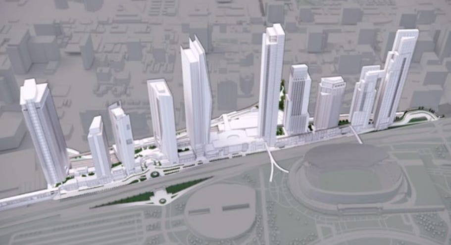
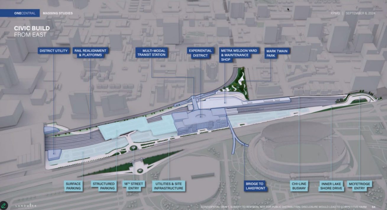
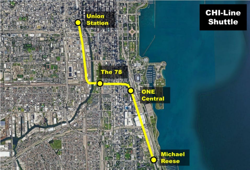
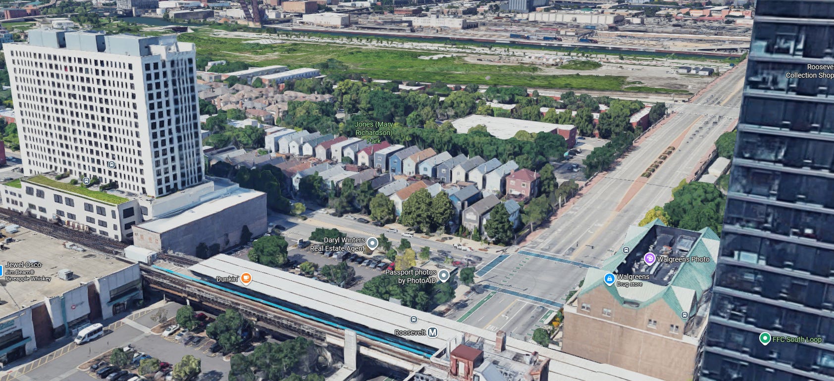
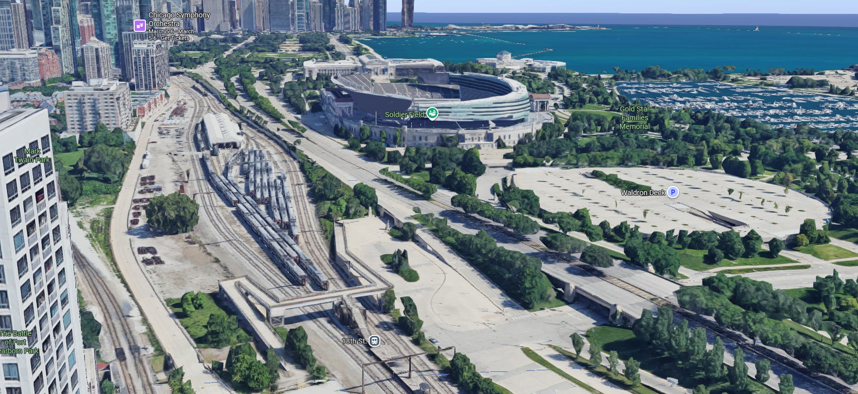
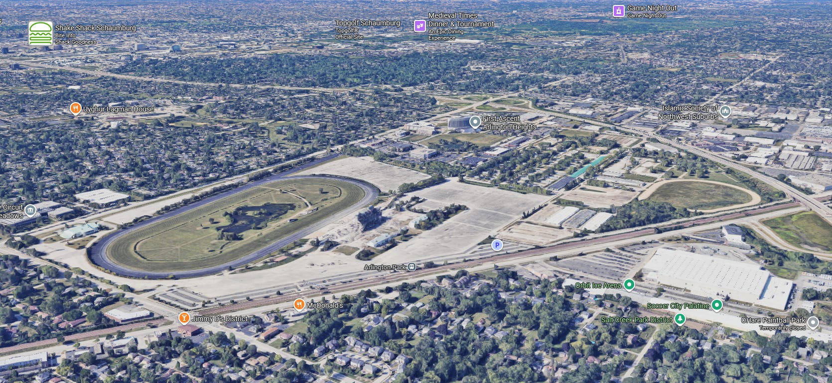

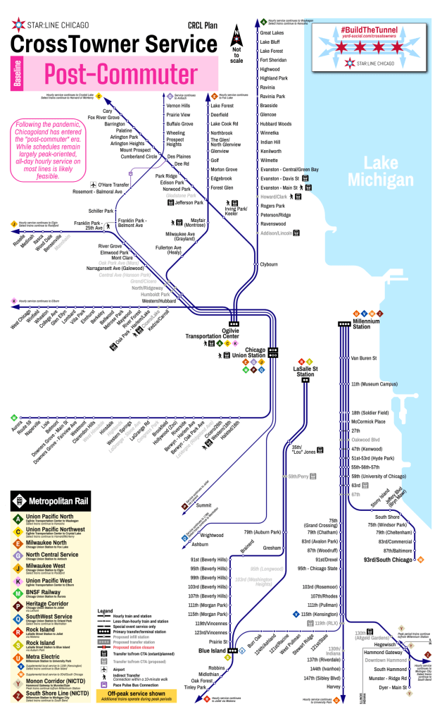

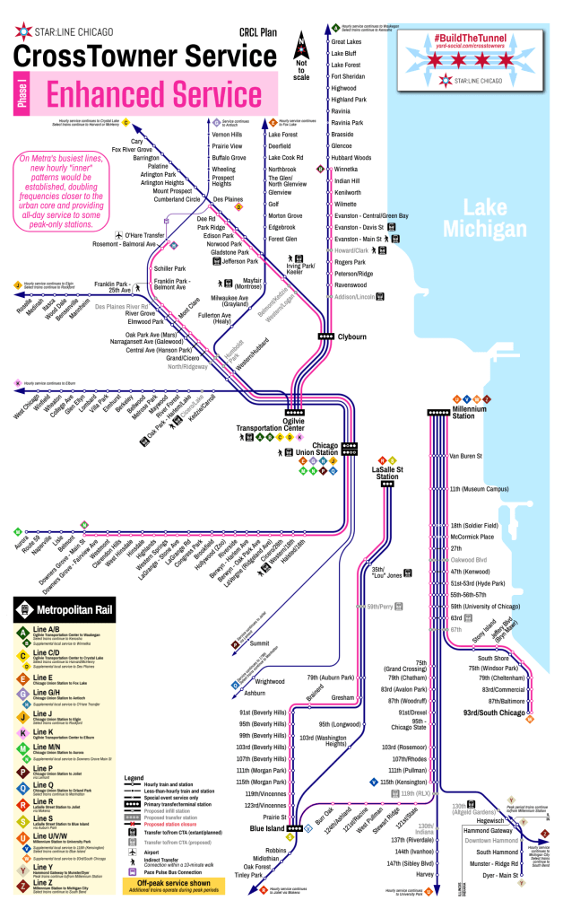
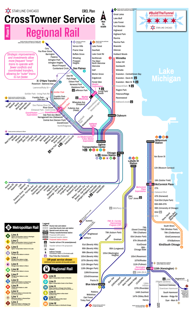
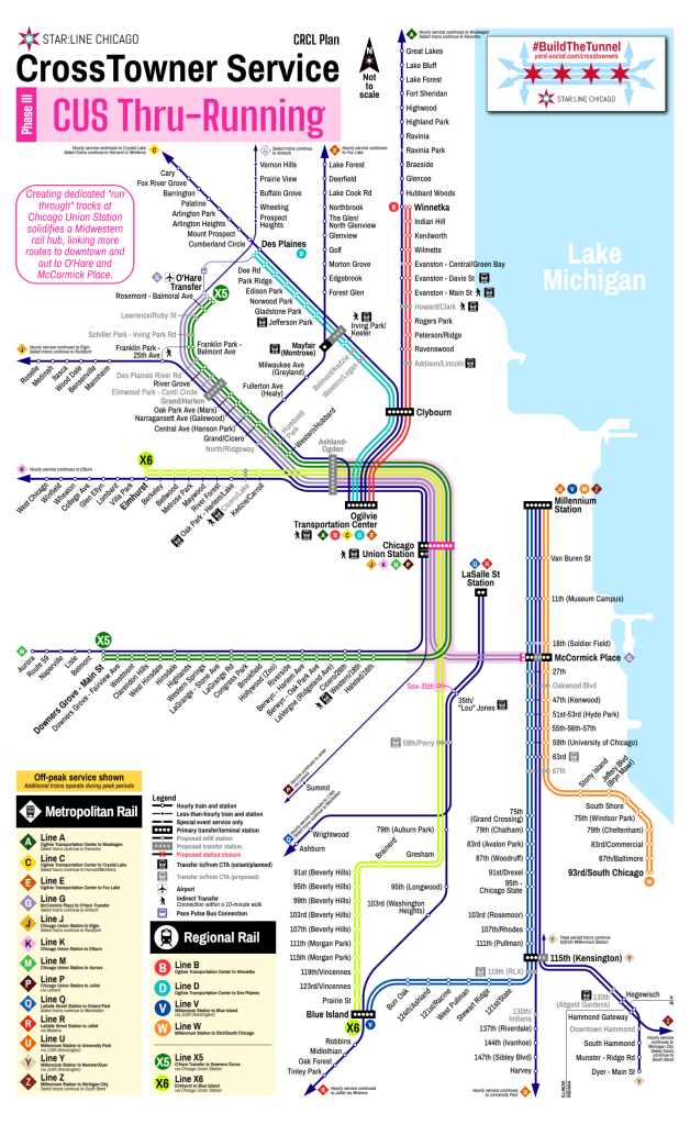
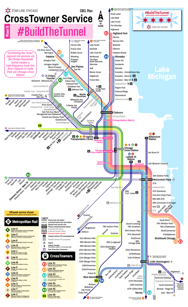
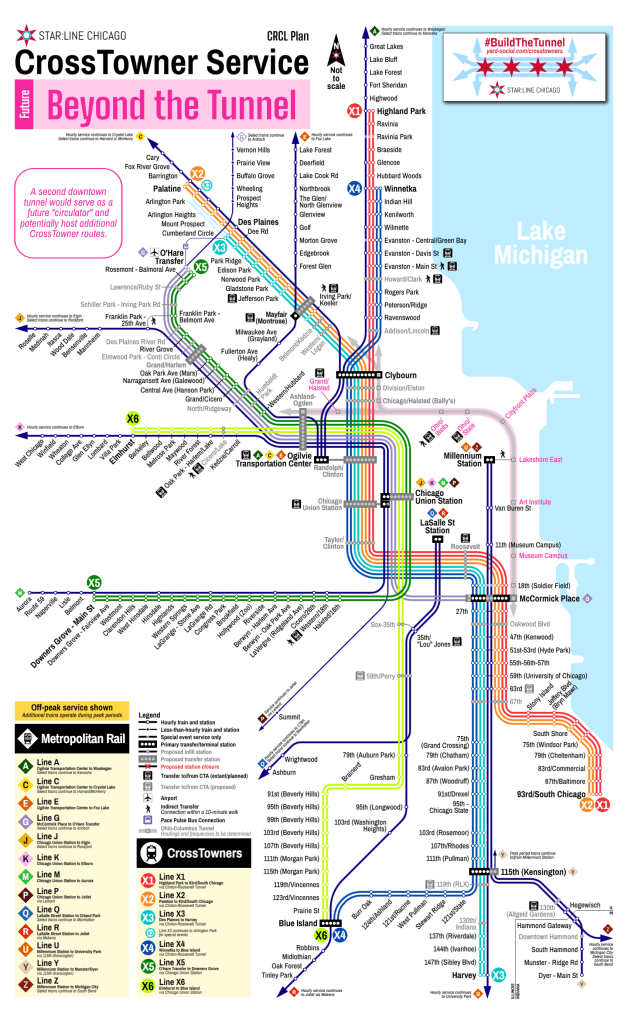
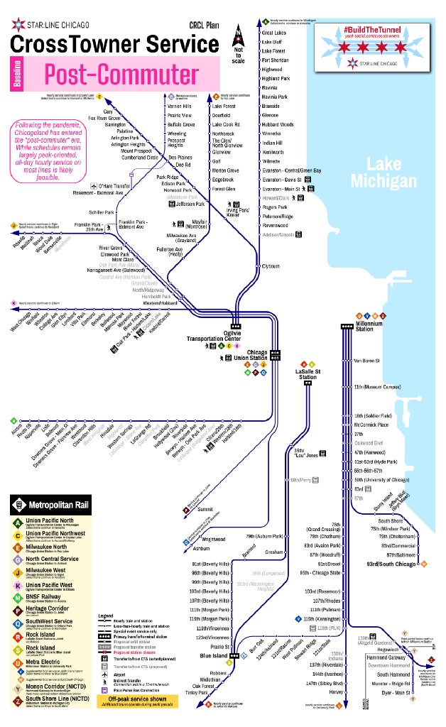
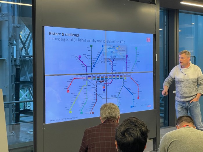

 but about half the trains terminate at 30th St with the other half split amongst the Thorndale (THO/MAL), Wawa (MED), and Newark (NWK/WIL) lines.")
. S-Bahn trains generally share tracks with regional trains that continue beyond the Munich metropolitan area.
Map from Wikipedia: https://en.wikipedia.org/wiki/Munich_S-Bahn#/media/File:Karte_der_S-Bahn_M%C3%BCnchen.png")
), with S-Bahn trains making local stops to allow intercity trains to operate faster.
Link to map: https://www.reddit.com/r/TransitDiagrams/comments/1htftoy/oc_regional_train_services_germany_2025/#lightbox")
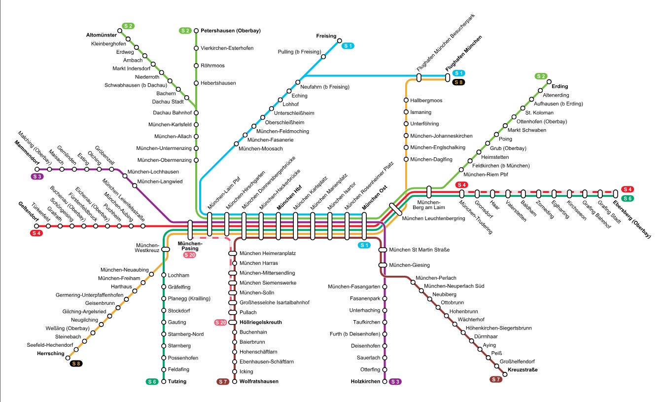
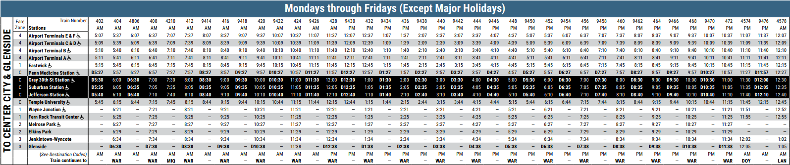

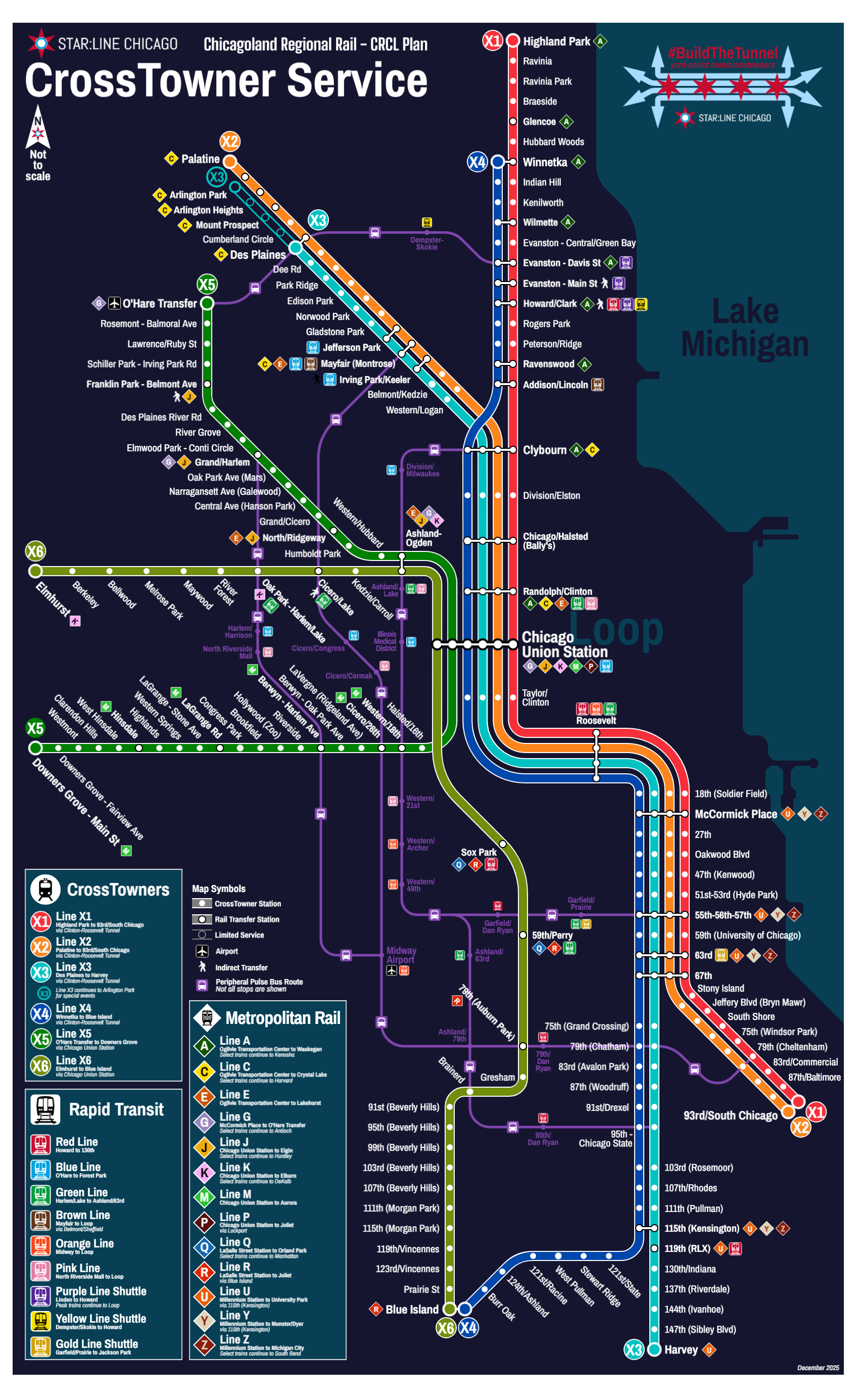


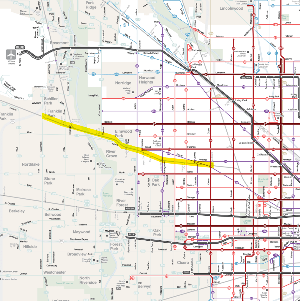
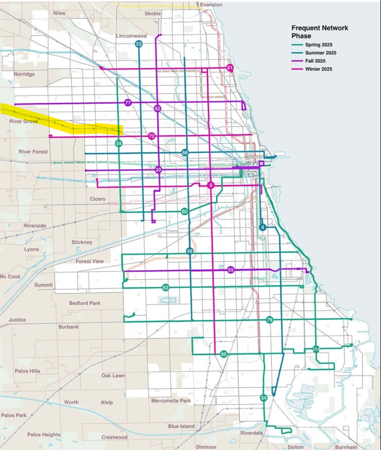
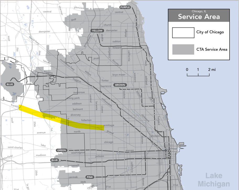

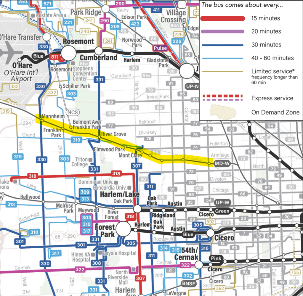
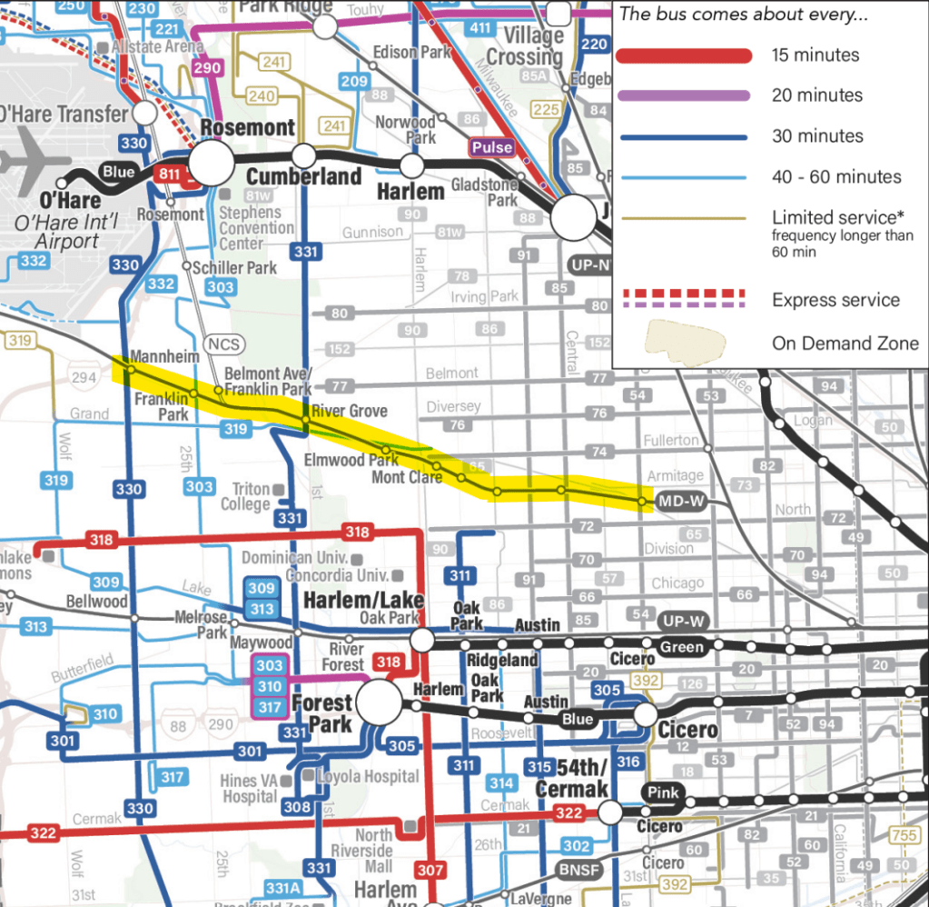

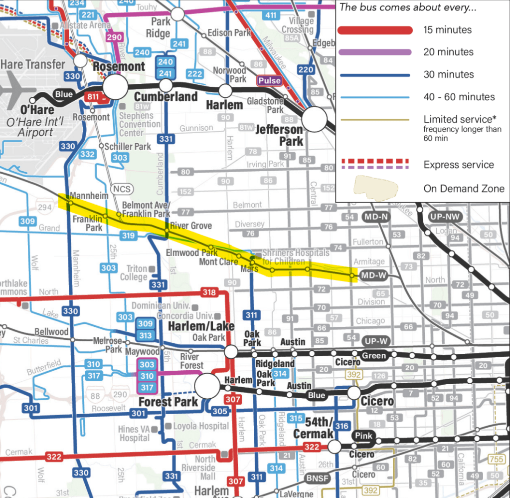
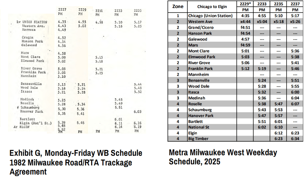
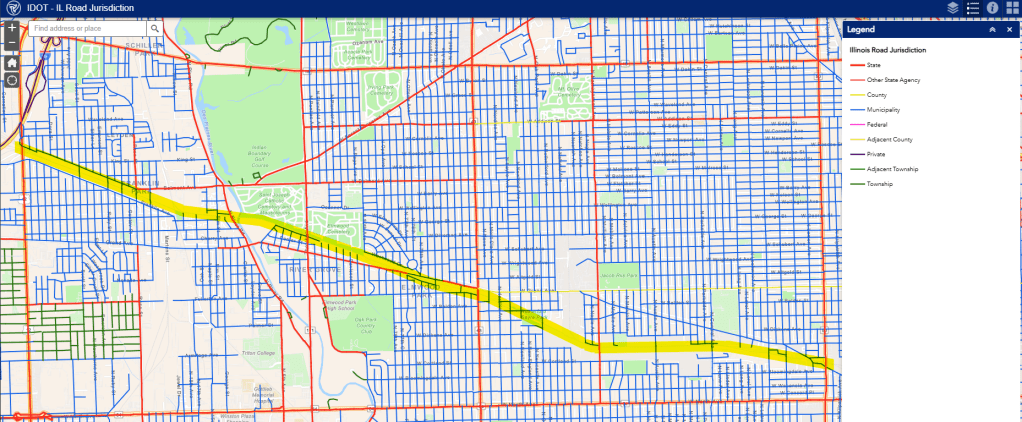
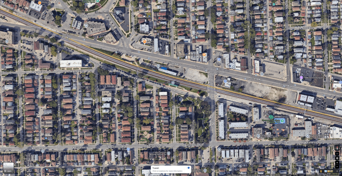


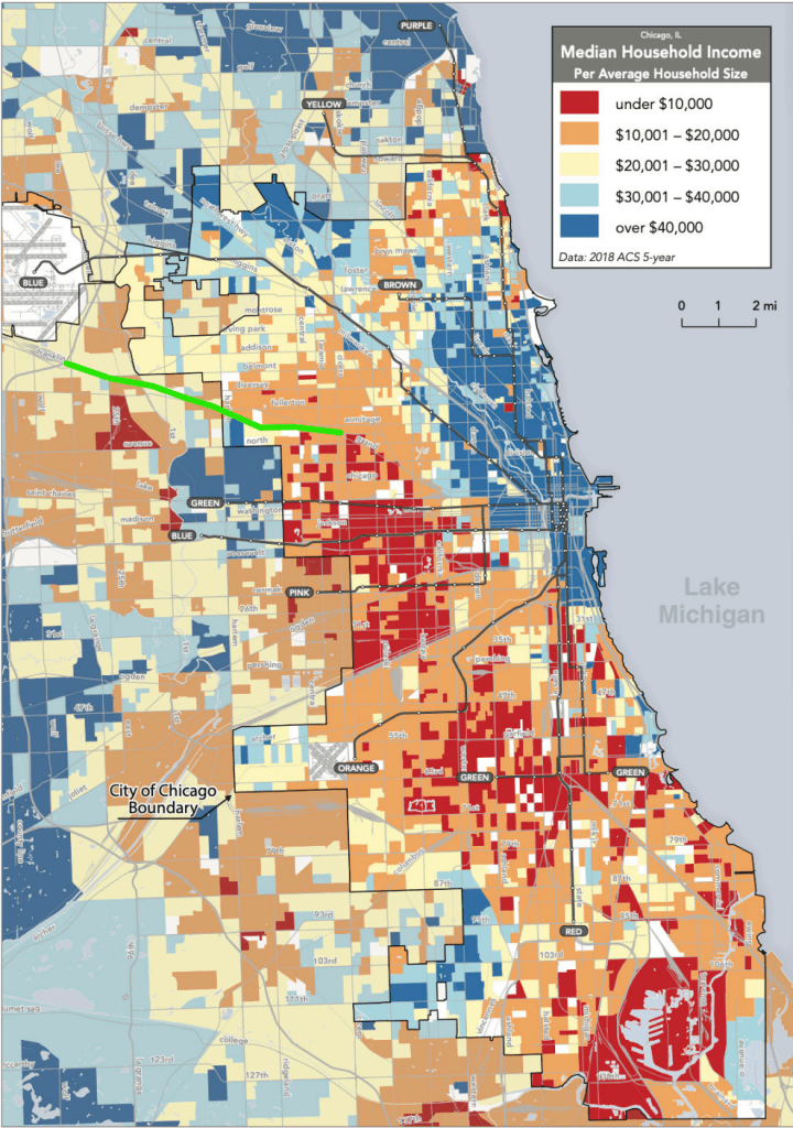


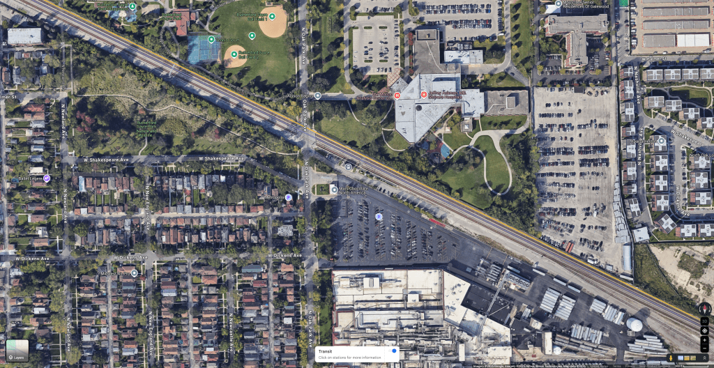

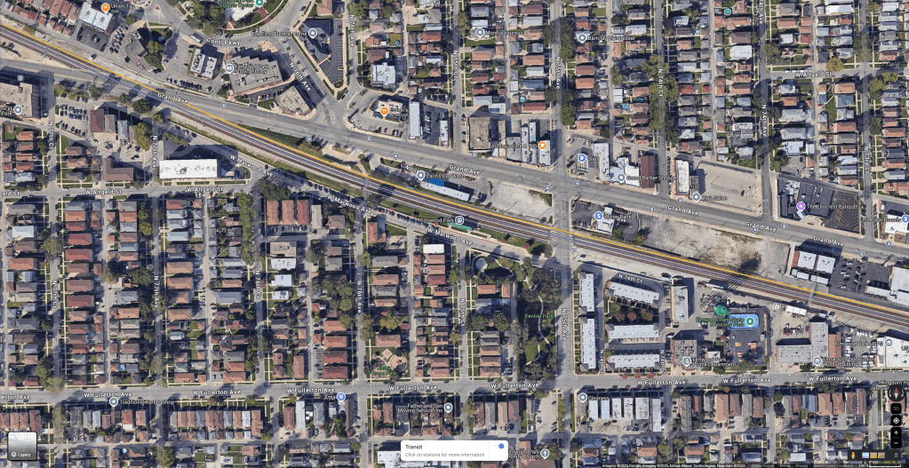


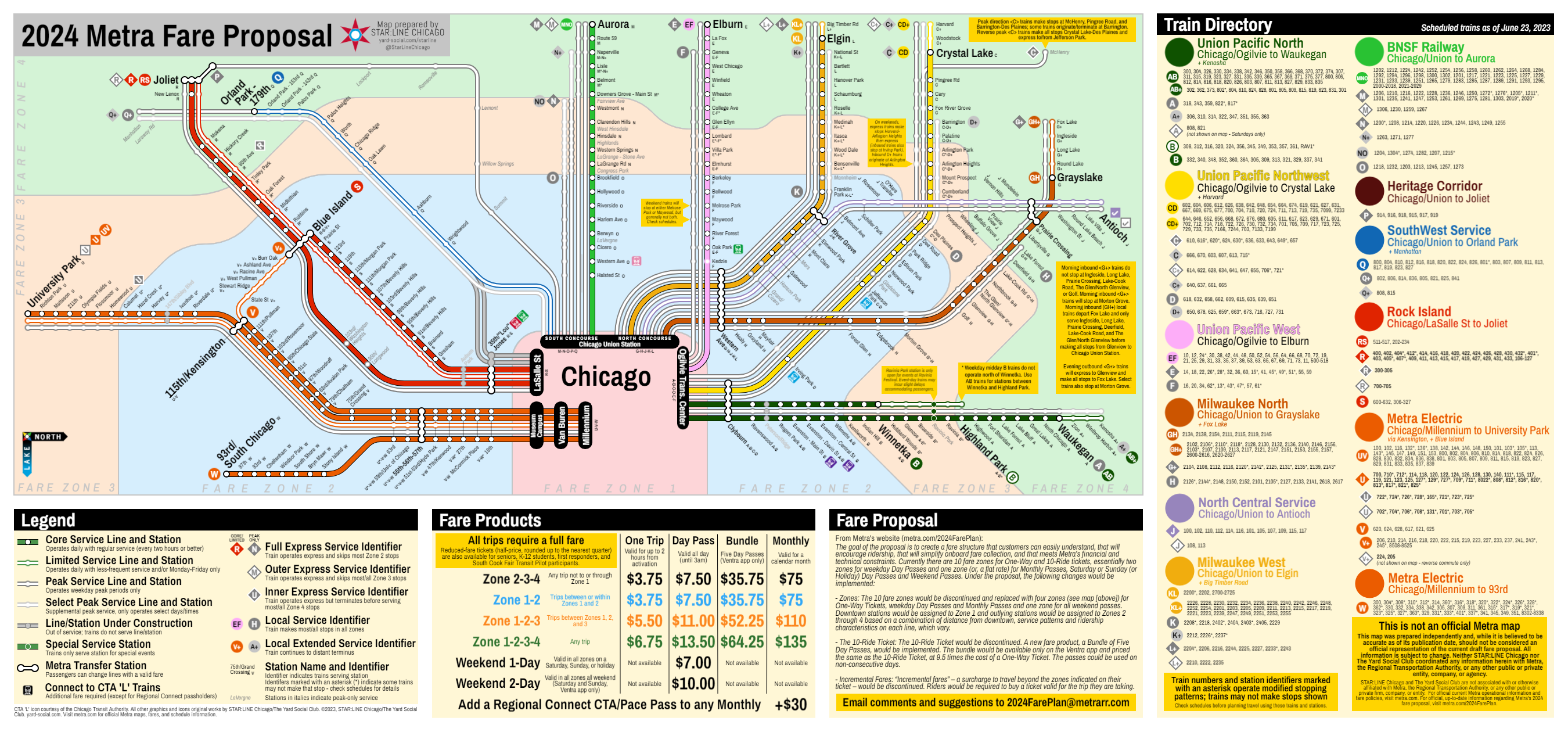

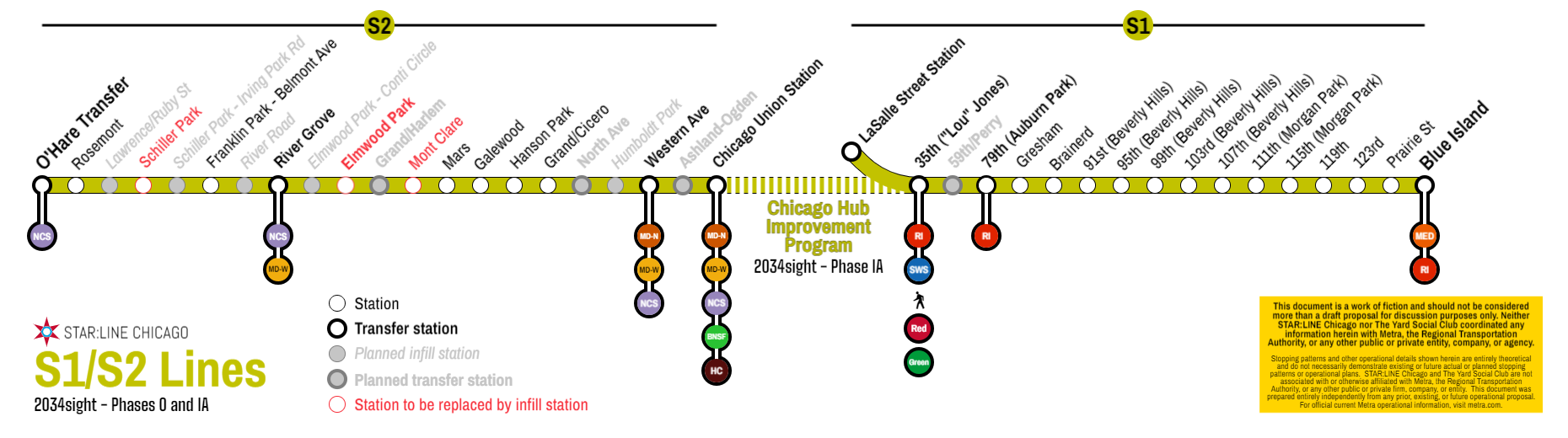
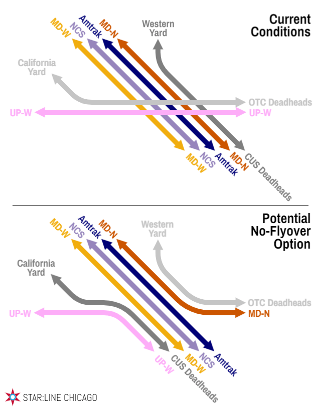


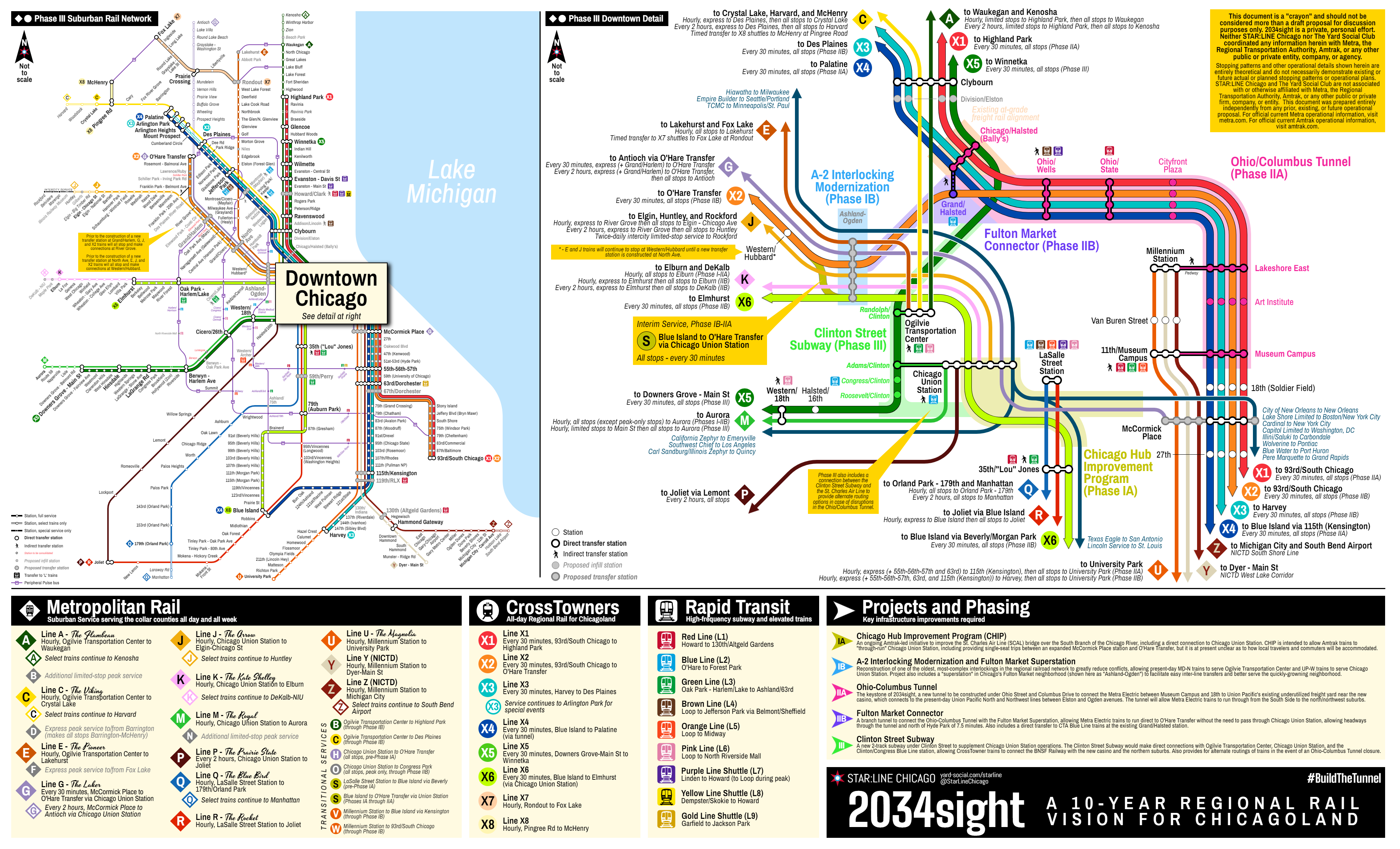

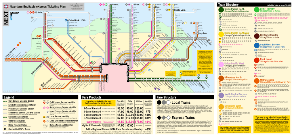

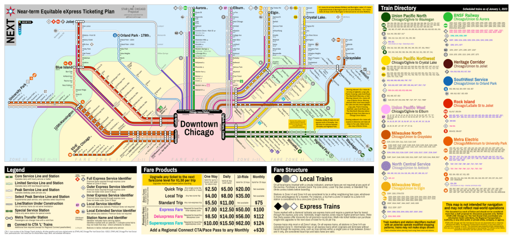

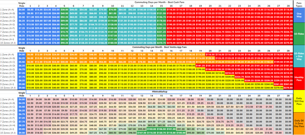
