
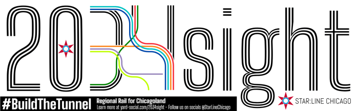
- A 10-Year Plan For Regional Rail in Chicagoland
- Tiers of Service
- Benefits
- A Three-Phase Process to Regional Rail
- What’s This Going to Cost?!
- What’s Next?
- Maps and Exhibits
- More Information
A 10-Year Plan For Regional Rail in Chicagoland
Download the 2034sight brochure here.
NEW: Download the CrossTowner “regional rail” overview brochure here.
(March 2025)
The only constant in life is change, and here in Chicagoland we’re facing an unprecedented period of change and challenges. Our transportation network is at a crossroads: COVID-era shifts in travel demand and commuting patterns, compounded by volatile fuel prices and impacts of ongoing climate change, require a bold, sustainable vision for our public transportation network. While there are no shortages of new ideas in terms of governance and interstate regional travel, we need a bold vision for riders who use the local system to rally around: moving Chicagoland through Chicagoland, neighborhood-to-neighborhood, suburb-to-suburb.
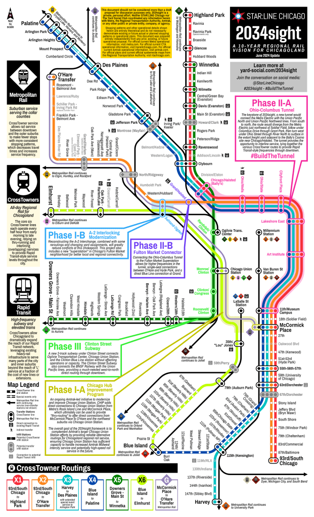
The 2034sight Plan is an ambitious — and achievable — ten-year framework to lay the groundwork to modernize Chicagoland’s existing local passenger rail system to create an efficient, effective public transit network that expands regional mobility, enhances regional equity, and puts Chicagoland on a more sustainable path to achieve our environmental goals in a cost-effective manner. The 2034sight Plan achieves these goals with five targeted projects that would allow our region to maximally leverage our existing rail network to create CrossTowners, a new six-line regional rail network that will serve as the nexus point of a modern, fully-integrated transit network.
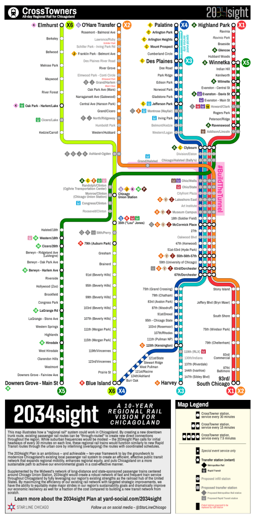
The 2034sight Plan strategically leverages Chicagoland’s existing rail network to provide a new, six-line, 150-station regional rail system to dramatically improve transit options throughout the city and suburbs, ranging from historically-disinvested communities on the South and West Sides to major job and residential centers like River North, Evanston, Arlington Heights, O’Hare, and more.
Tiers of Service
The 2034sight Plan focuses on three types of train service throughout Chicagoland:
- Metropolitan Rail: the un-portmanteau-ed version of Metra, 2034sight’s Metropolitan Rail service operates very similarly to today’s Metra suburban train service, with trips connecting the suburbs to downtown throughout the day, including with additional service during the busiest times of the day. However, the 2034sight Plan streamlines this service by reducing the need to serve as many stations in the city and inner suburbs, allowing suburban trains to lower trip times and with more predictable stopping patterns to make service faster and more frequent throughout Chicagoland.
- Rapid Transit: the more formal name for the existing ‘L’ network in Chicago and some inner suburbs, 2034sight includes only relatively modest changes to the ‘L’ itself, but creates a whole new network of service to dramatically expand the reach of rail transit in the City of Chicago, vastly increasing the reach of our existing Rapid Transit network for a fraction of the cost of building new lines or continuing to expand existing lines further into suburbia.
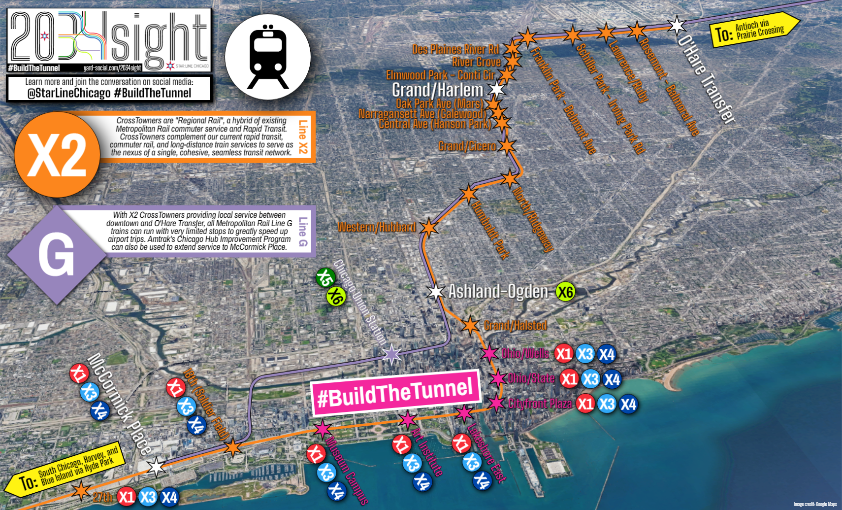
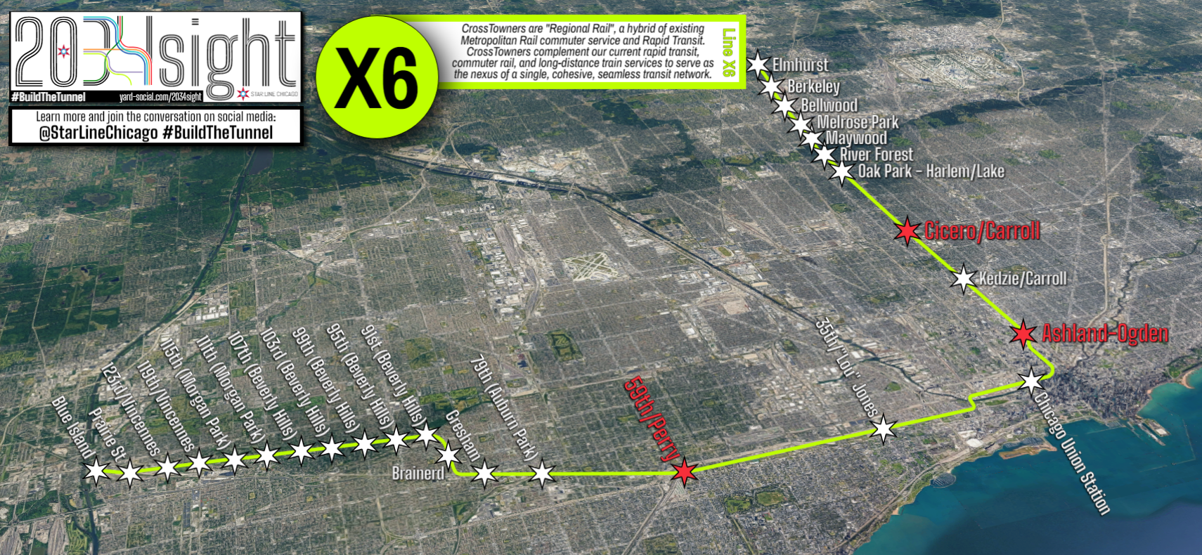
- CrossTowners: the crux of 2034sight, CrossTowners are a new-to-Chicagoland type and style of train service. Similar to “S-bahn” service in central Europe or “RER” service in France, CrossTowners are a hybrid between Metropolitan Rail and Rapid Transit. Operating on existing suburban railroads, the CrossTowners would be linked together to “thru-run” downtown Chicago on “interlined” (overlapping) routes that would also provide much higher frequency service for many parts of the city and inner suburbs that are far from existing ‘L’ Rapid Transit service.
Benefits
- Regional rail allows Chicagoland to more efficiently use our existing rail network. By “thru-routing”, or connecting these lines straight through downtown instead of continuing to have suburban trains terminate at the downtown stations, trains can operate straight through the heart of the city at higher frequencies, connecting neighborhoods and inner suburbs like never before, all for a fraction of the cost of new ‘L’ Rapid Transit lines.
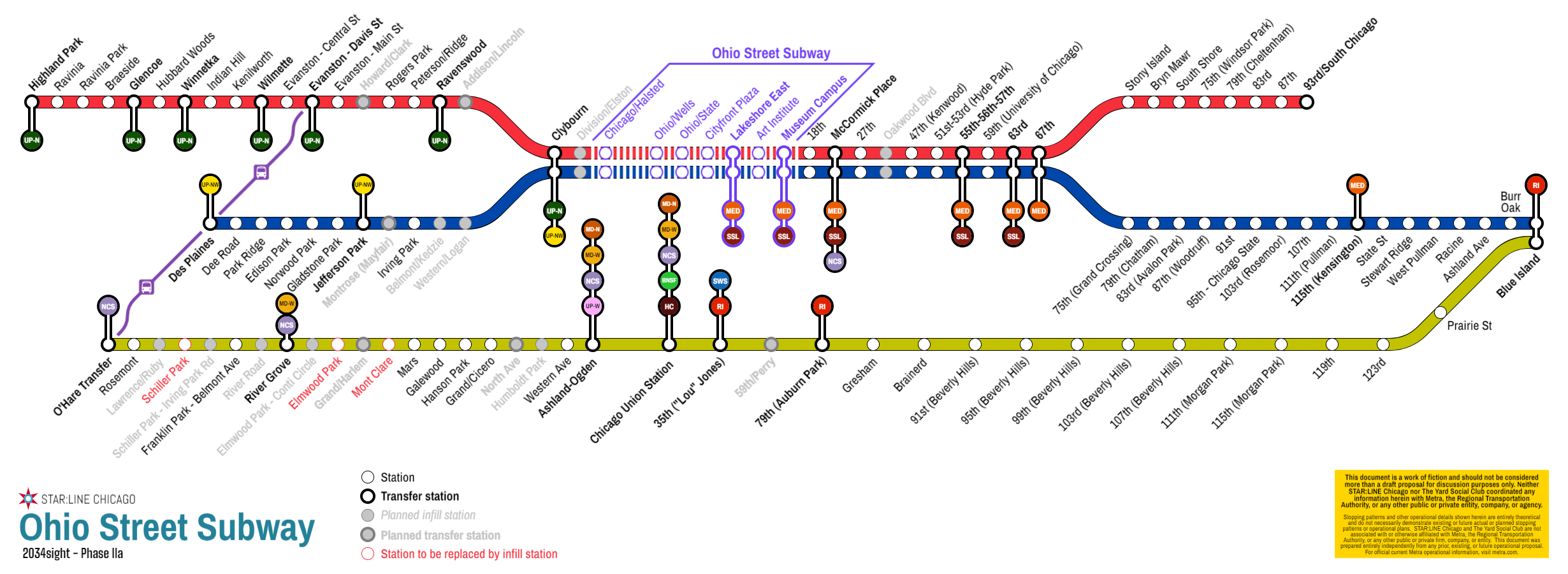
- Interlining provides Rapid Transit headways with Metropolitan Rail frequencies. While half-hour headways sound relatively modest — and for suburban areas, still a substantial improvement than the current hourly or worse frequencies — by having numerous lines overlap, these trains can function similar to a Rapid Transit line through the city. For instance, even as each individual line would run only twice an hour, through the downtown tunnel four lines overlap, providing 7.5-minute average headways, better than many CTA lines during off-peak periods. Additionally, with lines doubling up through much of the city, wide swaths of Chicago that are currently far from ‘L’ service like Grand Crossing, South Shore, and Edison Park would have service every 15 minutes, all day long.
- Separating suburban services between “inner” and “outer” zones speeds up trips for everyone. With more frequent train service on the inner parts of the suburban rail network, other Metropolitan Rail trains can skip more stops more often, reducing trip times and increasing frequencies even out in the collar counties. Almost every suburban train is an express train with 2034sight.
- Good jobs for Chicagoland workers, and good transit to connect more Chicagolanders to more jobs throughout the region. 2034sight calls for some pretty substantial investments in new infrastructure, but unlike endless highway maintenance and widening projects, 2034sight creates a more environmentally-sustainable transportation system for all of us. Clean, green, modern jobs to create new neighborhood-to-neighborhood, suburb-to-suburb links throughout Chicagoland.
- Equity, with efficiency. The transit benefits of 2034sight would be overwhelmingly targeted at historically-disinvested communities on Chicago’s South and West Sides, dramatically enhancing transit equity with single-seat, fast and frequent rail transit trips from the Far South Side to River North, Evanston, Arlington Heights, O’Hare and more. Additionally, huge swaths of the West Side and west suburban Cook County will also see improvements with more frequent local trains along the Milwaukee West and Union Pacific West lines. However, this isn’t just a jobs program: by strategically targeting investments to improve on our existing Chicagoland rail network, 2034sight provides taxpayers with a maximum return on their investment by creating new ways to operate our existing network far more efficiently rather than building a totally new transit network from scratch.
A Three-Phase Process to Regional Rail
There are three basic phases to the plan:
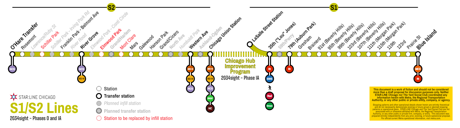
- Phase I: Transform Chicago Union Station into the Midwest’s premier passenger rail hub, both locally and regionally. Chicago Union Station, already one of Metra’s primary hubs of operations and Amtrak’s busiest station outside of the Northeast Corridor, is a huge asset to our regional transportation system. However, it is not as efficient or effective as it could be, due mostly to historical quirks: as a dual-stub station, trains generally can only go to — but not through — Chicago Union Station, and trains from the south need to take circuitous routings through Chicago to access the station. Additionally, from the north, trains must also pass through a busy at-grade interlocking junction known as A-2 near Western Avenue where trains heading to/from the Ogilvie Transportation Center must cross trains heading to/from Chicago Union Station. The first two projects in the 2034sight Plan are already underway in some way, shape, or form: Metra has preliminarily discussed modifications to A-2 including a new Fulton Market infill station, and Amtrak is currently seeking funding for their ambitious Chicago Hub Improvement Program (CHIP), which will decongest the southern approach to Chicago Union Station and create more efficient routings for Amtrak trains through Chicago’s South Side. The 2034sight Plan fully supports these two projects, and by creating a longer-term vision, will ensure that these forthcoming projects are implemented to maximize flexibility and utilization with a future regional rail operating plan. Additionally, these improvements would create the first all-stop “regional rail” route by connecting the Rock Island Suburban (Beverly) Branch to the Milwaukee West line, creating a through-route from Blue Island to O’Hare Transfer via Union Station and River Grove. In doing so, an “O’Hare Express” service would naturally evolve, as all existing NCS trains could operate basically non-stop between Chicago Union Station and O’Hare Transfer.
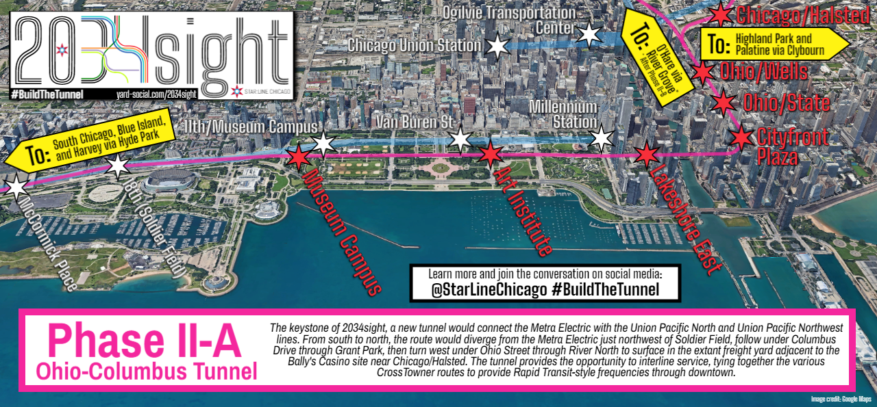
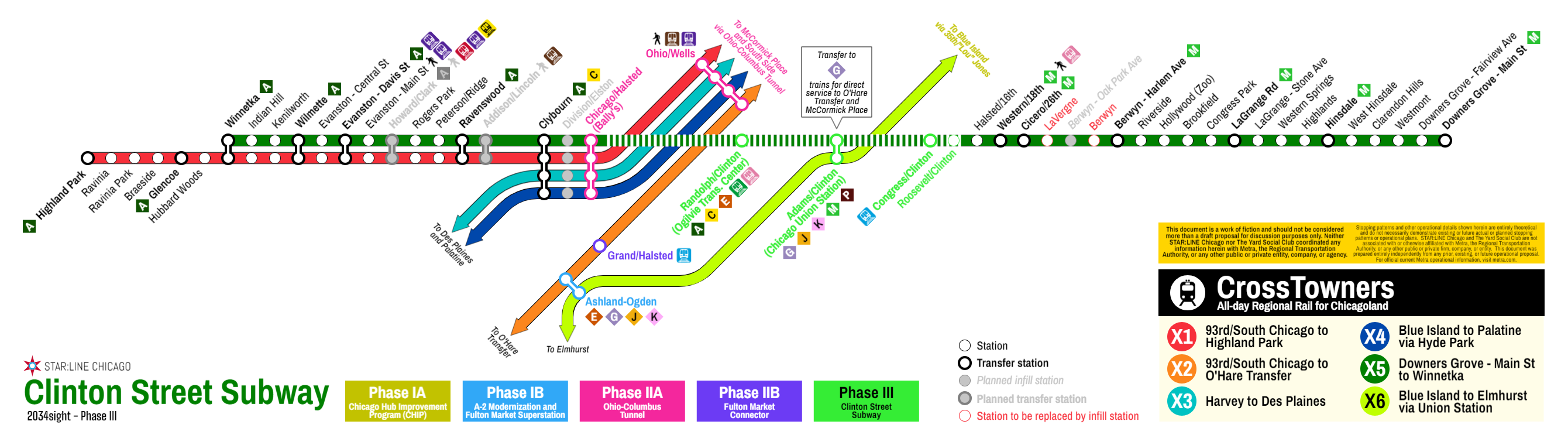
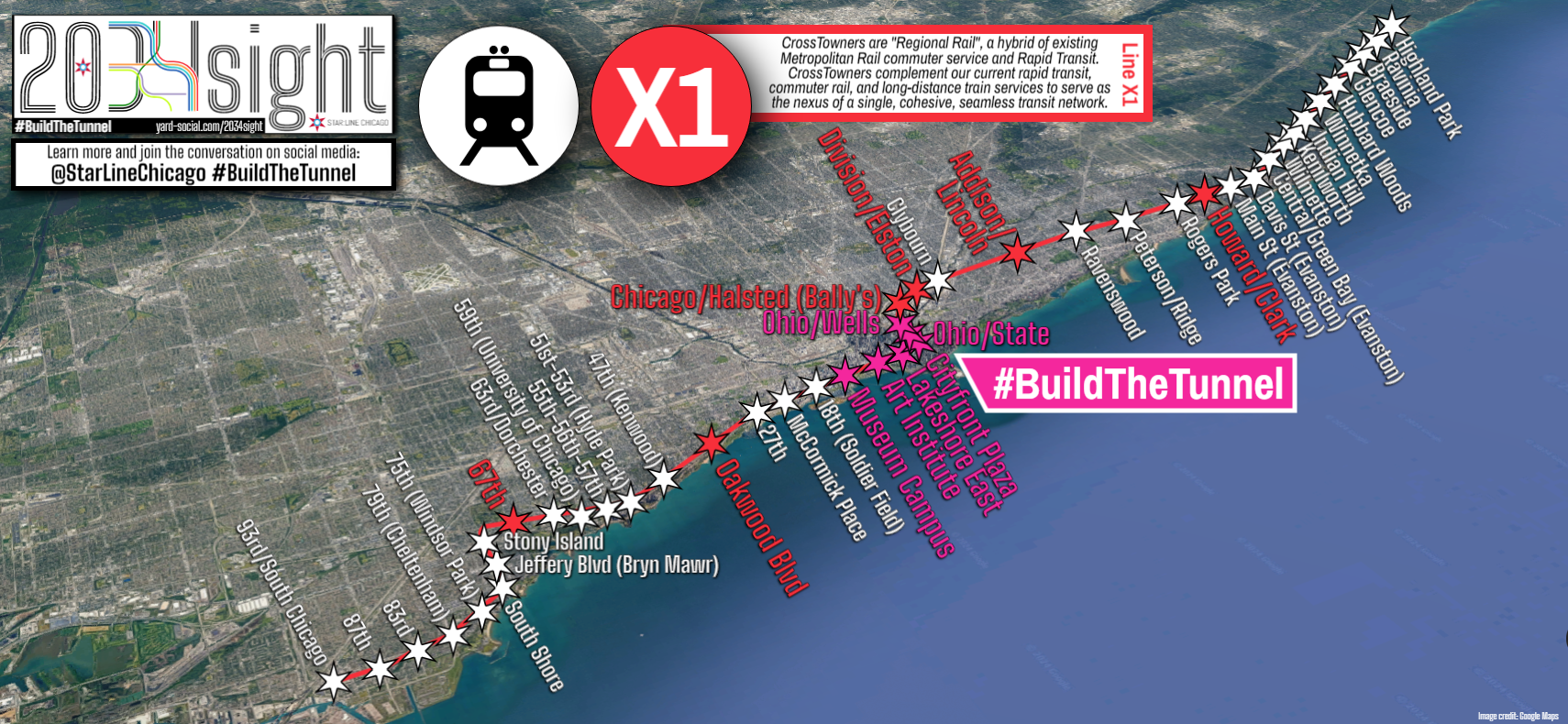
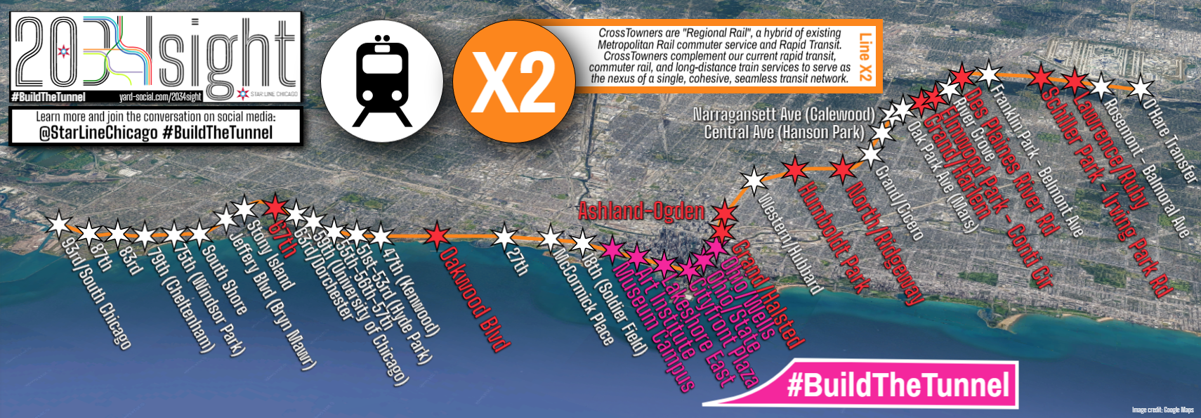
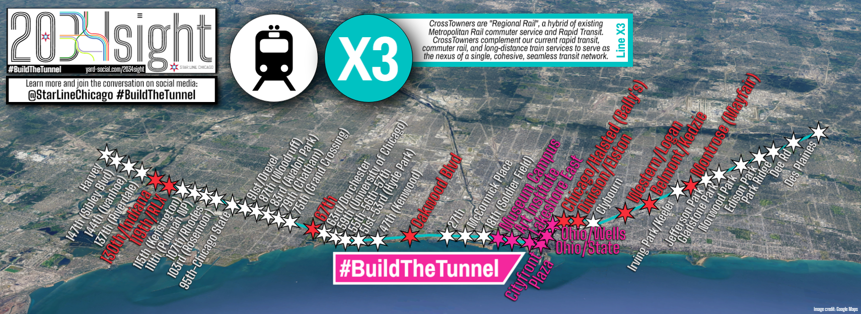
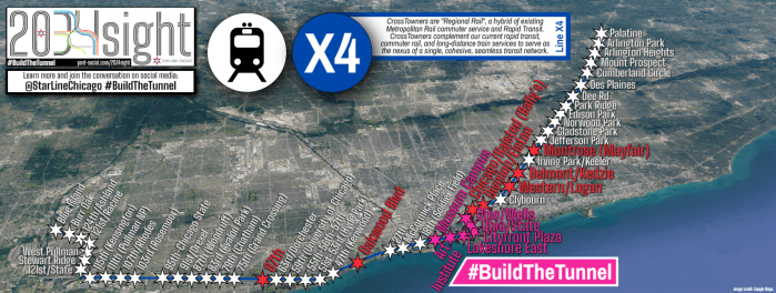
- Phase II: #BuildTheTunnel, a new infrastructure corridor to move local trains to — and through — downtown Chicago. While Chicago Union Station will become a stronger hub for Amtrak’s intercity routes and for Metra’s more traditional peak-oriented suburban commuter operations, there remains no easy way to connect Metra’s busiest existing train lines: namely, the BNSF and Metra Electric trains entering downtown from the west and south, respectively, with the Union Pacific North and Northwest lines that enter from the north. The crux of the 2034sight Plan is the Ohio-Columbus Tunnel, a new, electrified two-track tunnel that would connect the Museum Campus to the new Bally’s Casino site at Chicago/Halsted, plus a branch to connect to the aforementioned Fulton Market “superstation”. The Ohio-Columbus Tunnel and the Fulton Market Connector — combined a comparable length to the CTA’s State Street Subway — would create the first four CrossTowner routes by running local Metra Electric trains through the tunnel and out to the north and northwest suburbs. While each individual route would operate every 30 minutes, the lines overlap, providing service every 15 minutes on Metra Electric’s existing operations south of 67th Street, and down to every 7.5 minutes through Hyde Park and River North.

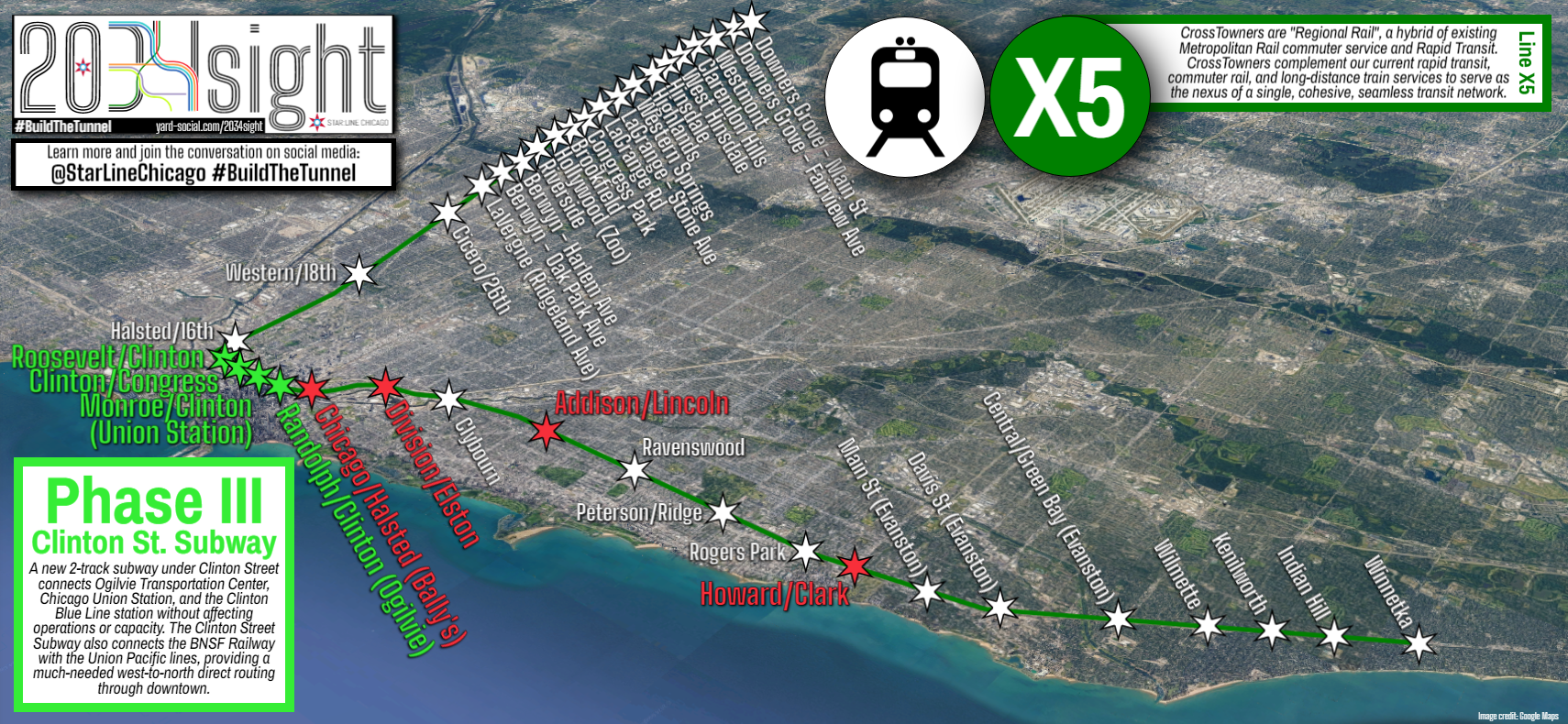
- Phase III: Maximize the network’s utility with a West Loop north-south route. The final phase in 2034sight’s ten-year horizon is a second tunnel under Clinton Street that would connect the BNSF Railway with the Ohio-Columbus Tunnel via Chicago Union Station. This final improvement would create a west-north CrossTowner route and better integrate Ogilvie Transportation Center, Chicago Union Station, and the Clinton Blue Line while also enhancing reliability and resiliency by creating an alternate route for trains using the Ohio-Columbus Tunnel. (Phase III can also be accomplished with more aggressive renovations to Chicago Union Station as part of Amtrak’s CHIP initiative.)
What’s This Going to Cost?!
Make no doubts, 2034sight would be a megaproject. Detailed cost estimates and designs have not yet been created for 2034sight; the proposal is still relatively in its infancy and more research will have to be done. However, for very broad contours:
| Phase/Project | Cost Estimate | Notes and Sources |
| Phase I-A: Chicago Hub Improvement Program (CHIP) | $0.44 billion | 2022 CMAP fact sheet, inflation adjusted. Note the estimate also includes projects outside the scope of 2034sight, including Chicago-Detroit Amtrak improvements. |
| Phase I-B: A-2 Improvements and Fulton Market Superstation | $1.50 billion | 2021 CDOT/DPD/Metra community meeting, inflation adjusted. Lower bound used, but likely still an overestimate as Metra’s cost includes a new flyover structure, which would largely be made irrelevant by 2034sight’s proposed reroutings. |
| Phase II-A: Ohio-Columbus Tunnel | $4.00 billion | Assuming $1B/mile for four miles of tunnel. Based on a $900M/mile total final cost for Los Angeles’ recently-opened Regional Connector. May be an overestimate considering the first mile under Columbus Drive can be completed as a cheaper cut-and-cover project. |
| Phase II-B: Fulton Market Connector | $1.25 billion | Same $1B/mile estimate as above for roughly 1.25 miles of tunnel. |
| Phase III: Clinton Street Subway | $2.50 billion | Same $1B/mile estimate as above for roughly 2.5 miles of tunnel, but likely an overestimate since, without river crossings, most or all of the Clinton Street Subway could be built with cheaper cut-and-cover techniques. Additionally, a more aggressive CHIP program may reduce or eliminate the need for the Clinton Street Subway if a northern connection to the UP-N/NW can be accommodated along with other Union Station thru-running improvements. |
| Rolling stock | $1.00 billion | Rough estimate; mostly a conservative placeholder. Metra is purchasing a lighter, modern fleet of 16 trainsets from Stadler that could theoretically perform CrossTowner service for a cost of $336 million, but a much larger fleet would likely be required for full service. |
| Station upgrades and new infill stations | $1.00 billion | Rough estimate and variable based on number and location of new infill stations. |
| Total Cost, 2024 dollars | $11.69 billion | Successful federal grant applications would generally cover up to 50% of the total cost of the project. |
While nearly $12 billion is certainly nothing to sneeze at, it’s worth contextualizing what this project would provide to Chicagoland: for about three times the cost of the CTA’s ongoing Red Line Extension (approximately $3.948 billion), Chicagoland could have a new, 150-station network that spans the city and much of Suburban Cook County while providing significant improvements to transit trips throughout all six Chicagoland counties, including Rapid Transit-style train frequencies to numerous historically-disadvantaged neighborhoods throughout Chicagoland.
What’s Next?
While the immediate priority for Chicagoland transit is ensuring our local transit agencies don’t go over the fiscal cliff in the next year or two, now is the time to focus on the kinds of strategic investments the 2034sight Plan identifies that will allow Chicagoland to emerge from the pandemic era with a modern, cost-effective transit network. Ultimately, the 2034sight Plan is simply a road map that can align existing projects and priorities from a variety of agencies — CTA’s Red Line Extension, Metra’s transition to regional rail, Amtrak’s Chicago Hub Improvement Program and Amtrak Connects US — with a unified vision and path forward, avoiding the siloed approaches and inefficiencies of the past to finally build a 21st-Century rail transit network for Chicagoland.
If the 2034sight Plan sounds like a good idea to you, talk to your local elected representatives and spread the word. This website is yard-social.com/2034sight, and we have a handy PDF brochure that summarizes the plan and provides more detail.
You can also get social with StarLineChicago on Twitter, Threads, BlueSky, and Instagram. (#2034sight #BuildTheTunnel)
If you have questions about 2034sight, feel free to contact us through this website.
Maps and Exhibits
All maps can be viewed and downloaded as PDFs (unless otherwise noted) by clicking on the image.
System Map
Note that this map includes several other ancillary projects that are not included in the core cost scope of 2034sight, including suburban rail shuttles in McHenry and Fox Lake; a Brown Line extension to Jefferson Park; a shuttle service and ‘L’ extension to Jackson Park; and a peak-period Purple Line extension to Jackson Park.

Line Maps
Note: Line maps are not currently available as PDFs.
Downtown RTA-Style Map

Frequency Chart
Metropolitan Rail System Map

O’Hare Service Map
Interactive Map
Click on the square on the right side of the map’s top toolbar to open this map in a new window.
More Information
For more information about the plan, and to download a printable information sheet, click here. You can also read the original 2034sight Plan post on the Diverging Approach blog.

#BuildTheTunnel